Apache County, Arizona
County seat: St. Johns · Population 64,445 (2025) · 11,198 sq mi
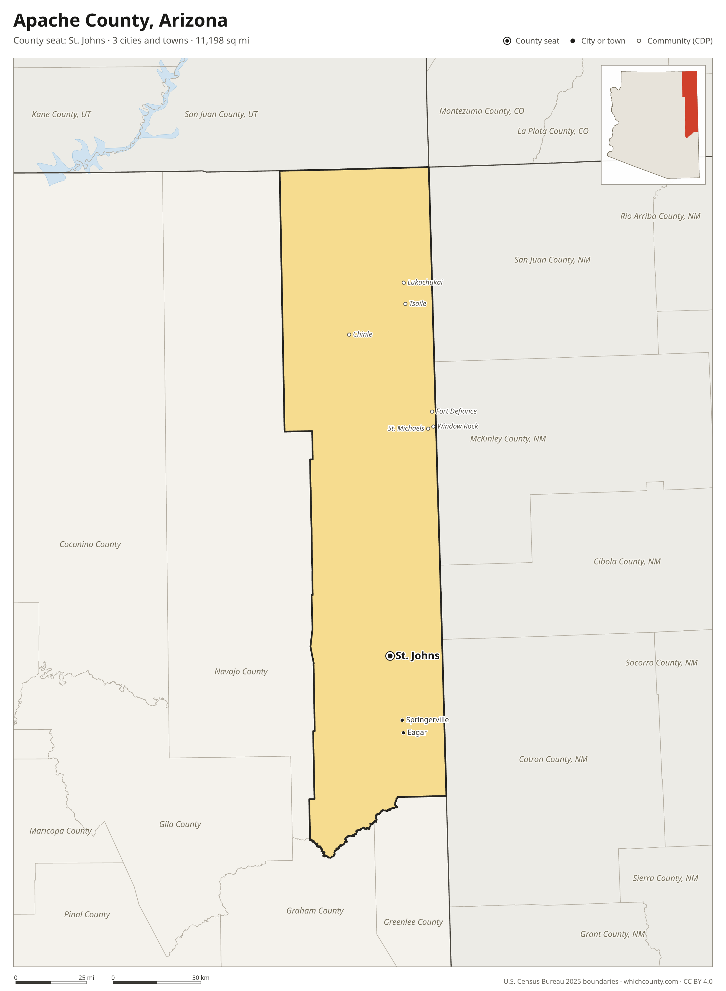
Apache County is the 10th most populous of Arizona's 15 counties, with 64,445 people (2025 estimate). Its county seat is St. Johns. The map shows its 3 cities and towns and the 9 neighboring counties.

Apache County facts
- County seat
- St. Johns
- Population (2025 estimate)
- 64,445 −2.4% since 2020
- Land area
- 11,198 sq mi 3rd largest of 15
- Water area
- 21 sq mi
- Population density
- 6 per sq mi
- Established
- 1879
- Named after
- Apache several culturally related groups of indigenous peoples of the United States
- Largest city
- Eagar 4,459
- Median household income
- $41,438
- Cities and towns
- 3 plus 36 CDPs
- ZIP codes
- 34
- Time zone
- Mountain (no DST; Navajo Nation observes DST)
- FIPS code
- 04001
Cities and towns in Apache County
Apache County has 3 incorporated cities, towns and villages. Populations count the people living inside Apache County; cities that cross a county line also list the other counties.
| Name | Type | Population 2025 | Also in |
|---|---|---|---|
| Eagar | Town | 4,459 | |
| St. Johns (county seat) | City | 3,336 | |
| Springerville | Town | 1,719 |
Unincorporated communities (CDPs)
Census-designated places are communities without their own city government; the county provides their services.
| Community | Population | Also in |
|---|---|---|
| Chinle | 4,147 | |
| Fort Defiance | 3,351 | |
| Window Rock | 2,477 | |
| Lukachukai | 1,969 | |
| Tsaile | 1,696 | |
| St. Michaels | 1,142 | |
| Many Farms | 876 | |
| Teec Nos Pos | 712 | |
| McNary | 708 | Navajo County |
| Houck | 707 | |
| Sanders | 684 | |
| Ganado | 637 | |
| Sawmill | 636 | |
| Round Rock | 623 | |
| Dennehotso | 574 | |
| Nazlini | 527 | |
| Rough Rock | 465 | |
| Del Muerto | 439 | |
| Burnside | 434 | |
| Red Mesa | 430 | |
| Nutrioso | 427 | |
| Steamboat | 372 | |
| Rock Point | 345 | |
| Cornfields | 320 | |
| Vernon | 247 | |
| Sehili | 229 | |
| Klagetoh | 158 | |
| Cottonwood | 149 | |
| Red Rock | 83 | |
| Alpine | 55 | |
| Oak Springs | 47 | |
| Wide Ruins | 29 | |
| Lupton | 4 | |
| Concho | 0 | |
| Greer | 0 | |
| Toyei | 0 |
ZIP codes in Apache County
34 ZIP codes reach into Apache County. ZIP codes ignore county lines, so some also cover a neighboring county.
- 84531
- 85901 also Navajo County
- 85920
- 85924
- 85925
- 85927
- 85930 also Navajo County
- 85932
- 85936
- 85938
- 85940
- 86028
- 86033 also Navajo County
- 86034 also Navajo County
- 86502
- 86503 also Navajo County
- 86504
- 86505 also Navajo County
- 86506
- 86507
- 86508
- 86511
- 86512
- 86514
- 86515
- 86520 also Navajo County
- 86535
- 86538
- 86540
- 86544
- 86545
- 86547
- 86556
- 87328
Population of Apache County, 2020–2025
Apache County shrank by 1,600 people (−2.4%) between April 2020 and July 2025: 1,412 more deaths than births and a net loss of 222 people from migration.
| Year (July 1) | Population |
|---|---|
| 2020 | 65,913 |
| 2021 | 65,339 |
| 2022 | 65,361 |
| 2023 | 65,055 |
| 2024 | 64,695 |
| 2025 | 64,445 |
Neighboring counties
- Navajo County west · 109,946 people
- McKinley County, New Mexico east · 68,119 people
- San Juan County, New Mexico northeast · 120,340 people
- Catron County, New Mexico southeast · 3,827 people
- San Juan County, Utah north · 14,542 people
- Graham County south · 40,157 people
- Greenlee County south · 9,312 people
- Cibola County, New Mexico east · 26,807 people
- Montezuma County, Colorado north · 26,678 people
Printable Apache County map
The PDF is a vector file with real text: it prints sharp on Letter paper and you can search it for a town. The PNG is 2400 pixels wide for slides and documents. Both are free to use with a credit to WhichCounty.
- PDF (Letter) (187 KB)
- PNG (2400 px) (142 KB)
Paste this code to embed the map on your site:
Sources
- Boundaries: U.S. Census Bureau, 2025 Cartographic Boundary Files (1:500,000).
- Population: Census Bureau county and city estimates, Vintage 2025. CDP populations: American Community Survey 2020–2024.
- Places and ZIP codes: Census Bureau 2026 Gazetteer and 2020 ZIP Code Tabulation Area relationship files.
- County seat, founding year and name origin: Wikidata (CC0), checked against state sources.
Back to the Arizona county map with all 15 counties. Found an error? Tell us.