Montana County Map
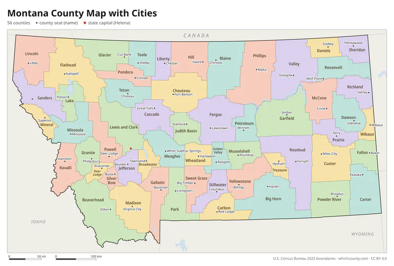
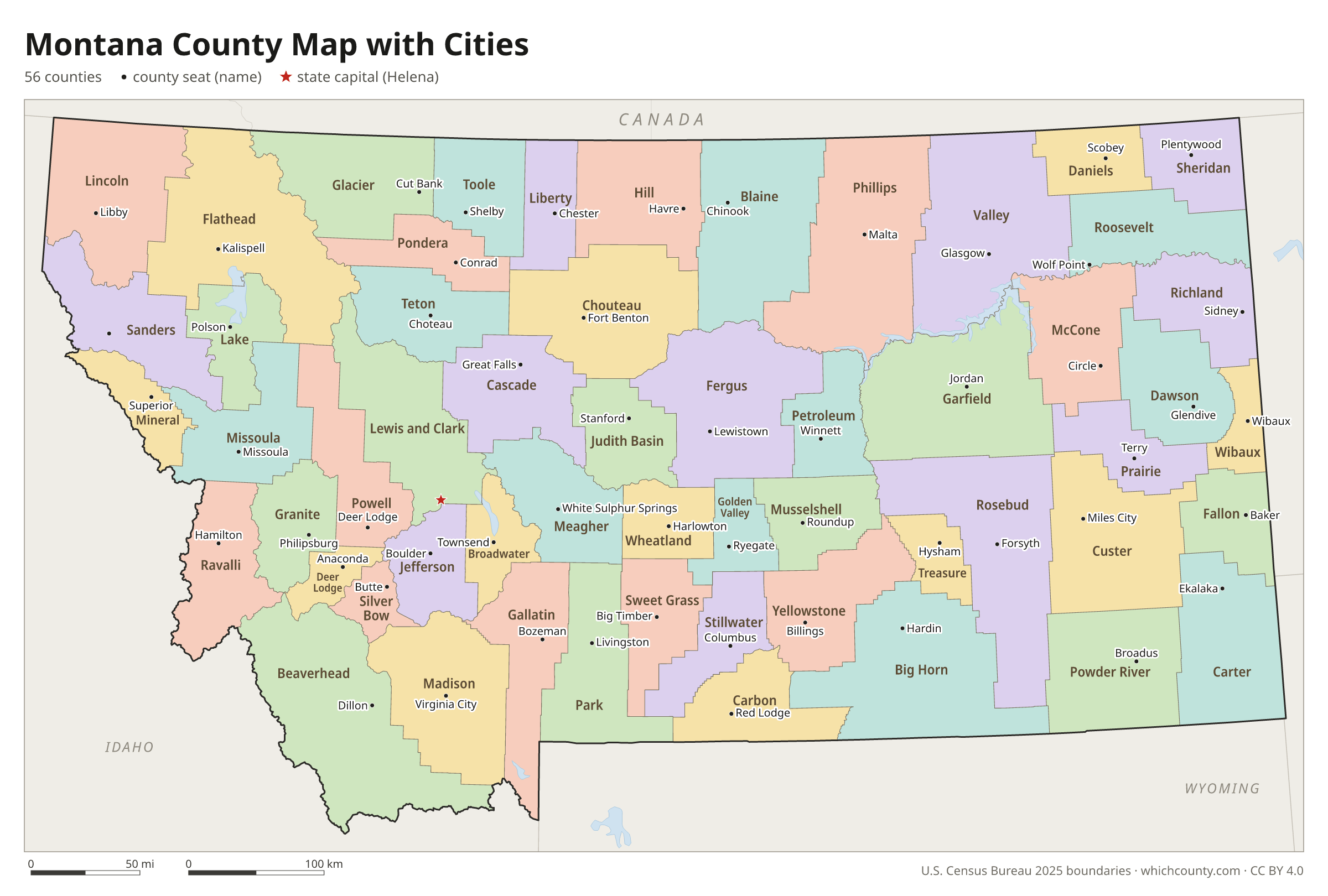
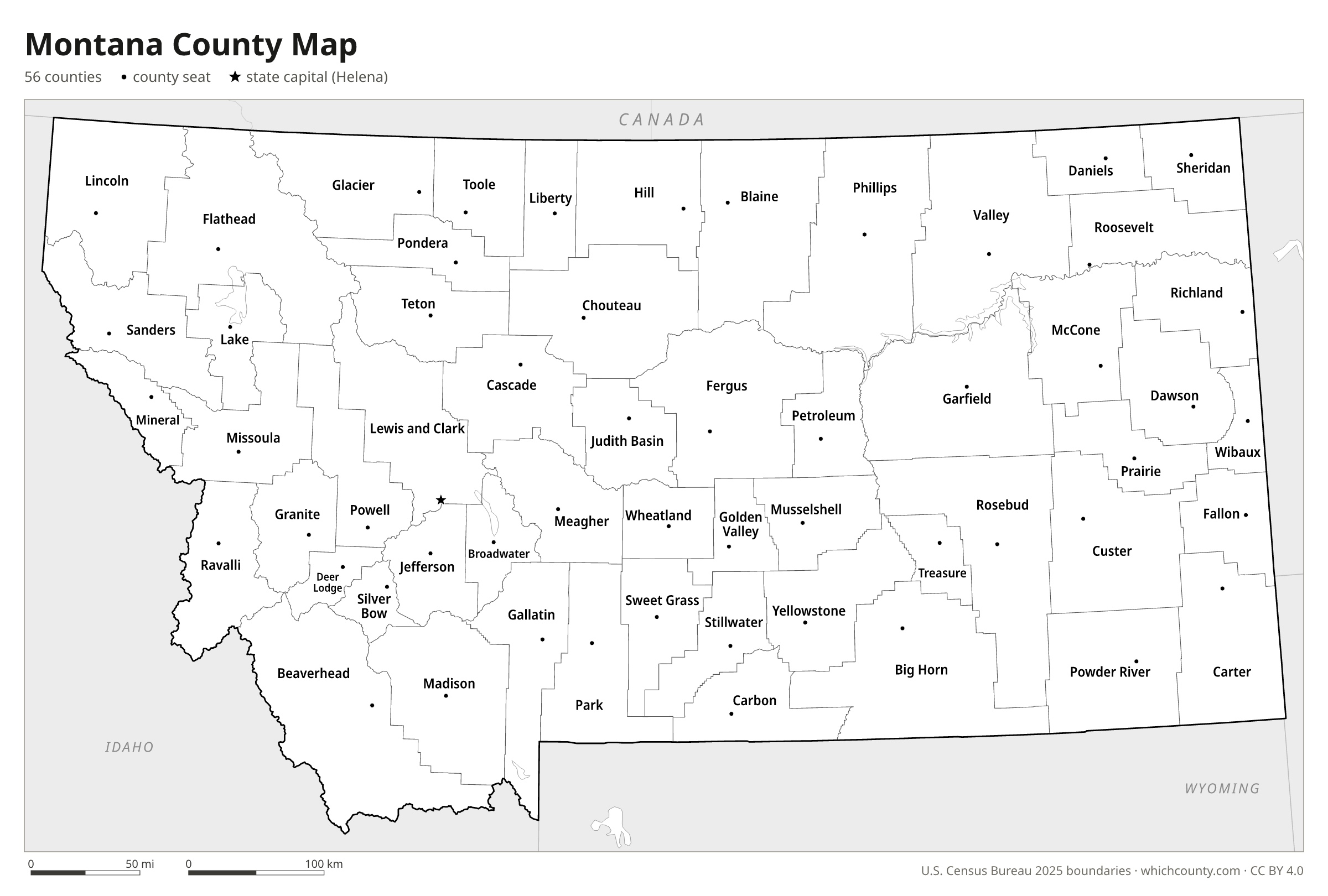
All 56 counties with county seats and major cities
Montana has 56 counties, more than twice the 27 it had before the county-splitting craze of the 1910s. This map shows all 56 counties and their county seats. Tap a county for details, or download the free printable map below.

Updated October 4, 2026 · Boundaries: U.S. Census Bureau 2025 · Population: Census estimates for July 1, 2025
Montana county facts
- Number of counties
- 56
- Largest by land area
- Beaverhead County 5,543 sq mi
- Smallest by land area
- Silver Bow County 718 sq mi
- Most people
- Yellowstone County 172,692
- Fewest people
- Petroleum County 548
- Fastest growing since 2020
- Broadwater County +25.4%
- Highest median household income
- Jefferson County $95,490
- Oldest county
- Beaverhead County est. 1865
- Newest county
- Petroleum County est. 1925
- State capital
- Helena Lewis and Clark County
The Montana part of Yellowstone National Park was a separate county-equivalent in Census data until November 7, 1997, when it was annexed to Gallatin and Park counties.
List of 56 Montana counties
Sorted A–Z. Click a column to sort, or a name to show it on the map. Download as CSV
| County | County seat | Population 2025 | Change since 2020 | Land area (sq mi) | Median income | Established | FIPS |
|---|---|---|---|---|---|---|---|
| Beaverhead County | Dillon | 10,043 | +7.2% | 5,543 | $61,268 | 1865 | 30001 |
| Big Horn County | Hardin | 12,752 | −2.8% | 4,998 | $58,750 | 1913 | 30003 |
| Blaine County | Chinook | 6,860 | −2.6% | 4,228 | $64,813 | 1912 | 30005 |
| Broadwater County | Townsend | 8,493 | +25.4% | 1,192 | $70,374 | 1897 | 30007 |
| Carbon County | Red Lodge | 11,466 | +9.5% | 2,048 | $80,261 | 1895 | 30009 |
| Carter County | Ekalaka | 1,383 | −2.1% | 3,341 | $54,167 | 1917 | 30011 |
| Cascade County | Great Falls | 85,029 | +0.7% | 2,698 | $67,690 | 1887 | 30013 |
| Chouteau County | Fort Benton | 5,865 | −0.8% | 3,973 | $58,218 | 1865 | 30015 |
| Custer County | Miles City | 12,034 | +1.5% | 3,783 | $70,605 | 1865 | 30017 |
| Daniels County | Scobey | 1,612 | −2.5% | 1,426 | $55,625 | 1920 | 30019 |
| Dawson County | Glendive | 8,692 | −2.8% | 2,372 | $71,334 | 1869 | 30021 |
| Deer Lodge County | Anaconda | 9,709 | +3% | 737 | $57,527 | 1865 | 30023 |
| Fallon County | Baker | 2,959 | −3% | 1,621 | $76,250 | 1913 | 30025 |
| Fergus County | Lewistown | 11,825 | +3.3% | 4,339 | $63,706 | 1885 | 30027 |
| Flathead County | Kalispell | 115,429 | +10.6% | 5,087 | $73,925 | 1893 | 30029 |
| Gallatin County | Bozeman | 128,740 | +8.2% | 2,605 | $93,528 | 1865 | 30031 |
| Garfield County | Jordan | 1,148 | −1.9% | 4,677 | $69,583 | 1919 | 30033 |
| Glacier County | Cut Bank | 13,463 | −2.3% | 2,995 | $46,875 | 1919 | 30035 |
| Golden Valley County | Ryegate | 844 | +2.2% | 1,174 | $58,333 | 1920 | 30037 |
| Granite County | Philipsburg | 3,658 | +10.8% | 1,727 | $59,265 | 1893 | 30039 |
| Hill County | Havre | 16,167 | −0.7% | 2,899 | $52,798 | 1912 | 30041 |
| Jefferson County | Boulder | 13,329 | +10.3% | 1,657 | $95,490 | 1865 | 30043 |
| Judith Basin County | Stanford | 2,162 | +7% | 1,870 | $59,000 | 1920 | 30045 |
| Lake County | Polson | 33,392 | +7.3% | 1,491 | $63,360 | 1923 | 30047 |
| Lewis and Clark County | Helena | 75,331 | +6.1% | 3,458 | $78,237 | 1865 | 30049 |
| Liberty County | Chester | 1,957 | −0.1% | 1,430 | $57,857 | 1920 | 30051 |
| Lincoln County | Libby | 22,328 | +13.5% | 3,613 | $47,143 | 1909 | 30053 |
| Madison County | Virginia City | 10,026 | +16.3% | 3,588 | $75,250 | 1865 | 30057 |
| McCone County | Circle | 1,720 | −0.5% | 2,642 | $69,375 | 1919 | 30055 |
| Meagher County | White Sulphur Springs | 2,137 | +11% | 2,392 | $71,932 | 1867 | 30059 |
| Mineral County | Superior | 5,185 | +14.5% | 1,220 | $63,450 | 1914 | 30061 |
| Missoula County | Missoula | 123,513 | +4.7% | 2,593 | $75,598 | 1865 | 30063 |
| Musselshell County | Roundup | 5,582 | +17.9% | 1,869 | $58,920 | 1911 | 30065 |
| Park County | Livingston | 18,214 | +5.9% | 2,803 | $70,047 | 1887 | 30067 |
| Petroleum County | Winnett | 548 | +10% | 1,656 | $60,208 | 1925 | 30069 |
| Phillips County | Malta | 4,203 | −0.3% | 5,140 | $53,417 | 1915 | 30071 |
| Pondera County | Conrad | 6,072 | +2.8% | 1,625 | $52,338 | 1919 | 30073 |
| Powder River County | Broadus | 1,781 | +5.1% | 3,298 | $67,045 | 1919 | 30075 |
| Powell County | Deer Lodge | 7,157 | +3.1% | 2,326 | $66,923 | 1901 | 30077 |
| Prairie County | Terry | 1,112 | +1.7% | 1,737 | $51,250 | 1915 | 30079 |
| Ravalli County | Hamilton | 48,582 | +10% | 2,391 | $71,283 | 1893 | 30081 |
| Richland County | Sidney | 11,377 | −1% | 2,085 | $73,084 | 1914 | 30083 |
| Roosevelt County | Wolf Point | 10,242 | −5.2% | 2,355 | $57,063 | 1919 | 30085 |
| Rosebud County | Forsyth | 8,253 | −1% | 5,008 | $49,914 | 1901 | 30087 |
| Sanders County | Thompson Falls | 14,062 | +13.5% | 2,760 | $57,476 | 1905 | 30089 |
| Sheridan County | Plentywood | 3,436 | −3.1% | 1,677 | $70,147 | 1913 | 30091 |
| Silver Bow County | Butte | 36,118 | +2.8% | 718 | $61,754 | 1881 | 30093 |
| Stillwater County | Columbus | 9,445 | +5.4% | 1,797 | $84,732 | 1913 | 30095 |
| Sweet Grass County | Big Timber | 3,762 | +2.2% | 1,856 | $77,000 | 1895 | 30097 |
| Teton County | Choteau | 6,496 | +4.3% | 2,272 | $70,430 | 1893 | 30099 |
| Toole County | Shelby | 5,211 | +4.9% | 1,915 | $57,731 | 1914 | 30101 |
| Treasure County | Hysham | 728 | −4.2% | 978 | $67,917 | 1919 | 30103 |
| Valley County | Glasgow | 7,385 | −2.6% | 4,926 | $71,695 | 1893 | 30105 |
| Wheatland County | Harlowton | 2,100 | +1.5% | 1,423 | $49,489 | 1917 | 30107 |
| Wibaux County | Wibaux | 885 | −5.6% | 890 | $67,462 | 1914 | 30109 |
| Yellowstone County | Billings | 172,692 | +4.8% | 2,633 | $76,570 | 1883 | 30111 |
Montana county map with cities
The largest cities in Montana and the counties they are in. Cities that cross a county line list every county, the main one first. To find any smaller town, use the search box above.
| City | County | Population 2025 |
|---|---|---|
| Billings | Yellowstone County | 121,239 |
| Missoula | Missoula County | 78,903 |
| Great Falls | Cascade County | 60,208 |
| Bozeman | Gallatin County | 58,814 |
| Butte | Silver Bow County | 35,469 |
| Helena | Lewis and Clark County | 35,138 |
| Kalispell | Flathead County | 31,851 |
| Belgrade | Gallatin County | 13,107 |
| Anaconda | Deer Lodge County | 9,709 |
| Whitefish | Flathead County | 9,358 |
| Livingston | Park County | 9,290 |
| Havre | Hill County | 9,264 |
| Miles City | Custer County | 8,450 |
| Laurel | Yellowstone County | 7,205 |
| Sidney | Richland County | 6,217 |
| Lewistown | Fergus County | 6,179 |
| Columbia Falls | Flathead County | 5,753 |
| Polson | Lake County | 5,653 |
| Hamilton | Ravalli County | 5,451 |
| Glendive | Dawson County | 4,736 |
| Dillon | Beaverhead County | 4,271 |
| Hardin | Big Horn County | 3,696 |
| Shelby | Toole County | 3,313 |
| Libby | Lincoln County | 3,274 |
| Glasgow | Valley County | 3,145 |
| Deer Lodge | Powell County | 3,025 |
| Cut Bank | Glacier County | 2,976 |
| Red Lodge | Carbon County | 2,723 |
| Wolf Point | Roosevelt County | 2,531 |
| Conrad | Pondera County | 2,393 |
Printable Montana county maps (free PDF, PNG, SVG)
Every map is free to print and share. The PDFs are vector files with real text, so they stay sharp at any size and you can search them for a county name. Use 11×17 (tabloid) for the most readable labels.
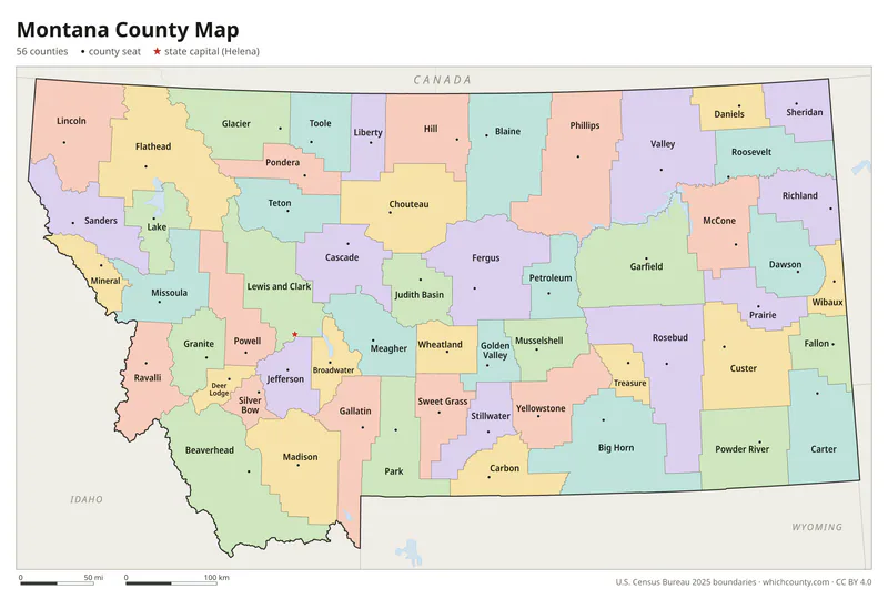
Color map with names
All 56 counties labeled, county seats marked. Letter and 11×17 PDF, high-resolution PNG, editable SVG.
Map with cities
Counties with their county seat towns and major cities.
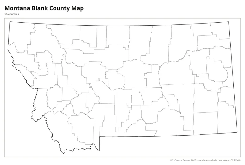
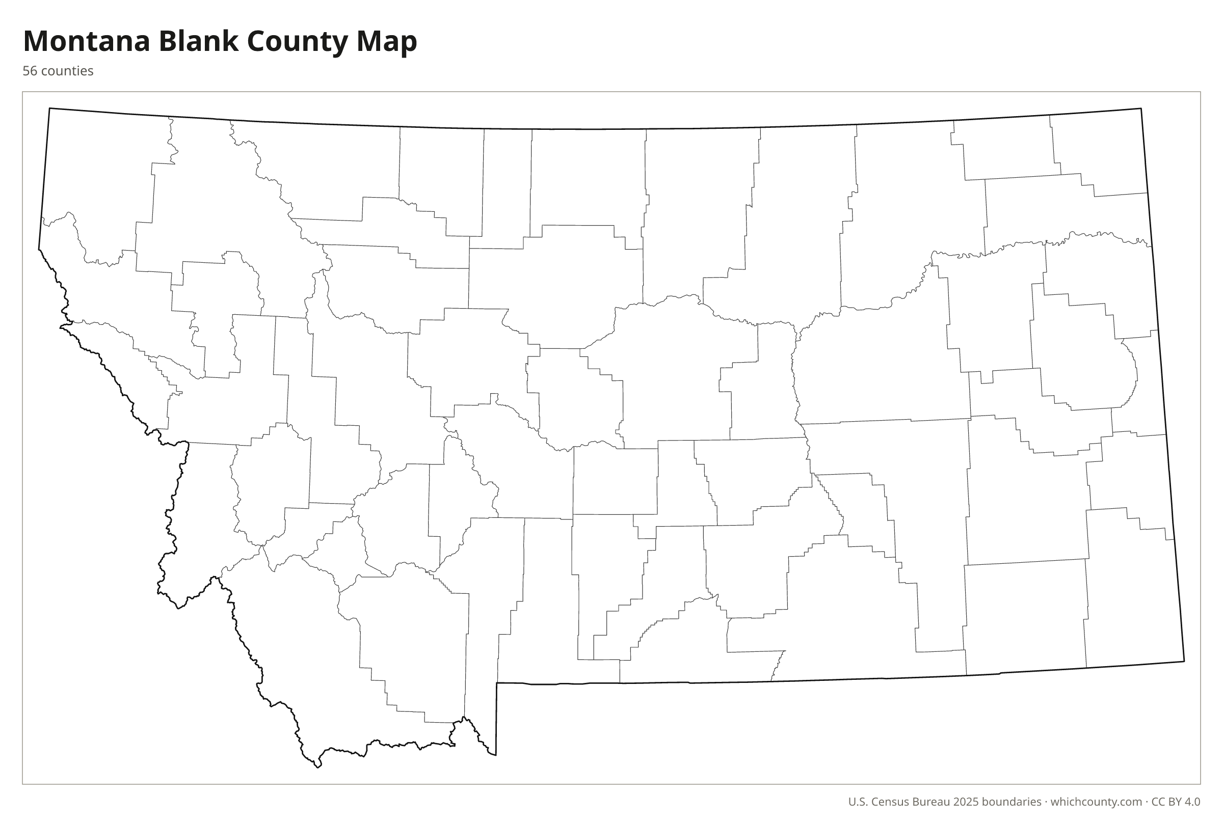
Blank outline map
County lines only, no names. For quizzes, coloring and your own notes.
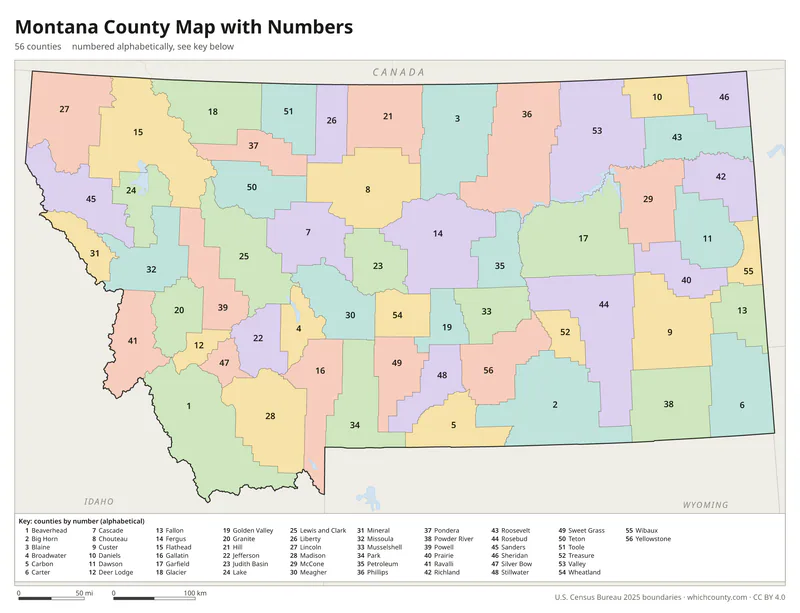
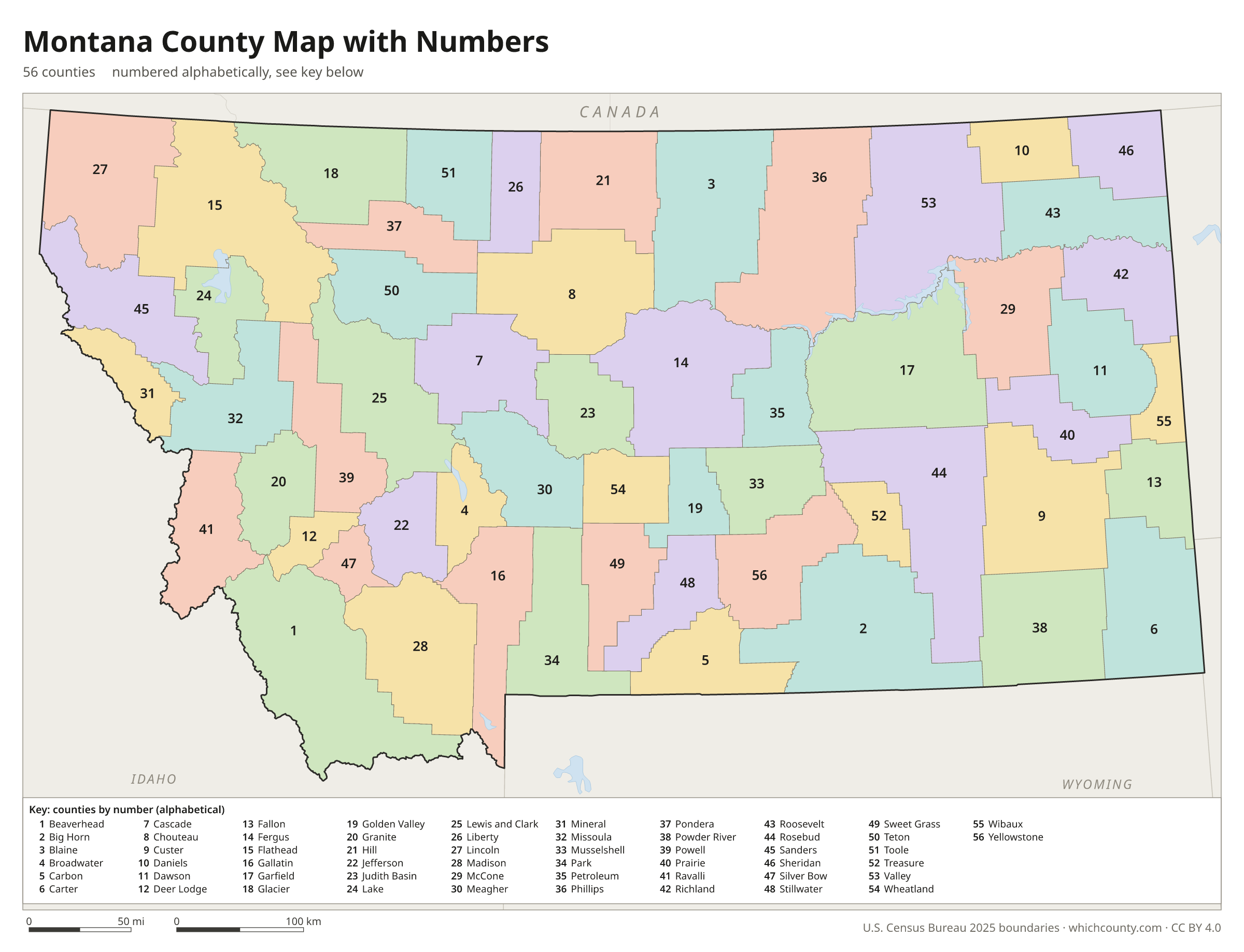
Numbered map with key
A number in every county with an alphabetical key.
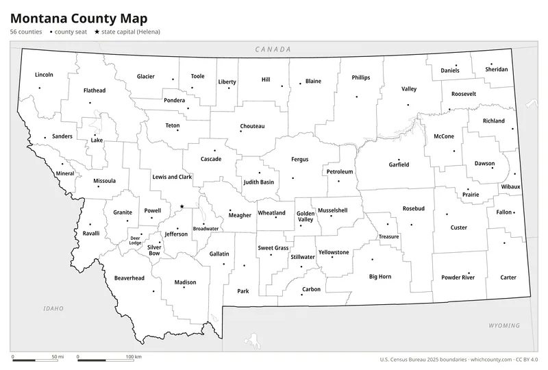
Black and white
Labeled map that prints well on any printer.
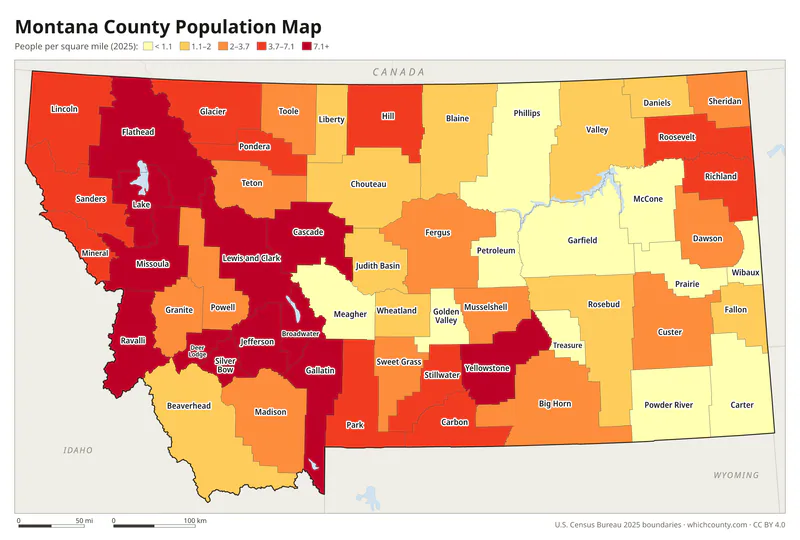
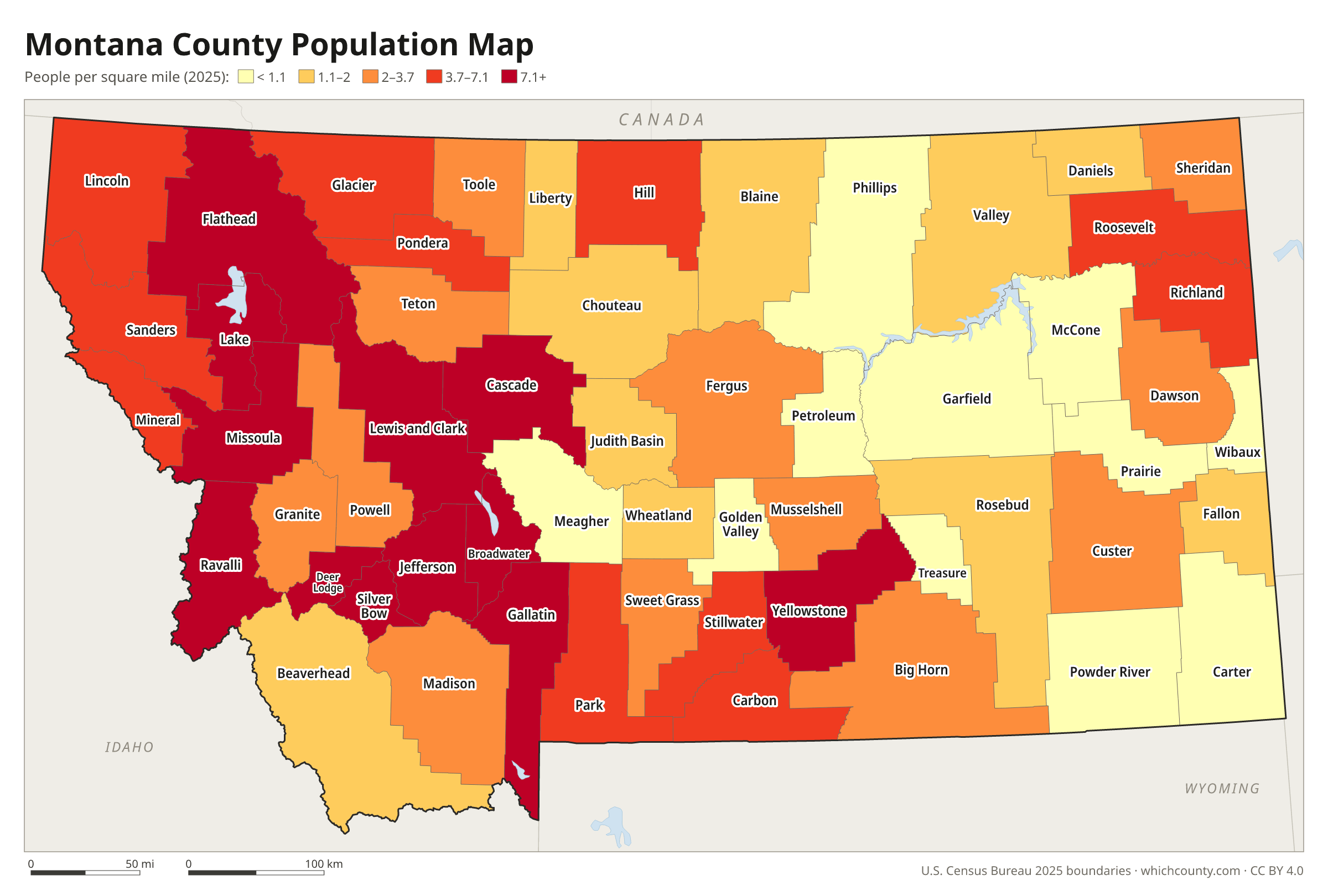
Population map
Counties shaded by population density (2025 estimates).
Data and GIS files
The county table as CSV, and the boundaries as GeoJSON and KML (Google Earth, Google My Maps).
Why Montana has 56 counties
Montana Territory began with nine counties in 1865, and the state still had only 27 when homesteaders poured into the eastern plains in the 1910s. The newcomers wanted local government closer to home. A county seat brought courts, filing offices and jobs, and since each county then elected its own state senator, more rural counties gave farmers a stronger voice in the legislature. In 1915 the legislature passed a law that let residents redraw county lines by petition. Within a few years the 27 counties had split into 56, a fad known as county-busting. Petroleum County, carved from Fergus County by petition and election in 1925, was the last. Many of the small counties have struggled since. Nearly every legislature since 1936 has considered combining some of them, but residents have refused to give up their county seats.
County maps of neighboring states
 Idaho county map
 North Dakota county map
 South Dakota county map
 Wyoming county map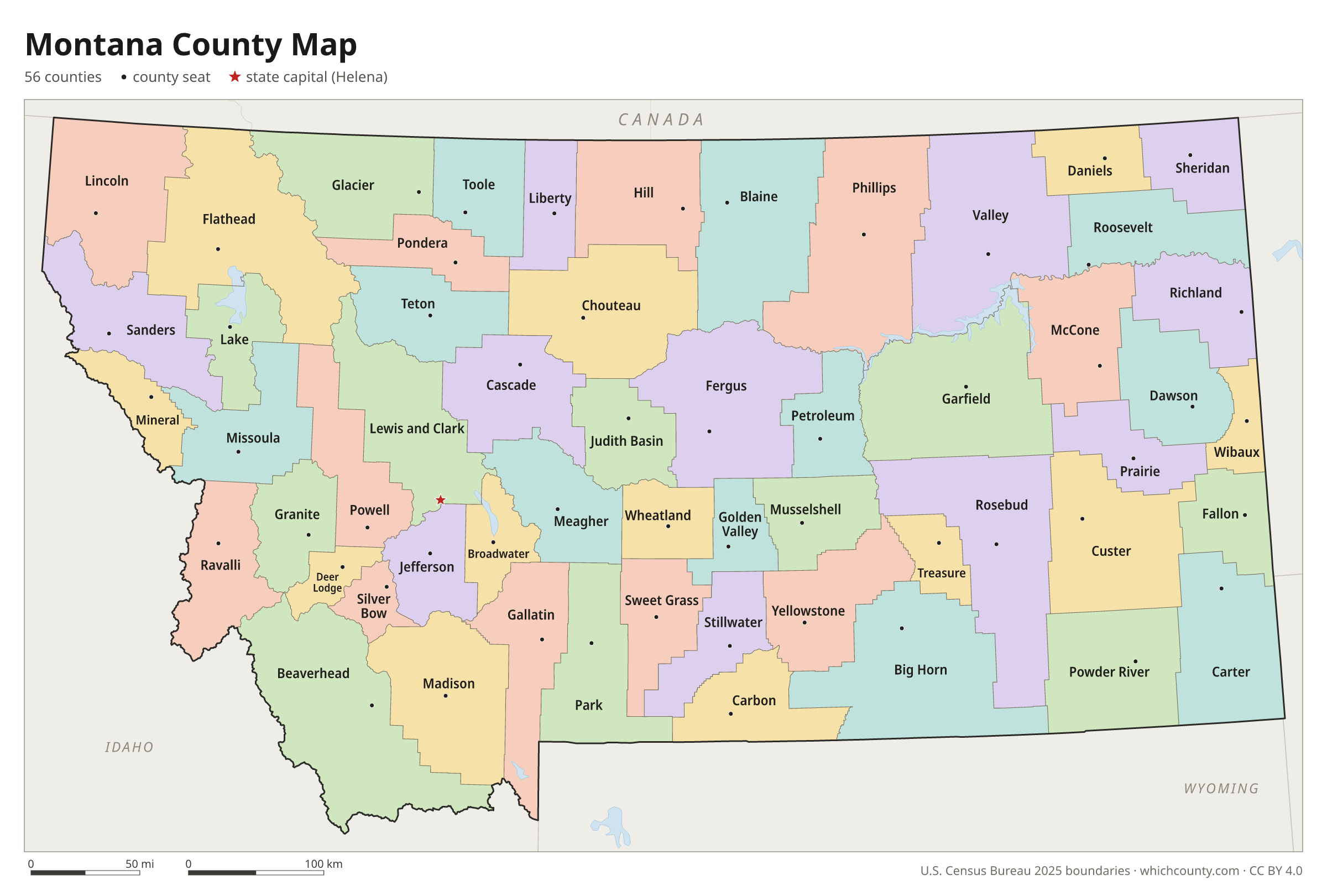
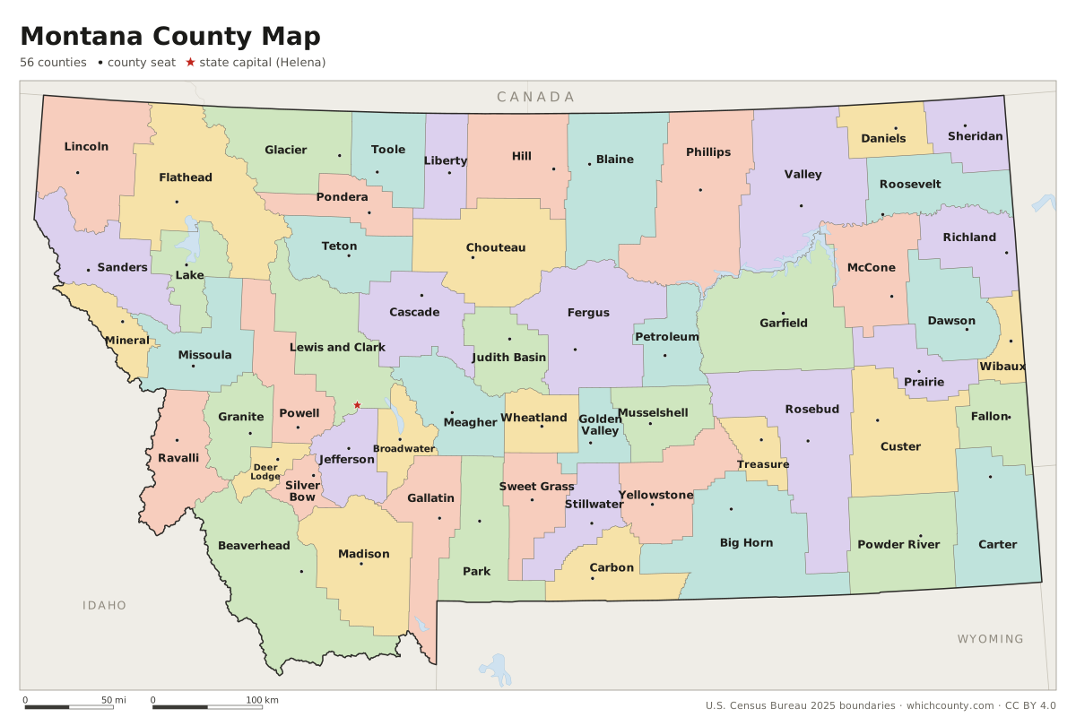
Montana counties: questions and answers
- How many counties are in Montana?
- Montana has 56 counties.
- What is the largest county in Montana?
- By land area, Beaverhead County is the largest (5,543 sq mi). By population, Yellowstone County is the largest, with 172,692 people (2025 estimate).
- What is the smallest county in Montana?
- Silver Bow County is the smallest by land area (718 sq mi). Petroleum County has the fewest people: 548 (2025 estimate).
- What is the wealthiest county in Montana?
- By median household income, Jefferson County ranks first with $95,490 (American Community Survey 2020–2024). The lowest is Glacier County at $46,875.
- What county is Billings in?
- Billings is in Yellowstone County.
- What county is Missoula in?
- Missoula is in Missoula County.
- What county is Great Falls in?
- Great Falls is in Cascade County.
- What county is Helena in?
- Helena, the state capital, is in Lewis and Clark County.
- How can I see county lines on Google Maps?
- Google Maps does not draw county lines. Download the KML file from the printable maps section above and import it into Google My Maps (Create a new map › Import) or open it in Google Earth to see every Montana county boundary on top of Google's map.
- Can I use this map for free?
- Yes. The maps and files on this page are free to print, share and use in your own work, including commercial projects, under the CC BY 4.0 licence. Please credit “WhichCounty (whichcounty.com)”.
Use this map on your site
You may copy, print and publish these maps, also commercially, as long as you credit WhichCounty with a link (licence details). Paste this code to embed the map:
Sources and methodology
- Boundaries: U.S. Census Bureau, 2025 Cartographic Boundary Files (1:500,000), simplified for display. Projection: Lambert conformal conic fitted to Montana.
- Population: Census Bureau county estimates, Vintage 2025 (July 1, 2025), compared with the April 1, 2020 estimates base.
- Land area: Census Bureau 2026 Gazetteer files. Median household income: American Community Survey 2020–2024 5-year estimates.
- County seats and founding years: Wikidata (CC0), checked against state lists by WhichCounty. Cities: Census Bureau city and town estimates, Vintage 2025.
- Montana: Stories of the Land, Chapter 15: Progressive Montana (Montana Historical Society)
- Montana: Stories of the Land, Chapter 13: Homesteading This Dry Land (Montana Historical Society)
- Atlas of Historical County Boundaries: Montana (Newberry Library)
- Substantial Changes to Counties and County Equivalent Entities: 1990s (U.S. Census Bureau)
Found an error? Tell us. Last data update: October 4, 2026.