Gila County, Arizona
County seat: Globe · Population 53,801 (2025) · 4,758 sq mi
Gila County is the 11th most populous of Arizona's 15 counties, with 53,801 people (2025 estimate). Its county seat is Globe. The map shows its 6 cities and towns and the 6 neighboring counties.

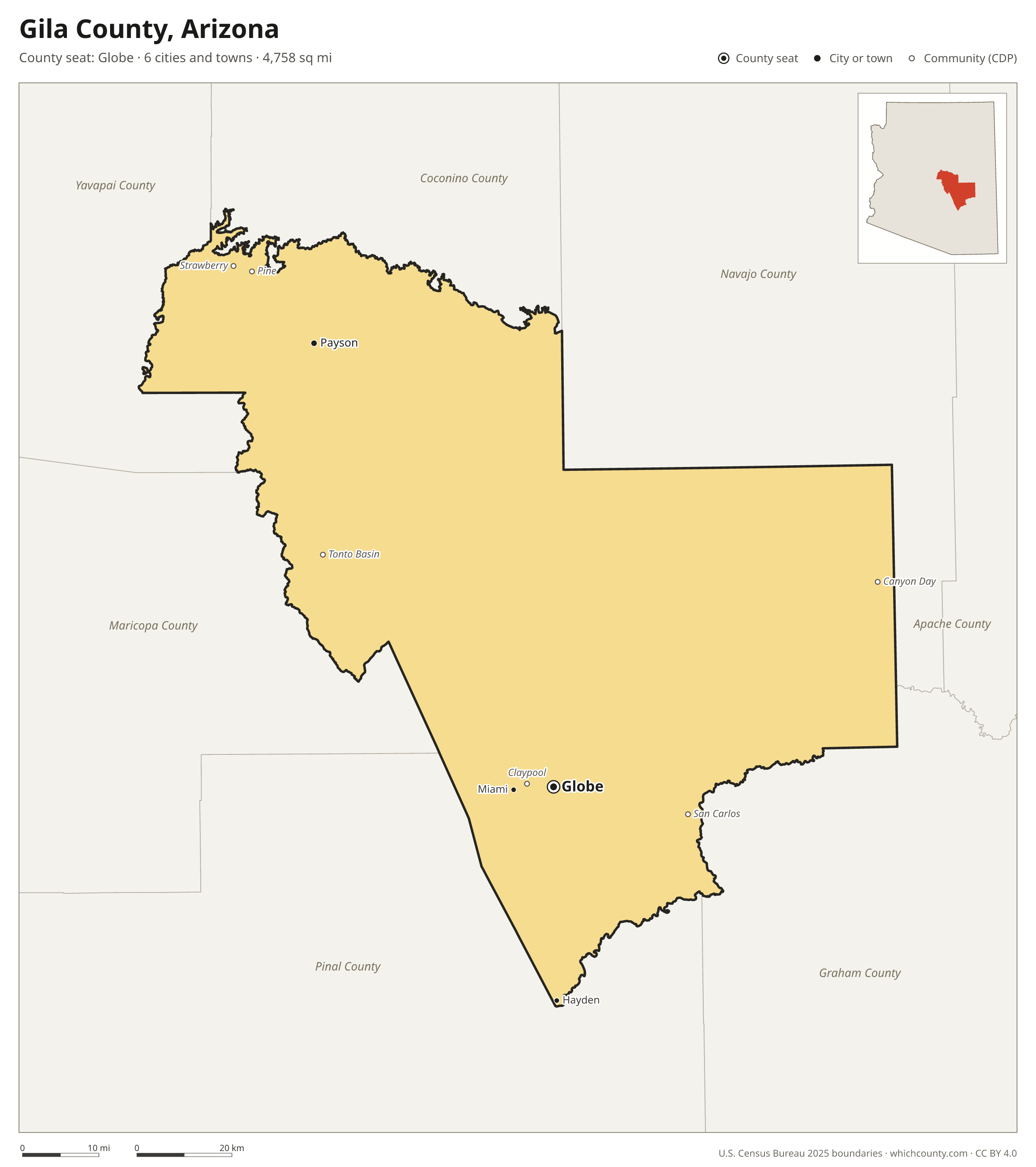
Gila County facts
- County seat
- Globe
- Population (2025 estimate)
- 53,801 +1% since 2020
- Land area
- 4,758 sq mi 11th largest of 15
- Water area
- 37 sq mi
- Population density
- 11 per sq mi
- Established
- 1881
- Named after
- Gila River river in Arizona and New Mexico in the United States
- Largest city
- Payson 16,693
- Median household income
- $61,986
- Cities and towns
- 6 plus 45 CDPs
- ZIP codes
- 14
- Time zone
- Mountain (no DST)
- FIPS code
- 04007
Cities and towns in Gila County
Gila County has 6 incorporated cities, towns and villages. Populations count the people living inside Gila County; cities that cross a county line also list the other counties.
| Name | Type | Population 2025 | Also in |
|---|---|---|---|
| Payson | Town | 16,693 | |
| Globe (county seat) | City | 7,191 | |
| Star Valley | Town | 2,538 | |
| Miami | Town | 1,514 | |
| Hayden | Town | 510 | Pinal County |
| Winkelman | Town | 288 | Pinal County |
Unincorporated communities (CDPs)
Census-designated places are communities without their own city government; the county provides their services.
| Community | Population | Also in |
|---|---|---|
| San Carlos | 4,973 | |
| Central Heights-Midland City | 2,909 | |
| Tonto Basin | 1,750 | |
| Pine | 1,740 | |
| Claypool | 1,259 | |
| Canyon Day | 1,182 | |
| Strawberry | 1,094 | |
| Mesa del Caballo | 944 | |
| Six Shooter Canyon | 811 | |
| Round Valley | 631 | |
| Roosevelt Estates | 593 | |
| Gisela | 587 | |
| Icehouse Canyon | 528 | |
| Pinal | 460 | |
| Cedar Creek | 398 | |
| Peridot | 345 | Graham County |
| Wheatfields | 329 | |
| East Verde Estates | 275 | |
| Carrizo | 249 | |
| Deer Creek | 242 | |
| Young | 236 | |
| East Globe | 224 | |
| Mead Ranch | 218 | |
| Dripping Springs | 186 | |
| Copper Hill | 163 | |
| Kohls Ranch | 161 | |
| Whispering Pines | 151 | |
| Tonto Village | 123 | |
| Jakes Corner | 111 | |
| Cutter | 103 | |
| Christopher Creek | 88 | |
| Beaver Valley | 74 | |
| Geronimo Estates | 68 | |
| Freedom Acres | 48 | |
| Hunter Creek | 45 | |
| Oxbow Estates | 44 | |
| Flowing Springs | 38 | |
| El Capitan | 28 | |
| Rye | 17 | |
| Washington Park | 10 | |
| Rock House | 8 | |
| Bear Flat | 0 | |
| Haigler Creek | 0 | |
| Roosevelt | 0 | |
| Top-of-the-World | 0 | Pinal County |
ZIP codes in Gila County
14 ZIP codes reach into Gila County. ZIP codes ignore county lines, so some also cover a neighboring county.
- 85135
- 85192 also Pinal County
- 85264 also Maricopa County
- 85501
- 85532
- 85539 also Pinal County
- 85541
- 85542 also Graham County
- 85544
- 85545 also Maricopa County
- 85550
- 85553
- 85554
- 85941 also Navajo County
Population of Gila County, 2020–2025
Gila County grew by 533 people (+1%) between April 2020 and July 2025: 2,510 more deaths than births and a net gain of 3,056 people from migration.
| Year (July 1) | Population |
|---|---|
| 2020 | 53,338 |
| 2021 | 53,522 |
| 2022 | 53,902 |
| 2023 | 54,040 |
| 2024 | 54,126 |
| 2025 | 53,801 |
Neighboring counties
- Coconino County north · 144,368 people
- Navajo County north · 109,946 people
- Pinal County southwest · 539,380 people
- Maricopa County west · 4,689,558 people
- Yavapai County northwest · 252,552 people
- Graham County southeast · 40,157 people
Printable Gila County map
The PDF is a vector file with real text: it prints sharp on Letter paper and you can search it for a town. The PNG is 2400 pixels wide for slides and documents. Both are free to use with a credit to WhichCounty.
- PDF (Letter) (149 KB)
- PNG (2400 px) (92 KB)
Paste this code to embed the map on your site:
Sources
- Boundaries: U.S. Census Bureau, 2025 Cartographic Boundary Files (1:500,000).
- Population: Census Bureau county and city estimates, Vintage 2025. CDP populations: American Community Survey 2020–2024.
- Places and ZIP codes: Census Bureau 2026 Gazetteer and 2020 ZIP Code Tabulation Area relationship files.
- County seat, founding year and name origin: Wikidata (CC0), checked against state sources.
Back to the Arizona county map with all 15 counties. Found an error? Tell us.