Mohave County, Arizona
County seat: Kingman · Population 228,102 (2025) · 13,332 sq mi
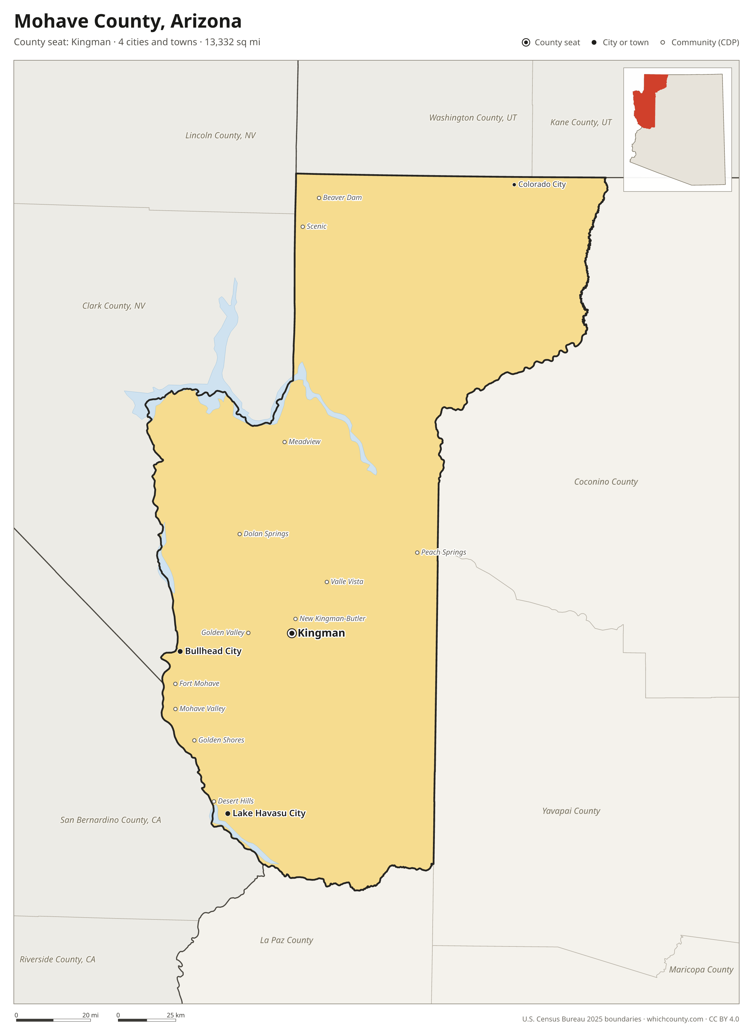
Mohave County is the 5th most populous of Arizona's 15 counties, with 228,102 people (2025 estimate). Its county seat is Kingman. The map shows its 4 cities and towns and the 8 neighboring counties.

Mohave County facts
- County seat
- Kingman
- Population (2025 estimate)
- 228,102 +7% since 2020
- Land area
- 13,332 sq mi 2nd largest of 15
- Water area
- 129 sq mi
- Population density
- 17 per sq mi
- Established
- 1864
- Named after
- Mojave people Native American people from the southwestern United States
- Largest city
- Lake Havasu City 59,358
- Median household income
- $57,684
- Cities and towns
- 4 plus 42 CDPs
- ZIP codes
- 25
- Time zone
- Mountain (no DST)
- FIPS code
- 04015
Cities and towns in Mohave County
Mohave County has 4 incorporated cities, towns and villages. Populations count the people living inside Mohave County; cities that cross a county line also list the other counties.
| Name | Type | Population 2025 | Also in |
|---|---|---|---|
| Lake Havasu City | City | 59,358 | |
| Bullhead City | City | 43,987 | |
| Kingman (county seat) | City | 35,829 | |
| Colorado City | Town | 3,484 |
Unincorporated communities (CDPs)
Census-designated places are communities without their own city government; the county provides their services.
| Community | Population | Also in |
|---|---|---|
| Fort Mohave | 15,715 | |
| New Kingman-Butler | 13,993 | |
| Golden Valley | 8,567 | |
| Desert Hills | 2,944 | |
| Mohave Valley | 2,555 | |
| Valle Vista | 2,369 | |
| Centennial Park | 1,839 | |
| Beaver Dam | 1,624 | |
| Golden Shores | 1,555 | |
| Meadview | 1,517 | |
| Scenic | 1,379 | |
| Dolan Springs | 1,341 | |
| Peach Springs | 1,234 | |
| Willow Valley | 981 | |
| Arizona Village | 713 | |
| So-Hi | 648 | |
| Cane Beds | 637 | |
| Walnut Creek | 556 | |
| Mesquite Creek | 548 | |
| Lazy Y U | 481 | |
| Hackberry | 338 | |
| Crystal Beach | 299 | |
| White Hills | 286 | |
| Pinion Pines | 221 | |
| Katherine | 159 | |
| Truxton | 134 | |
| Antares | 110 | |
| Kaibab | 105 | |
| Pine Lake | 98 | |
| Wikieup | 92 | |
| Chloride | 75 | |
| Yucca | 75 | |
| Oatman | 74 | |
| Littlefield | 70 | |
| Clacks Canyon | 59 | |
| Mojave Ranch Estates | 46 | |
| Valentine | 25 | |
| Crozier | 5 | |
| Grand Canyon West | 0 | |
| McConnico | 0 | |
| Moccasin | 0 | |
| Topock | 0 |
ZIP codes in Mohave County
25 ZIP codes reach into Mohave County. ZIP codes ignore county lines, so some also cover a neighboring county.
- 85360
- 86021
- 86022 also Coconino County
- 86401
- 86403
- 86404
- 86406
- 86409
- 86411
- 86413
- 86426
- 86429
- 86431
- 86432
- 86433
- 86434 also Yavapai and Coconino counties
- 86436
- 86437
- 86438
- 86440
- 86441
- 86442
- 86443
- 86444
- 86445
Population of Mohave County, 2020–2025
Mohave County grew by 14,841 people (+7%) between April 2020 and July 2025: 12,640 more deaths than births and a net gain of 27,421 people from migration.
| Year (July 1) | Population |
|---|---|
| 2020 | 214,167 |
| 2021 | 217,232 |
| 2022 | 220,791 |
| 2023 | 223,586 |
| 2024 | 226,262 |
| 2025 | 228,102 |
Neighboring counties
- Clark County, Nevada northwest · 2,407,226 people
- Coconino County east · 144,368 people
- Yavapai County southeast · 252,552 people
- San Bernardino County, California southwest · 2,224,091 people
- Washington County, Utah north · 213,670 people
- La Paz County south · 16,711 people
- Kane County, Utah northeast · 8,597 people
- Lincoln County, Nevada northwest · 4,320 people
Printable Mohave County map
The PDF is a vector file with real text: it prints sharp on Letter paper and you can search it for a town. The PNG is 2400 pixels wide for slides and documents. Both are free to use with a credit to WhichCounty.
- PDF (Letter) (183 KB)
- PNG (2400 px) (135 KB)
Paste this code to embed the map on your site:
Sources
- Boundaries: U.S. Census Bureau, 2025 Cartographic Boundary Files (1:500,000).
- Population: Census Bureau county and city estimates, Vintage 2025. CDP populations: American Community Survey 2020–2024.
- Places and ZIP codes: Census Bureau 2026 Gazetteer and 2020 ZIP Code Tabulation Area relationship files.
- County seat, founding year and name origin: Wikidata (CC0), checked against state sources.
Back to the Arizona county map with all 15 counties. Found an error? Tell us.