Pima County, Arizona
County seat: Tucson · Population 1.1 million (2025) · 9,189 sq mi
Pima County is the 2nd most populous of Arizona's 15 counties, with 1,074,685 people (2025 estimate). Its county seat is Tucson. The map shows its 5 cities and towns and the 6 neighboring counties.

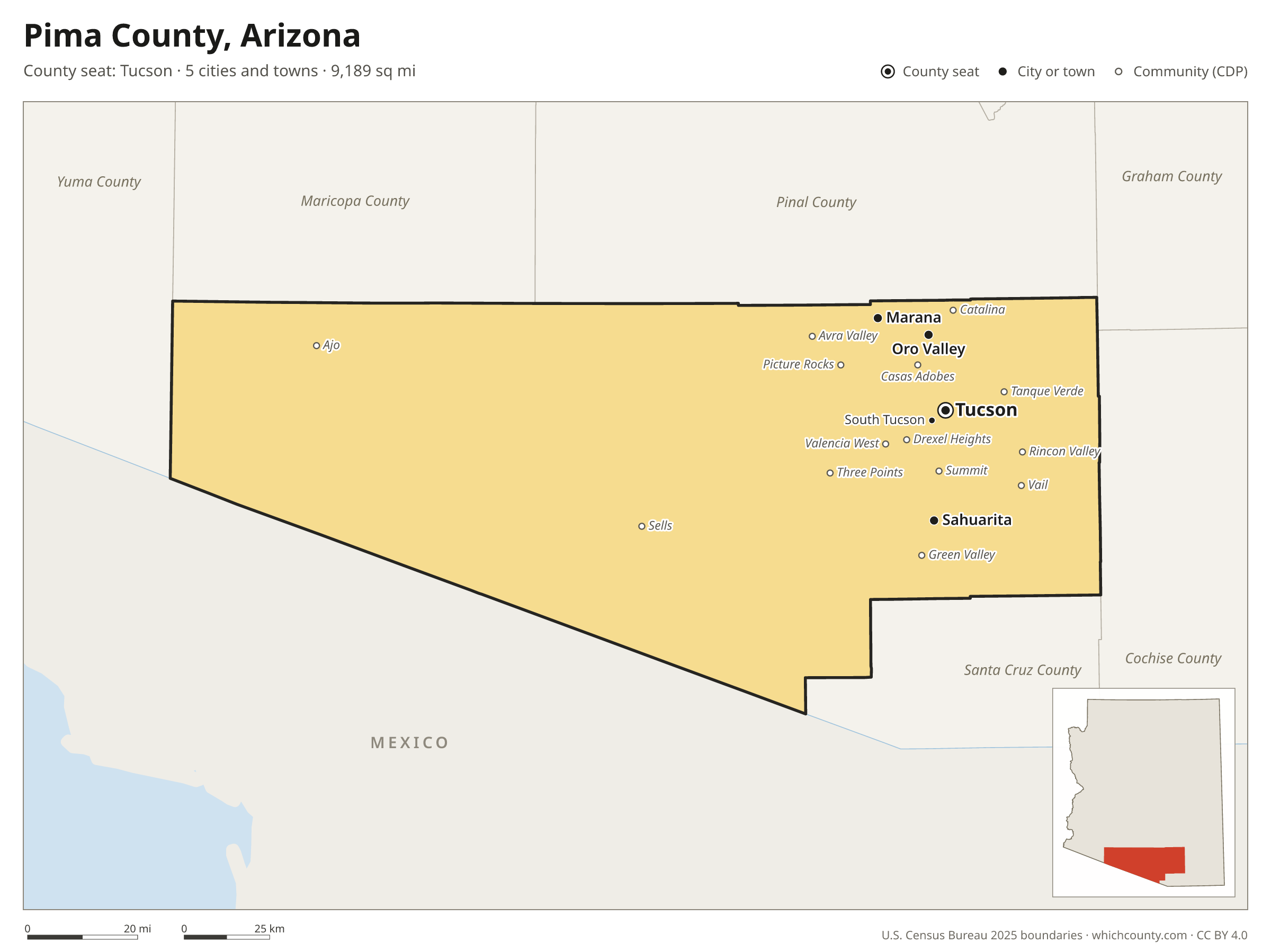
Pima County facts
- County seat
- Tucson
- Population (2025 estimate)
- 1,074,685 +3% since 2020
- Land area
- 9,189 sq mi 6th largest of 15
- Water area
- 2 sq mi
- Population density
- 117 per sq mi
- Established
- 1864
- Named after
- Akimel O'odham Native American people
- Largest city
- Tucson 548,371
- Median household income
- $70,315
- Cities and towns
- 5 plus 50 CDPs
- ZIP codes
- 56
- Time zone
- Mountain (no DST)
- FIPS code
- 04019
Cities and towns in Pima County
Pima County has 5 incorporated cities, towns and villages. Populations count the people living inside Pima County; cities that cross a county line also list the other counties.
| Name | Type | Population 2025 | Also in |
|---|---|---|---|
| Tucson (county seat) | City | 548,371 | |
| Marana | Town | 65,523 | Pinal County |
| Oro Valley | Town | 48,085 | |
| Sahuarita | Town | 37,694 | |
| South Tucson | City | 4,452 |
Unincorporated communities (CDPs)
Census-designated places are communities without their own city government; the county provides their services.
| Community | Population | Also in |
|---|---|---|
| Casas Adobes | 72,059 | |
| Catalina Foothills | 52,593 | |
| Drexel Heights | 27,675 | |
| Green Valley | 22,114 | |
| Flowing Wells | 16,559 | |
| Vail | 16,315 | |
| Tanque Verde | 15,866 | |
| Valencia West | 14,728 | |
| Tucson Estates | 12,136 | |
| Tucson Mountains | 11,353 | |
| Corona de Tucson | 9,566 | |
| Picture Rocks | 9,448 | |
| Rincon Valley | 6,512 | |
| Catalina | 6,489 | |
| Avra Valley | 6,277 | |
| Three Points | 5,254 | |
| Summit | 4,896 | |
| Ajo | 3,107 | |
| Sells | 1,935 | |
| Arivaca Junction | 642 | |
| Santa Rosa | 615 | |
| Nelson | 519 | |
| Elephant Head | 481 | |
| J-Six Ranchettes | 419 | |
| Pisinemo | 311 | |
| Arivaca | 268 | |
| San Miguel | 237 | |
| Gu Oidak | 192 | |
| South Komelik | 178 | |
| Ali Molina | 171 | |
| Topawa | 166 | |
| Chiawuli Tak | 146 | |
| Wahak Hotrontk | 125 | |
| Haivana Nakya | 96 | |
| Anegam | 92 | |
| Ventana | 92 | |
| Ali Chukson | 77 | |
| Ko Vaya | 53 | |
| Kleindale | 52 | |
| Why | 52 | |
| Maish Vaya | 38 | |
| Cowlic | 25 | |
| Ak Chin | 22 | |
| Ali Chuk | 18 | |
| Charco | 7 | |
| Comobabi | 0 | |
| Nolic | 0 | |
| Rillito | 0 | |
| Summerhaven | 0 | |
| Willow Canyon | 0 |
ZIP codes in Pima County
56 ZIP codes reach into Pima County. ZIP codes ignore county lines, so some also cover a neighboring county.
- 85321 also Maricopa County
- 85341
- 85601
- 85602 also Cochise County
- 85611 also Santa Cruz and Cochise counties
- 85614 also Santa Cruz County
- 85619
- 85622
- 85629
- 85633
- 85634 also Pinal County
- 85637 also Santa Cruz County
- 85639
- 85641
- 85645 also Santa Cruz County
- 85653 also Pinal County
- 85654
- 85658 also Pinal County
- 85701
- 85704
- 85705
- 85706
- 85707
- 85708
- 85709
- 85710
- 85711
- 85712
- 85713
- 85714
- 85715
- 85716
- 85718
- 85719
- 85721
- 85723
- 85724
- 85726
- 85730
- 85734
- 85735
- 85736
- 85737
- 85739 also Pinal County
- 85741
- 85742
- 85743
- 85745
- 85746
- 85747
- 85748
- 85749
- 85750
- 85755
- 85756
- 85757
Population of Pima County, 2020–2025
Pima County grew by 31,254 people (+3%) between April 2020 and July 2025: 10,627 more deaths than births and a net gain of 41,221 people from migration.
| Year (July 1) | Population |
|---|---|
| 2020 | 1,045,245 |
| 2021 | 1,049,271 |
| 2022 | 1,058,224 |
| 2023 | 1,065,239 |
| 2024 | 1,073,456 |
| 2025 | 1,074,685 |
Neighboring counties
- Pinal County northeast · 539,380 people
- Santa Cruz County southeast · 50,020 people
- Maricopa County northwest · 4,689,558 people
- Cochise County east · 126,332 people
- Yuma County west · 224,449 people
- Graham County northeast · 40,157 people
Printable Pima County map
The PDF is a vector file with real text: it prints sharp on Letter paper and you can search it for a town. The PNG is 2400 pixels wide for slides and documents. Both are free to use with a credit to WhichCounty.
- PDF (Letter) (116 KB)
- PNG (2400 px) (75 KB)
Paste this code to embed the map on your site:
Sources
- Boundaries: U.S. Census Bureau, 2025 Cartographic Boundary Files (1:500,000).
- Population: Census Bureau county and city estimates, Vintage 2025. CDP populations: American Community Survey 2020–2024.
- Places and ZIP codes: Census Bureau 2026 Gazetteer and 2020 ZIP Code Tabulation Area relationship files.
- County seat, founding year and name origin: Wikidata (CC0), checked against state sources.
Back to the Arizona county map with all 15 counties. Found an error? Tell us.