Tulare County, California
County seat: Visalia · Population 485,146 (2025) · 4,824 sq mi
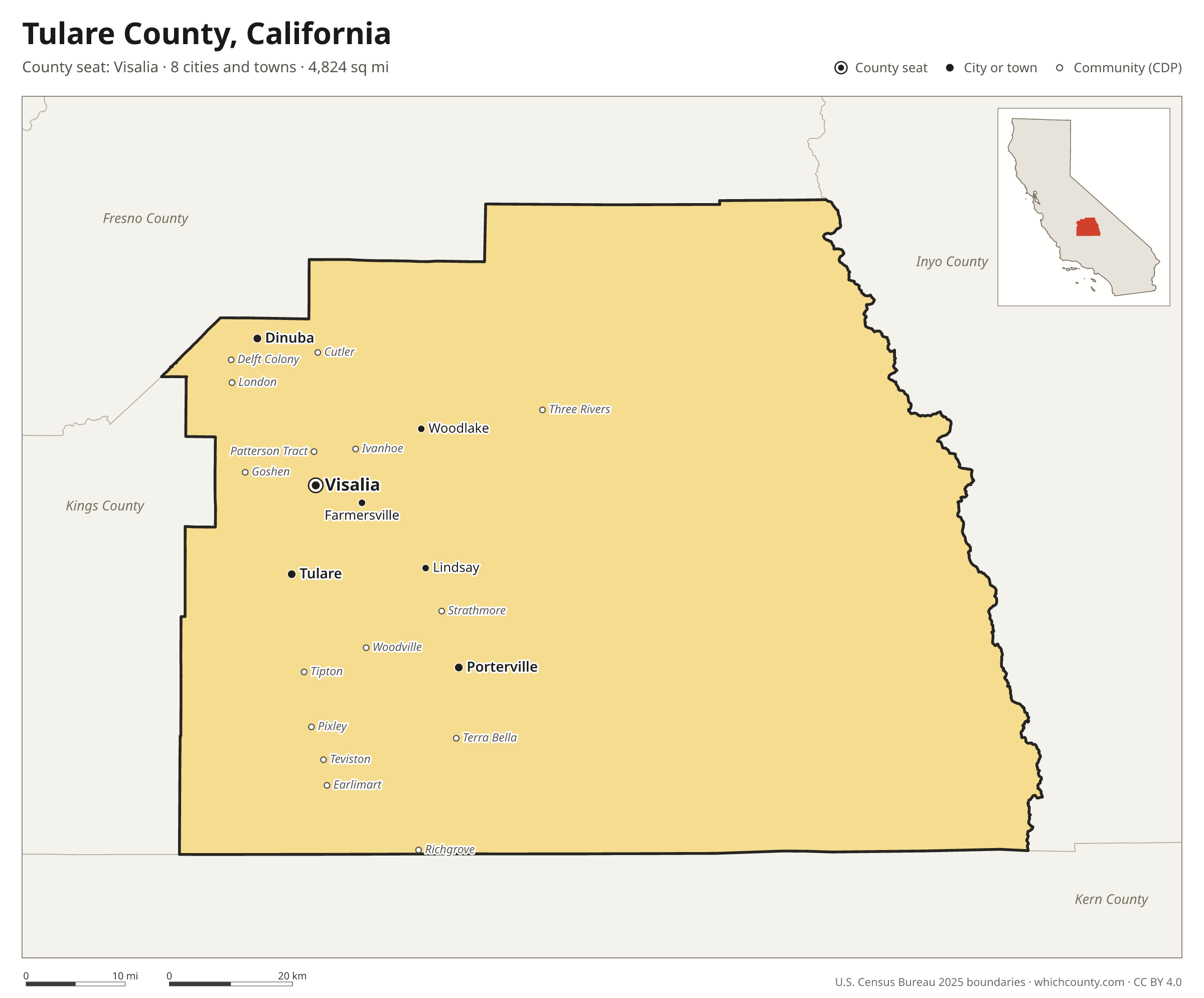
Tulare County is the 18th most populous of California's 58 counties, with 485,146 people (2025 estimate). Its county seat is Visalia. The map shows its 8 cities and towns and the 4 neighboring counties.

Tulare County facts
- County seat
- Visalia
- Population (2025 estimate)
- 485,146 +2.5% since 2020
- Land area
- 4,824 sq mi 7th largest of 58
- Water area
- 14 sq mi
- Population density
- 101 per sq mi
- Established
- 1852
- Named after
- Schoenoplectus acutus, Tulare Lake
- Largest city
- Visalia 146,541
- Median household income
- $71,300
- Cities and towns
- 8 plus 62 CDPs
- ZIP codes
- 45
- Time zone
- Pacific
- FIPS code
- 06107
Cities and towns in Tulare County
Tulare County has 8 incorporated cities, towns and villages. Populations count the people living inside Tulare County; cities that cross a county line also list the other counties.
| Name | Type | Population 2025 | Also in |
|---|---|---|---|
| Visalia (county seat) | City | 146,541 | |
| Tulare | City | 73,907 | |
| Porterville | City | 63,088 | |
| Dinuba | City | 25,949 | |
| Lindsay | City | 12,578 | |
| Farmersville | City | 10,326 | |
| Exeter | City | 10,122 | |
| Woodlake | City | 8,073 |
Unincorporated communities (CDPs)
Census-designated places are communities without their own city government; the county provides their services.
| Community | Population | Also in |
|---|---|---|
| Orosi | 8,966 | |
| Earlimart | 7,214 | |
| Goshen | 5,136 | |
| East Porterville | 5,066 | |
| Ivanhoe | 4,629 | |
| Cutler | 4,361 | |
| Pixley | 3,742 | |
| Tipton | 2,851 | |
| Strathmore | 2,675 | |
| Three Rivers | 2,282 | |
| Poplar-Cotton Center | 2,171 | |
| Patterson Tract | 2,090 | |
| Richgrove | 1,960 | |
| London | 1,800 | |
| Terra Bella | 1,659 | |
| Woodville | 1,460 | |
| Teviston | 1,182 | |
| Delft Colony | 1,043 | |
| Alpaugh | 859 | |
| Linnell Camp | 821 | |
| Sultana | 783 | |
| Ducor | 704 | |
| East Tulare Villa | 689 | |
| Matheny | 572 | |
| Plainview | 545 | |
| West Goshen | 535 | |
| Springville | 514 | |
| Lemon Cove | 484 | |
| Woodville Farm Labor Camp | 468 | |
| Tonyville | 433 | |
| Allensworth | 413 | |
| Traver | 382 | |
| Seville | 377 | |
| East Orosi | 324 | |
| Pine Flat | 228 | |
| Lindcove | 214 | |
| Hypericum | 179 | |
| Monson | 162 | |
| Camp Nelson | 150 | |
| El Rancho | 128 | |
| Jovista | 107 | |
| El Monte Mobile Village | 99 | |
| Kennedy Meadows | 93 | |
| Panorama Heights | 67 | |
| Waukena | 62 | |
| Sequoia Crest | 54 | |
| Tooleville | 54 | |
| Rodriguez Camp | 45 | |
| Idlewild | 42 | |
| Ponderosa | 36 | |
| Pierpoint | 34 | |
| Wilsonia | 31 | |
| California Hot Springs | 21 | |
| Poso Park | 4 | |
| McClenney Tract | 3 | |
| Cedar Slope | 0 | |
| Hartland | 0 | |
| Posey | 0 | |
| Silver City | 0 | |
| Sugarloaf Saw Mill | 0 | |
| Sugarloaf Village | 0 | |
| Yettem | 0 |
ZIP codes in Tulare County
45 ZIP codes reach into Tulare County. ZIP codes ignore county lines, so some also cover a neighboring county.
- 93201 also Kings County
- 93207
- 93208
- 93212 also Kings County
- 93215 also Kern County
- 93218
- 93219
- 93221
- 93223
- 93227
- 93230 also Kings County
- 93235
- 93237
- 93238 also Kern County
- 93244
- 93247
- 93256
- 93257
- 93258
- 93260
- 93261
- 93262
- 93265
- 93267
- 93270
- 93271
- 93272
- 93274 also Kings County
- 93277
- 93286
- 93291
- 93292
- 93527 also Kern and Inyo counties
- 93603
- 93615
- 93618 also Fresno County
- 93631 also Fresno and Kings counties
- 93633
- 93641 also Fresno County
- 93646 also Fresno County
- 93647
- 93654 also Fresno County
- 93666
- 93670
- 93673
Population of Tulare County, 2020–2025
Tulare County grew by 12,028 people (+2.5%) between April 2020 and July 2025: 15,274 more births than deaths and a net loss of 3,719 people from migration.
| Year (July 1) | Population |
|---|---|
| 2020 | 473,915 |
| 2021 | 476,987 |
| 2022 | 478,037 |
| 2023 | 480,816 |
| 2024 | 483,851 |
| 2025 | 485,146 |
Neighboring counties
- Inyo County east · 18,158 people
- Kern County south · 927,068 people
- Fresno County northwest · 1,035,456 people
- Kings County west · 154,327 people
Printable Tulare County map
The PDF is a vector file with real text: it prints sharp on Letter paper and you can search it for a town. The PNG is 2400 pixels wide for slides and documents. Both are free to use with a credit to WhichCounty.
- PDF (Letter) (137 KB)
- PNG (2400 px) (80 KB)
Paste this code to embed the map on your site:
Sources
- Boundaries: U.S. Census Bureau, 2025 Cartographic Boundary Files (1:500,000).
- Population: Census Bureau county and city estimates, Vintage 2025. CDP populations: American Community Survey 2020–2024.
- Places and ZIP codes: Census Bureau 2026 Gazetteer and 2020 ZIP Code Tabulation Area relationship files.
- County seat, founding year and name origin: Wikidata (CC0), checked against state sources.
Back to the California county map with all 58 counties. Found an error? Tell us.