Hawaii County, Hawaii
County seat: Hilo · Population 210,043 (2025) · 4,028 sq mi
Hawaii County is the 2nd most populous of Hawaii's 5 counties, with 210,043 people (2025 estimate). Its county seat is Hilo. The map shows its boundary.

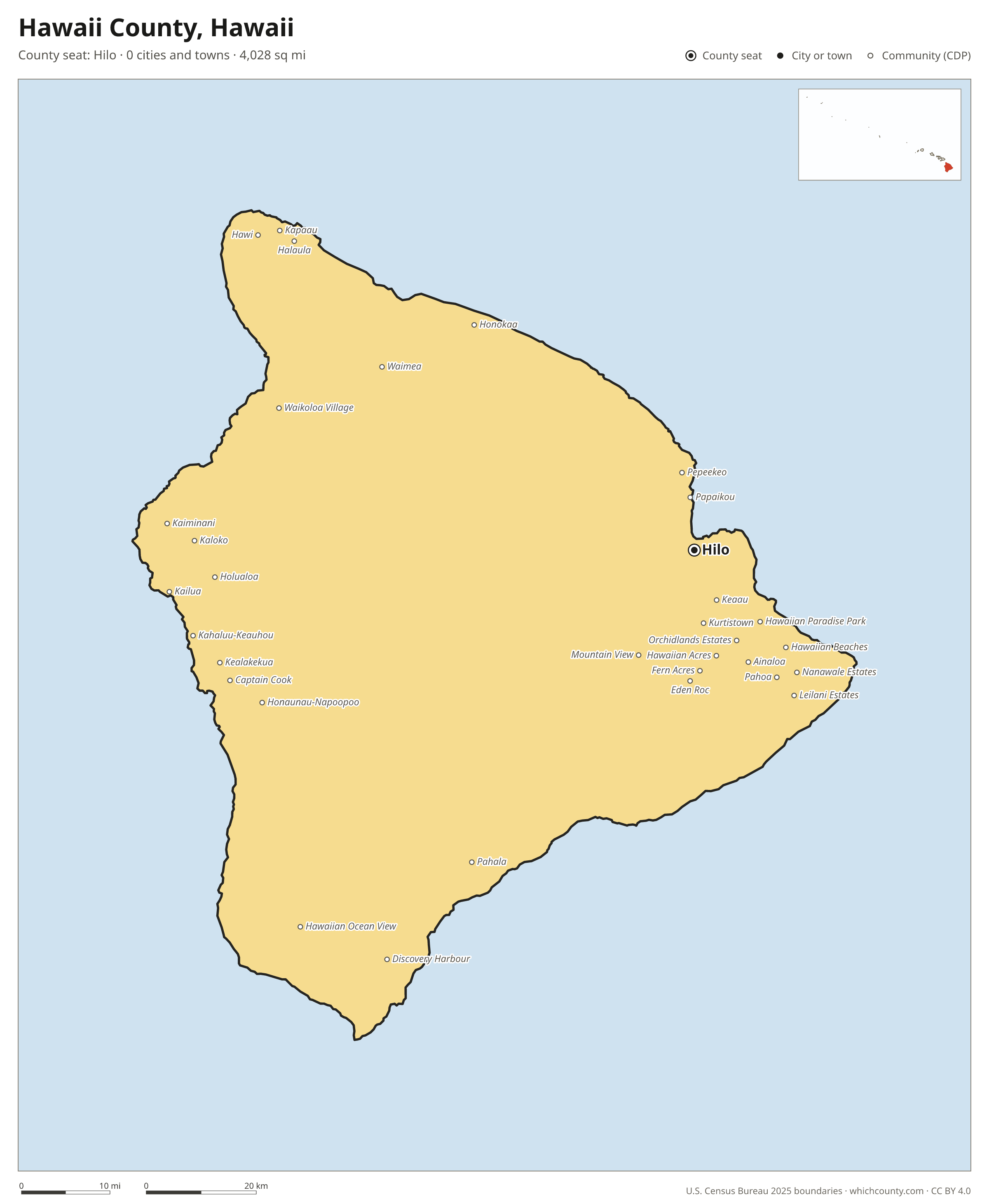
Hawaii County facts
- County seat
- Hilo
- Population (2025 estimate)
- 210,043 +4.7% since 2020
- Land area
- 4,028 sq mi 1st largest of 5
- Water area
- 1,058 sq mi
- Population density
- 52 per sq mi
- Established
- 1905
- Named after
- Hawaii largest of the Hawaiian islands
- Largest city
- Hilo 50,404
- Median household income
- $78,639
- Cities and towns
- 0 plus 54 CDPs
- ZIP codes
- 28
- Time zone
- Hawaii-Aleutian
- FIPS code
- 15001
Unincorporated communities (CDPs)
Census-designated places are communities without their own city government; the county provides their services.
| Community | Population | Also in |
|---|---|---|
| Hilo | 50,404 | |
| Kailua | 21,818 | |
| Hawaiian Paradise Park | 13,203 | |
| Kaiminani | 11,465 | |
| Waimea | 9,286 | |
| Waikoloa Village | 7,543 | |
| Kahaluu-Keauhou | 5,150 | |
| Hawaiian Ocean View | 4,431 | |
| Ainaloa | 4,094 | |
| Hawaiian Beaches | 3,947 | |
| Hawaiian Acres | 3,872 | |
| Mountain View | 3,756 | |
| Holualoa | 3,434 | |
| Captain Cook | 3,419 | |
| Kurtistown | 3,151 | |
| Orchidlands Estates | 3,027 | |
| Honaunau-Napoopoo | 2,629 | |
| Kapaau | 2,224 | |
| Hawi | 2,070 | |
| Pepeekeo | 2,056 | |
| Honokaa | 1,963 | |
| Kealakekua | 1,919 | |
| Pahala | 1,768 | |
| Nanawale Estates | 1,692 | |
| Leilani Estates | 1,490 | |
| Fern Acres | 1,480 | |
| Keaau | 1,436 | |
| Kaloko | 1,432 | |
| Pahoa | 1,361 | |
| Papaikou | 1,332 | |
| Eden Roc | 1,166 | |
| Fern Forest | 1,088 | |
| Discovery Harbour | 1,079 | |
| Honalo | 1,071 | |
| Halaula | 1,033 | |
| Wainaku | 967 | |
| Laupahoehoe | 916 | |
| Mauna Loa Estates | 901 | |
| Naalehu | 872 | |
| Royal Hawaiian Estates | 852 | |
| Volcano Golf Course | 807 | |
| Volcano | 746 | |
| Waikoloa Beach Resort | 656 | |
| Paauilo | 610 | |
| Paukaa | 450 | |
| Seaview | 443 | |
| Honomu | 376 | |
| Black Sands | 354 | |
| Kukuihaele | 310 | |
| Puako | 259 | |
| Tiki Gardens | 245 | |
| Kamaili | 221 | |
| Waiohinu | 152 | |
| Kalapana | 76 |
ZIP codes in Hawaii County
28 ZIP codes reach into Hawaii County. ZIP codes ignore county lines, so some also cover a neighboring county.
- 96704
- 96710
- 96719
- 96720
- 96725
- 96726
- 96727
- 96728
- 96737
- 96738
- 96740
- 96743
- 96749
- 96750
- 96755
- 96760
- 96764
- 96771
- 96772
- 96773
- 96774
- 96776
- 96777
- 96778
- 96780
- 96781
- 96783
- 96785
Population of Hawaii County, 2020–2025
Hawaii County grew by 9,411 people (+4.7%) between April 2020 and July 2025: 112 more births than deaths and a net gain of 9,345 people from migration.
| Year (July 1) | Population |
|---|---|
| 2020 | 200,744 |
| 2021 | 203,941 |
| 2022 | 206,031 |
| 2023 | 207,476 |
| 2024 | 209,050 |
| 2025 | 210,043 |
Printable Hawaii County map
The PDF is a vector file with real text: it prints sharp on Letter paper and you can search it for a town. The PNG is 2400 pixels wide for slides and documents. Both are free to use with a credit to WhichCounty.
- PDF (Letter) (150 KB)
- PNG (2400 px) (105 KB)
Paste this code to embed the map on your site:
Cite this map
- APA
- WhichCounty. (2026, October 4). Hawaii County, Hawaii Map [Map]. https://whichcounty.com/hawaii/hawaii-county/
- MLA
- “Hawaii County, Hawaii Map.” WhichCounty, 4 Oct. 2026, whichcounty.com/hawaii/hawaii-county/.
- Chicago
- WhichCounty. “Hawaii County, Hawaii Map.” Last modified October 4, 2026. https://whichcounty.com/hawaii/hawaii-county/.
Sources
- Boundaries: U.S. Census Bureau, 2025 Cartographic Boundary Files (1:500,000).
- Population: Census Bureau county and city estimates, Vintage 2025. CDP populations: American Community Survey 2020–2024.
- Places and ZIP codes: Census Bureau 2026 Gazetteer and 2020 ZIP Code Tabulation Area relationship files.
- County seat, founding year and name origin: Wikidata (CC0), checked against state sources.
Back to the Hawaii county map with all 5 counties. Found an error? Tell us.