Honolulu County, Hawaii
County seat: Honolulu · Population 988,703 (2025) · 601 sq mi
Honolulu County is the most populous of Hawaii's 5 counties, with 988,703 people (2025 estimate). Its county seat is Honolulu, which is also the state capital. The map shows its boundary.

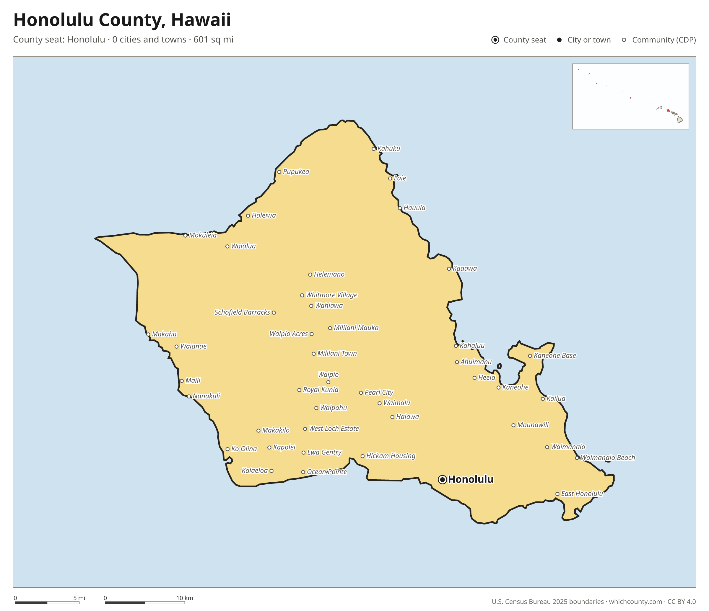
Honolulu County facts
- County seat
- Honolulu
- Population (2025 estimate)
- 988,703 −2.7% since 2020
- Land area
- 601 sq mi 4th largest of 5
- Water area
- 1,565 sq mi
- Population density
- 1,646 per sq mi
- Established
- 1907
- Named after
- Honolulu capital city of the U.S. state of Hawaii and seat of Honolulu County
- Largest city
- Honolulu 345,482
- Median household income
- $106,195
- Cities and towns
- 0 plus 55 CDPs
- ZIP codes
- 38
- Time zone
- Hawaii-Aleutian
- FIPS code
- 15003
Unincorporated communities (CDPs)
Census-designated places are communities without their own city government; the county provides their services.
| Community | Population | Also in |
|---|---|---|
| Honolulu | 345,482 | |
| East Honolulu | 51,360 | |
| Pearl City | 44,547 | |
| Waipahu | 40,482 | |
| Kailua | 39,640 | |
| Kaneohe | 37,355 | |
| Mililani Town | 27,668 | |
| Ewa Gentry | 26,563 | |
| Kapolei | 22,232 | |
| Mililani Mauka | 21,278 | |
| Makakilo | 20,735 | |
| Wahiawa | 17,996 | |
| Ocean Pointe | 17,085 | |
| Schofield Barracks | 16,270 | |
| Halawa | 14,385 | |
| Ewa Beach | 14,376 | |
| Royal Kunia | 13,555 | |
| Waimalu | 13,061 | |
| Waianae | 12,918 | |
| Nanakuli | 12,383 | |
| Maili | 11,570 | |
| Kaneohe Base | 10,919 | |
| Waipio | 10,870 | |
| Makaha | 10,066 | |
| Hickam Housing | 9,425 | |
| Aiea | 9,087 | |
| Ahuimanu | 8,452 | |
| East Kapolei | 7,551 | |
| Waikele | 7,528 | |
| Ewa Villages | 7,415 | |
| Waimanalo | 6,054 | |
| Laie | 5,699 | |
| Kahaluu | 5,619 | |
| West Loch Estate | 5,544 | |
| Waipio Acres | 5,332 | |
| Iroquois Point | 5,158 | |
| Heeia | 5,144 | |
| Haleiwa | 4,948 | |
| Pupukea | 4,679 | |
| Waimanalo Beach | 4,505 | |
| Whitmore Village | 4,105 | |
| Hauula | 3,548 | |
| Kalaeloa | 3,342 | |
| Waialua | 3,050 | |
| Helemano | 2,691 | |
| Kahuku | 2,375 | |
| Wheeler AFB | 2,097 | |
| Maunawili | 2,024 | |
| Ko Olina | 1,670 | |
| Mokuleia | 1,655 | |
| Kaaawa | 1,328 | |
| Punaluu | 950 | |
| Waiahole-Waikane | 829 | |
| Kawela Bay | 376 | |
| Makaha Valley | 163 |
ZIP codes in Honolulu County
38 ZIP codes reach into Honolulu County. ZIP codes ignore county lines, so some also cover a neighboring county.
- 96701
- 96706
- 96707
- 96712
- 96717
- 96730
- 96731
- 96734
- 96744
- 96759
- 96762
- 96782
- 96786
- 96789
- 96791
- 96792
- 96795
- 96797
- 96813
- 96814
- 96815
- 96816
- 96817
- 96818
- 96819
- 96820
- 96821
- 96822
- 96825
- 96826
- 96848
- 96850
- 96853
- 96857
- 96858
- 96859
- 96860
- 96863
Population of Honolulu County, 2020–2025
Honolulu County shrank by 27,801 people (−2.7%) between April 2020 and July 2025: 11,083 more births than deaths and a net loss of 38,460 people from migration.
| Year (July 1) | Population |
|---|---|
| 2020 | 1,012,334 |
| 2021 | 1,004,238 |
| 2022 | 993,798 |
| 2023 | 989,698 |
| 2024 | 990,142 |
| 2025 | 988,703 |
Printable Honolulu County map
The PDF is a vector file with real text: it prints sharp on Letter paper and you can search it for a town. The PNG is 2400 pixels wide for slides and documents. Both are free to use with a credit to WhichCounty.
- PDF (Letter) (154 KB)
- PNG (2400 px) (105 KB)
Paste this code to embed the map on your site:
Cite this map
- APA
- WhichCounty. (2026, October 4). Honolulu County, Hawaii Map [Map]. https://whichcounty.com/hawaii/honolulu-county/
- MLA
- “Honolulu County, Hawaii Map.” WhichCounty, 4 Oct. 2026, whichcounty.com/hawaii/honolulu-county/.
- Chicago
- WhichCounty. “Honolulu County, Hawaii Map.” Last modified October 4, 2026. https://whichcounty.com/hawaii/honolulu-county/.
Sources
- Boundaries: U.S. Census Bureau, 2025 Cartographic Boundary Files (1:500,000).
- Population: Census Bureau county and city estimates, Vintage 2025. CDP populations: American Community Survey 2020–2024.
- Places and ZIP codes: Census Bureau 2026 Gazetteer and 2020 ZIP Code Tabulation Area relationship files.
- County seat, founding year and name origin: Wikidata (CC0), checked against state sources.
Back to the Hawaii county map with all 5 counties. Found an error? Tell us.