Crow Wing County, Minnesota
County seat: Brainerd · Population 69,132 (2025) · 999 sq mi
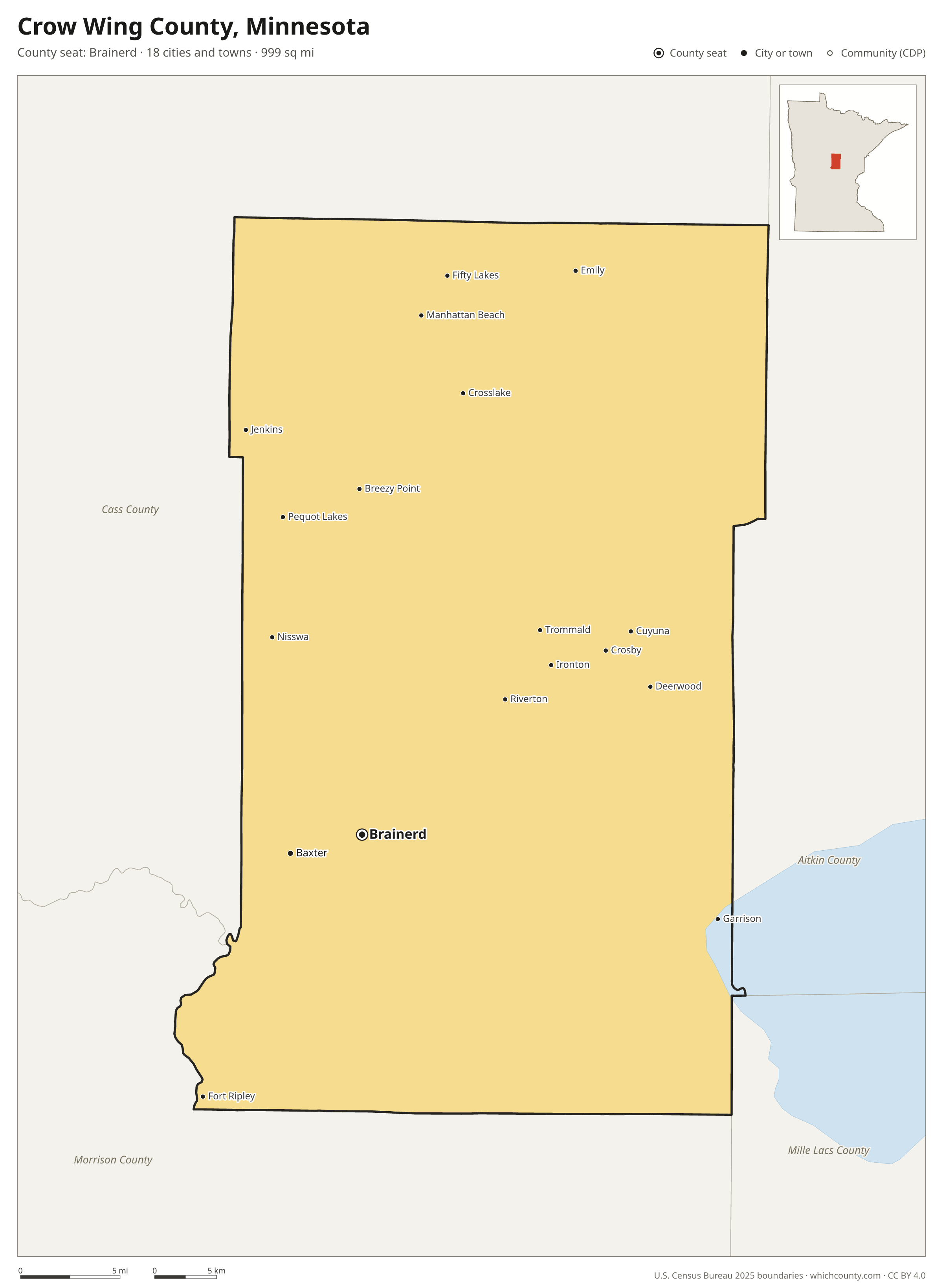
Crow Wing County is the 15th most populous of Minnesota's 87 counties, with 69,132 people (2025 estimate). Its county seat is Brainerd. The map shows its 18 cities and towns and the 4 neighboring counties.

Crow Wing County facts
- County seat
- Brainerd
- Population (2025 estimate)
- 69,132 +4.6% since 2020
- Land area
- 999 sq mi 21st largest of 87
- Water area
- 158 sq mi
- Population density
- 69 per sq mi
- Established
- 1857
- Named after
- Crow Wing River river in Minnesota, United States
- Largest city
- Brainerd 14,428
- Median household income
- $72,589
- Cities and towns
- 18 plus 1 CDPs
- ZIP codes
- 18
- Time zone
- Central
- FIPS code
- 27035
Cities and towns in Crow Wing County
Crow Wing County has 18 incorporated cities, towns and villages. Populations count the people living inside Crow Wing County; cities that cross a county line also list the other counties.
| Name | Type | Population 2025 | Also in |
|---|---|---|---|
| Brainerd (county seat) | City | 14,428 | |
| Baxter | City | 9,217 | |
| Breezy Point | City | 2,771 | |
| Pequot Lakes | City | 2,483 | |
| Crosslake | City | 2,412 | |
| Crosby | City | 2,330 | |
| Nisswa | City | 2,217 | |
| Emily | City | 870 | |
| Deerwood | City | 572 | |
| Ironton | City | 560 | |
| Jenkins | City | 515 | |
| Fifty Lakes | City | 462 | |
| Cuyuna | City | 340 | |
| Garrison | City | 201 | |
| Trommald | City | 113 | |
| Riverton | City | 111 | |
| Fort Ripley | City | 83 | |
| Manhattan Beach | City | 64 |
Unincorporated communities (CDPs)
Census-designated places are communities without their own city government; the county provides their services.
| Community | Population | Also in |
|---|---|---|
| Merrifield | 121 |
ZIP codes in Crow Wing County
18 ZIP codes reach into Crow Wing County. ZIP codes ignore county lines, so some also cover a neighboring county.
- 56338 also Morrison County
- 56364 also Morrison County
- 56401 also Cass County
- 56425
- 56431 also Aitkin County
- 56435 also Cass County
- 56441
- 56442
- 56444
- 56447
- 56448 also Cass County
- 56449 also Morrison County
- 56450 also Mille Lacs County
- 56455
- 56465
- 56468 also Cass County
- 56472 also Cass County
- 56474 also Cass County
Population of Crow Wing County, 2020–2025
Crow Wing County grew by 3,011 people (+4.6%) between April 2020 and July 2025: 686 more deaths than births and a net gain of 3,732 people from migration.
| Year (July 1) | Population |
|---|---|
| 2020 | 66,284 |
| 2021 | 67,380 |
| 2022 | 67,877 |
| 2023 | 68,339 |
| 2024 | 68,667 |
| 2025 | 69,132 |
Neighboring counties
- Cass County north · 31,430 people
- Aitkin County east · 16,252 people
- Morrison County south · 34,620 people
- Mille Lacs County southeast · 27,753 people
Printable Crow Wing County map
The PDF is a vector file with real text: it prints sharp on Letter paper and you can search it for a town. The PNG is 2400 pixels wide for slides and documents. Both are free to use with a credit to WhichCounty.
- PDF (Letter) (116 KB)
- PNG (2400 px) (88 KB)
Paste this code to embed the map on your site:
Cite this map
- APA
- WhichCounty. (2026, October 4). Crow Wing County, Minnesota Map [Map]. https://whichcounty.com/minnesota/crow-wing-county/
- MLA
- “Crow Wing County, Minnesota Map.” WhichCounty, 4 Oct. 2026, whichcounty.com/minnesota/crow-wing-county/.
- Chicago
- WhichCounty. “Crow Wing County, Minnesota Map.” Last modified October 4, 2026. https://whichcounty.com/minnesota/crow-wing-county/.
Sources
- Boundaries: U.S. Census Bureau, 2025 Cartographic Boundary Files (1:500,000).
- Population: Census Bureau county and city estimates, Vintage 2025. CDP populations: American Community Survey 2020–2024.
- Places and ZIP codes: Census Bureau 2026 Gazetteer and 2020 ZIP Code Tabulation Area relationship files.
- County seat, founding year and name origin: Wikidata (CC0), checked against state sources.
Back to the Minnesota county map with all 87 counties. Found an error? Tell us.