St. Louis County, Missouri
County seat: Clayton · Population 990,911 (2025) · 509 sq mi
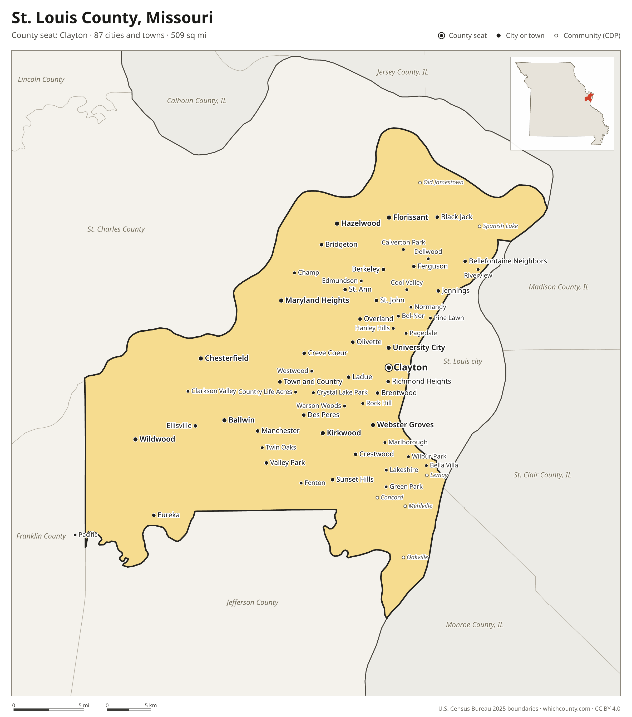
St. Louis County is the most populous of Missouri's 115 counties, with 990,911 people (2025 estimate). Its county seat is Clayton. It is part of the East-West Gateway Council of Governments region, one of the 19 Regional Planning Commissions and Councils of Governments of Missouri. The map shows its 87 cities and towns and the 7 neighboring counties.

St. Louis County facts
- County seat
- Clayton
- Population (2025 estimate)
- 990,911 −1.4% since 2020
- Land area
- 509 sq mi 77th largest of 115
- Water area
- 15 sq mi
- Population density
- 1,949 per sq mi
- Established
- 1812
- Named after
- Louis IX of France King of France from 1226 to 1270 (1214–1270)
- Largest city
- Florissant 51,124
- Median household income
- $82,936
- Cities and towns
- 87 plus 11 CDPs
- ZIP codes
- 47
- Time zone
- Central
- FIPS code
- 29189
Cities and towns in St. Louis County
St. Louis County has 87 incorporated cities, towns and villages. Populations count the people living inside St. Louis County; cities that cross a county line also list the other counties.
| Name | Type | Population 2025 | Also in |
|---|---|---|---|
| Florissant | City | 51,124 | |
| Chesterfield | City | 49,309 | |
| Wildwood | City | 34,955 | |
| University City | City | 34,657 | |
| Ballwin | City | 30,901 | |
| Kirkwood | City | 29,331 | |
| Maryland Heights | City | 27,559 | |
| Hazelwood | City | 24,849 | |
| Webster Groves | City | 23,450 | |
| Creve Coeur | City | 18,480 | |
| Manchester | City | 18,069 | |
| Ferguson | City | 17,953 | |
| Clayton (county seat) | City | 17,807 | |
| Overland | City | 15,474 | |
| Eureka | City | 13,341 | Jefferson County |
| Jennings | City | 13,093 | |
| St. Ann | City | 12,617 | |
| Crestwood | City | 12,207 | |
| Town and Country | City | 11,619 | |
| Bridgeton | City | 11,277 | |
| Bellefontaine Neighbors | City | 10,368 | |
| Ellisville | City | 10,315 | |
| Des Peres | City | 9,102 | |
| Richmond Heights | City | 9,093 | |
| Sunset Hills | City | 9,075 | |
| Olivette | City | 8,937 | |
| Ladue | City | 8,934 | |
| Brentwood | City | 8,079 | |
| Maplewood | City | 8,033 | |
| Berkeley | City | 8,026 | |
| Valley Park | City | 6,767 | |
| Black Jack | City | 6,547 | |
| St. John | City | 6,441 | |
| Shrewsbury | City | 6,231 | |
| Glendale | City | 6,060 | |
| Dellwood | City | 4,825 | |
| Rock Hill | City | 4,668 | |
| Normandy | City | 4,380 | |
| Breckenridge Hills | City | 4,350 | |
| Fenton | City | 4,060 | |
| Woodson Terrace | City | 3,902 | |
| Frontenac | City | 3,790 | |
| Northwoods | City | 3,579 | |
| Pine Lawn | City | 2,682 | |
| Green Park | City | 2,670 | |
| Clarkson Valley | City | 2,540 | |
| Pagedale | City | 2,511 | |
| Riverview | Village | 2,330 | |
| Marlborough | Village | 2,185 | |
| Moline Acres | City | 2,093 | |
| Bel-Ridge | Village | 2,070 | |
| Warson Woods | City | 1,990 | |
| Hanley Hills | Village | 1,963 | |
| Vinita Park | City | 1,923 | |
| Wellston | City | 1,580 | |
| Lakeshire | City | 1,510 | |
| Winchester | City | 1,400 | |
| Oakland | City | 1,372 | |
| Bel-Nor | Village | 1,351 | |
| Velda City | City | 1,309 | |
| Charlack | City | 1,275 | |
| Hillsdale | Village | 1,180 | |
| Calverton Park | City | 1,134 | |
| Pacific | City | 1,063 | Franklin County |
| Cool Valley | City | 1,005 | |
| Country Club Hills | City | 998 | |
| Grantwood Village | Town | 925 | |
| Pasadena Hills | City | 881 | |
| Norwood Court | Town | 877 | |
| Velda Village Hills | City | 851 | |
| Edmundson | City | 842 | |
| Bella Villa | City | 723 | |
| Flordell Hills | City | 702 | |
| Greendale | City | 634 | |
| Twin Oaks | Village | 583 | |
| Sycamore Hills | Village | 546 | |
| Crystal Lake Park | City | 501 | |
| Beverly Hills | City | 456 | |
| Pasadena Park | Village | 426 | |
| Wilbur Park | Village | 425 | |
| Huntleigh | City | 352 | |
| Westwood | Village | 308 | |
| Uplands Park | Village | 305 | |
| Kinloch | City | 261 | |
| Bellerive Acres | City | 181 | |
| Country Life Acres | Village | 71 | |
| Champ | Village | 9 |
Unincorporated communities (CDPs)
Census-designated places are communities without their own city government; the county provides their services.
| Community | Population | Also in |
|---|---|---|
| Oakville | 35,333 | |
| Mehlville | 29,805 | |
| Old Jamestown | 20,651 | |
| Affton | 19,052 | |
| Concord | 18,368 | |
| Spanish Lake | 17,873 | |
| Lemay | 16,228 | |
| Sappington | 7,367 | |
| Glasgow Village | 5,504 | |
| Castle Point | 2,340 | |
| St. George | 1,458 |
ZIP codes in St. Louis County
47 ZIP codes reach into St. Louis County. ZIP codes ignore county lines, so some also cover a neighboring county.
- 63005 also Franklin County
- 63011
- 63017
- 63021
- 63025 also Jefferson County
- 63026 also Jefferson County
- 63031
- 63033
- 63034
- 63038
- 63040
- 63042
- 63043
- 63044
- 63045
- 63049 also Jefferson County
- 63069 also Franklin and Jefferson counties
- 63074
- 63088
- 63105 also St. Louis city
- 63114
- 63117 also St. Louis city
- 63119 also St. Louis city
- 63120 also St. Louis city
- 63121
- 63122
- 63123 also St. Louis city
- 63124
- 63125 also St. Louis city
- 63126
- 63127
- 63128
- 63129
- 63130 also St. Louis city
- 63131
- 63132
- 63133 also St. Louis city
- 63134
- 63135
- 63136 also St. Louis city
- 63137 also St. Louis city
- 63138 also St. Louis city
- 63140
- 63141
- 63143 also St. Louis city
- 63144
- 63146
Population of St. Louis County, 2020–2025
St. Louis County shrank by 13,637 people (−1.4%) between April 2020 and July 2025: 6,320 more deaths than births and a net loss of 7,914 people from migration.
| Year (July 1) | Population |
|---|---|
| 2020 | 1,003,365 |
| 2021 | 998,850 |
| 2022 | 991,719 |
| 2023 | 989,977 |
| 2024 | 991,666 |
| 2025 | 990,911 |
Neighboring counties
- St. Charles County northwest · 426,499 people
- Jefferson County south · 233,132 people
- St. Louis city east · 278,144 people
- Franklin County southwest · 108,090 people
- Monroe County, Illinois southeast · 34,840 people
- Madison County, Illinois northeast · 263,110 people
- St. Clair County, Illinois southeast · 250,708 people
Printable St. Louis County map
The PDF is a vector file with real text: it prints sharp on Letter paper and you can search it for a town. The PNG is 2400 pixels wide for slides and documents. Both are free to use with a credit to WhichCounty.
- PDF (Letter) (258 KB)
- PNG (2400 px) (189 KB)
Paste this code to embed the map on your site:
Cite this map
- APA
- WhichCounty. (2026, October 4). St. Louis County, Missouri Map [Map]. https://whichcounty.com/missouri/st-louis-county/
- MLA
- “St. Louis County, Missouri Map.” WhichCounty, 4 Oct. 2026, whichcounty.com/missouri/st-louis-county/.
- Chicago
- WhichCounty. “St. Louis County, Missouri Map.” Last modified October 4, 2026. https://whichcounty.com/missouri/st-louis-county/.
Sources
- Boundaries: U.S. Census Bureau, 2025 Cartographic Boundary Files (1:500,000).
- Population: Census Bureau county and city estimates, Vintage 2025. CDP populations: American Community Survey 2020–2024.
- Places and ZIP codes: Census Bureau 2026 Gazetteer and 2020 ZIP Code Tabulation Area relationship files.
- County seat, founding year and name origin: Wikidata (CC0), checked against state sources.
Back to the Missouri county map with all 115 counties. Found an error? Tell us.