Cumberland County, New Jersey
County seat: Bridgeton · Population 157,148 (2025) · 483 sq mi
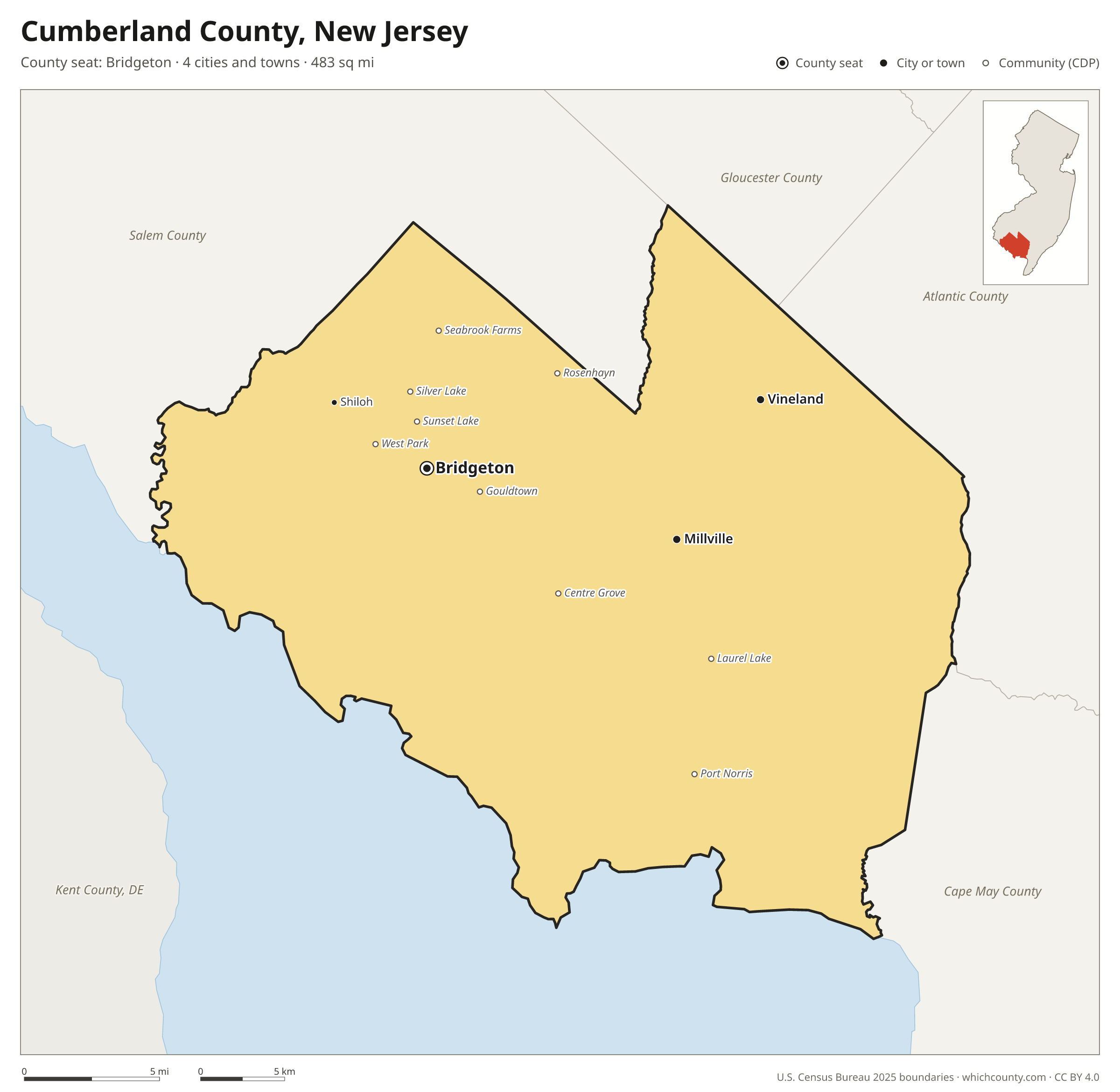
Cumberland County is the 16th most populous of New Jersey's 21 counties, with 157,148 people (2025 estimate). Its county seat is Bridgeton. The map shows its 4 cities and towns and the 5 neighboring counties.

Cumberland County facts
- County seat
- Bridgeton
- Population (2025 estimate)
- 157,148 +2% since 2020
- Land area
- 483 sq mi 5th largest of 21
- Water area
- 195 sq mi
- Population density
- 325 per sq mi
- Established
- 1748
- Same name
- One of 8 Cumberland Counties in the US
- Named after
- Prince William, Duke of Cumberland British Army general; (1721-1765)
- Largest city
- Vineland 62,703
- Median household income
- $67,436
- Cities and towns
- 4 plus 36 CDPs
- ZIP codes
- 22
- Time zone
- Eastern
- FIPS code
- 34011
Cities and towns in Cumberland County
Cumberland County has 4 incorporated cities, towns and villages. Populations count the people living inside Cumberland County; cities that cross a county line also list the other counties.
| Name | Type | Population 2025 | Also in |
|---|---|---|---|
| Vineland | City | 62,703 | |
| Bridgeton (county seat) | City | 28,307 | |
| Millville | City | 28,098 | |
| Shiloh | Borough | 456 |
Unincorporated communities (CDPs)
Census-designated places are communities without their own city government; the county provides their services.
| Community | Population | Also in |
|---|---|---|
| Laurel Lake | 2,641 | |
| Silver Lake | 2,011 | |
| Port Norris | 1,612 | |
| Gouldtown | 1,546 | |
| Seabrook Farms | 1,448 | |
| Centre Grove | 1,339 | |
| Rosenhayn | 1,308 | |
| Sunset Lake | 1,194 | |
| West Park | 1,079 | |
| Fairton | 930 | |
| Carlls Corner | 868 | |
| Cedarville | 661 | |
| Dividing Creek | 652 | |
| Newport | 533 | |
| Laurel Heights | 474 | |
| Leesburg | 431 | |
| Mauricetown | 365 | |
| Milmay | 343 | Atlantic County |
| Deerfield Street | 322 | |
| Port Elizabeth | 261 | |
| Delmont | 223 | |
| Lakeside-Beebe Run | 222 | |
| Roadstown | 201 | |
| Heislerville | 198 | |
| Greenwich | 175 | |
| Dorchester | 137 | |
| Othello | 132 | |
| Fortescue | 120 | |
| Arrowhead Lake | 101 | |
| Dutch Neck | 96 | |
| Cumberland-Hesstown | 90 | |
| Seeley | 85 | |
| Marlboro | 76 | |
| Sheppards Mill | 61 | |
| Gandys Beach | 43 | |
| Money Island | 25 |
ZIP codes in Cumberland County
22 ZIP codes reach into Cumberland County. ZIP codes ignore county lines, so some also cover a neighboring county.
- 08270 also Cape May and Atlantic counties
- 08302 also Salem County
- 08311
- 08314
- 08316
- 08318 also Salem County
- 08320
- 08321
- 08323
- 08324
- 08327
- 08329
- 08332
- 08340 also Atlantic County
- 08344 also Gloucester, Atlantic and Salem counties
- 08345
- 08348
- 08349
- 08352
- 08353
- 08360 also Atlantic and Gloucester counties
- 08361
Population of Cumberland County, 2020–2025
Cumberland County grew by 3,003 people (+2%) between April 2020 and July 2025: 98 more births than deaths and a net gain of 2,960 people from migration.
| Year (July 1) | Population |
|---|---|
| 2020 | 153,733 |
| 2021 | 152,124 |
| 2022 | 152,025 |
| 2023 | 154,497 |
| 2024 | 156,407 |
| 2025 | 157,148 |
Neighboring counties
- Salem County northwest · 66,280 people
- Cape May County southeast · 93,390 people
- Kent County, Delaware southwest · 194,786 people
- Atlantic County east · 278,657 people
- Gloucester County north · 312,638 people
Printable Cumberland County map
The PDF is a vector file with real text: it prints sharp on Letter paper and you can search it for a town. The PNG is 2400 pixels wide for slides and documents. Both are free to use with a credit to WhichCounty.
- PDF (Letter) (105 KB)
- PNG (2400 px) (99 KB)
Paste this code to embed the map on your site:
Sources
- Boundaries: U.S. Census Bureau, 2025 Cartographic Boundary Files (1:500,000).
- Population: Census Bureau county and city estimates, Vintage 2025. CDP populations: American Community Survey 2020–2024.
- Places and ZIP codes: Census Bureau 2026 Gazetteer and 2020 ZIP Code Tabulation Area relationship files.
- County seat, founding year and name origin: Wikidata (CC0), checked against state sources.
Back to the New Jersey county map with all 21 counties. Found an error? Tell us.