Hamilton County, Ohio
County seat: Cincinnati · Population 838,418 (2025) · 406 sq mi
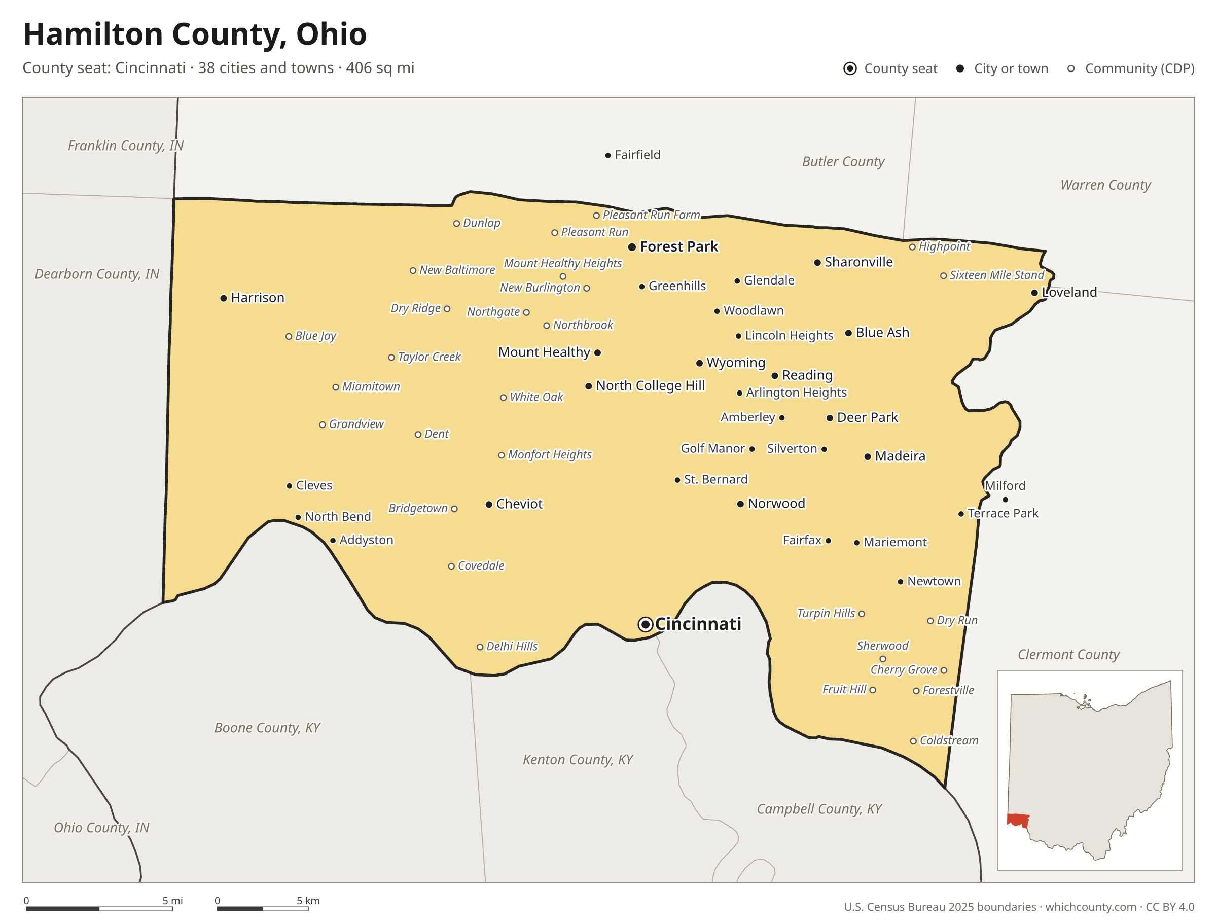
Hamilton County is the 3rd most populous of Ohio's 88 counties, with 838,418 people (2025 estimate). Its county seat is Cincinnati. The map shows its 38 cities and towns and the 8 neighboring counties.

Hamilton County facts
- County seat
- Cincinnati
- Population (2025 estimate)
- 838,418 +0.9% since 2020
- Land area
- 406 sq mi 73rd largest of 88
- Water area
- 7 sq mi
- Population density
- 2,068 per sq mi
- Established
- 1790
- Named after
- Alexander Hamilton American Founding Father and statesman (1755/1757–1804)
- Largest city
- Cincinnati 314,367
- Median household income
- $72,470
- Cities and towns
- 38 plus 51 CDPs
- ZIP codes
- 58
- Time zone
- Eastern
- FIPS code
- 39061
Cities and towns in Hamilton County
Hamilton County has 38 incorporated cities, towns and villages. Populations count the people living inside Hamilton County; cities that cross a county line also list the other counties.
| Name | Type | Population 2025 | Also in |
|---|---|---|---|
| Cincinnati (county seat) | City | 314,367 | |
| Forest Park | City | 20,041 | |
| Norwood | City | 19,658 | |
| Harrison | City | 13,795 | |
| Blue Ash | City | 13,707 | |
| Sharonville | City | 11,440 | Butler County |
| Springdale | City | 11,134 | |
| Montgomery | City | 10,922 | |
| Reading | City | 10,491 | |
| Loveland | City | 9,714 | Clermont and Warren counties |
| Madeira | City | 9,637 | |
| North College Hill | City | 9,544 | |
| Wyoming | City | 8,807 | |
| Cheviot | City | 8,623 | |
| Mount Healthy | City | 6,917 | |
| The Village of Indian Hill | City | 6,114 | |
| Deer Park | City | 5,557 | |
| Silverton | Village | 4,887 | |
| St. Bernard | Village | 3,983 | |
| Woodlawn | Village | 3,928 | |
| Amberley | Village | 3,841 | |
| Golf Manor | Village | 3,810 | |
| Greenhills | Village | 3,721 | |
| Lockland | Village | 3,499 | |
| Mariemont | Village | 3,499 | |
| Cleves | Village | 3,391 | |
| Lincoln Heights | Village | 3,151 | |
| Newtown | Village | 2,684 | |
| Evendale | Village | 2,657 | |
| Terrace Park | Village | 2,357 | |
| Glendale | Village | 2,285 | |
| Elmwood Place | Village | 2,083 | |
| Fairfax | Village | 1,764 | |
| Addyston | Village | 911 | |
| North Bend | Village | 841 | |
| Arlington Heights | Village | 823 | |
| Milford | City | 24 | Clermont County |
| Fairfield | City | 0 | Butler County |
Unincorporated communities (CDPs)
Census-designated places are communities without their own city government; the county provides their services.
| Community | Population | Also in |
|---|---|---|
| White Oak | 19,216 | |
| Bridgetown | 13,464 | |
| Finneytown | 12,506 | |
| Monfort Heights | 12,441 | |
| Dent | 11,973 | |
| Mack | 11,516 | |
| Forestville | 10,831 | |
| Northbrook | 10,742 | |
| Kenwood | 8,326 | |
| Groesbeck | 7,824 | |
| Dry Run | 7,687 | |
| Northgate | 6,723 | |
| Covedale | 6,500 | |
| Pleasant Run | 5,629 | |
| New Burlington | 5,426 | |
| Miami Heights | 5,269 | |
| Delhi Hills | 5,241 | |
| Turpin Hills | 4,875 | |
| Pleasant Run Farm | 4,524 | |
| Taylor Creek | 4,253 | |
| Fruit Hill | 4,200 | |
| Cherry Grove | 4,176 | |
| Delshire | 3,907 | |
| Sherwood | 3,808 | |
| Sixteen Mile Stand | 3,666 | |
| Salem Heights | 3,602 | |
| Dillonvale | 3,514 | |
| Mount Healthy Heights | 3,263 | |
| Dry Ridge | 2,554 | |
| Blue Jay | 1,797 | |
| New Baltimore | 1,585 | |
| Coldstream | 1,540 | |
| Rossmoyne | 1,504 | |
| Grandview | 1,382 | |
| Miamitown | 1,169 | |
| Highpoint | 1,132 | |
| Pleasant Hills | 1,097 | |
| Dunlap | 1,085 | |
| Skyline Acres | 1,016 | |
| Brecon | 860 | |
| Madison Place | 815 | |
| Concorde Hills | 762 | |
| Shawnee | 739 | |
| Remington | 604 | |
| Hooven | 403 | |
| Ridgewood | 380 | |
| Loveland Park | 359 | Warren County |
| Elizabethtown | 347 | |
| New Haven | 340 | |
| Camp Dennison | 265 | |
| Plainville | 100 |
ZIP codes in Hamilton County
58 ZIP codes reach into Hamilton County. ZIP codes ignore county lines, so some also cover a neighboring county.
- 45001
- 45002
- 45013 also Butler County
- 45030
- 45033
- 45041
- 45051
- 45052
- 45069 also Butler County
- 45111
- 45140 also Clermont and Warren counties
- 45150 also Clermont County
- 45174
- 45202
- 45203
- 45204
- 45205
- 45206
- 45207
- 45208
- 45209
- 45211
- 45212
- 45213
- 45214
- 45215
- 45216
- 45217
- 45218
- 45219
- 45220
- 45223
- 45224
- 45225
- 45226
- 45227
- 45229
- 45230
- 45231
- 45232
- 45233
- 45236
- 45237
- 45238
- 45239
- 45240
- 45241 also Butler and Warren counties
- 45242
- 45243
- 45244 also Clermont County
- 45246 also Butler County
- 45247
- 45248
- 45249 also Warren County
- 45251
- 45252
- 45255 also Clermont County
- 45267
Population of Hamilton County, 2020–2025
Hamilton County grew by 7,787 people (+0.9%) between April 2020 and July 2025: 8,601 more births than deaths and a net loss of 857 people from migration.
| Year (July 1) | Population |
|---|---|
| 2020 | 830,412 |
| 2021 | 827,182 |
| 2022 | 826,532 |
| 2023 | 831,699 |
| 2024 | 837,859 |
| 2025 | 838,418 |
Neighboring counties
- Butler County north · 400,128 people
- Clermont County southeast · 216,977 people
- Campbell County, Kentucky southeast · 95,441 people
- Boone County, Kentucky southwest · 145,316 people
- Dearborn County, Indiana west · 51,609 people
- Kenton County, Kentucky south · 175,779 people
- Warren County northeast · 257,181 people
- Franklin County, Indiana northwest · 23,286 people
Printable Hamilton County map
The PDF is a vector file with real text: it prints sharp on Letter paper and you can search it for a town. The PNG is 2400 pixels wide for slides and documents. Both are free to use with a credit to WhichCounty.
- PDF (Letter) (245 KB)
- PNG (2400 px) (157 KB)
Paste this code to embed the map on your site:
Sources
- Boundaries: U.S. Census Bureau, 2025 Cartographic Boundary Files (1:500,000).
- Population: Census Bureau county and city estimates, Vintage 2025. CDP populations: American Community Survey 2020–2024.
- Places and ZIP codes: Census Bureau 2026 Gazetteer and 2020 ZIP Code Tabulation Area relationship files.
- County seat, founding year and name origin: Wikidata (CC0), checked against state sources.
Back to the Ohio county map with all 88 counties. Found an error? Tell us.