Accomack County, Virginia
County seat: Accomac · Population 33,859 (2025) · 449 sq mi
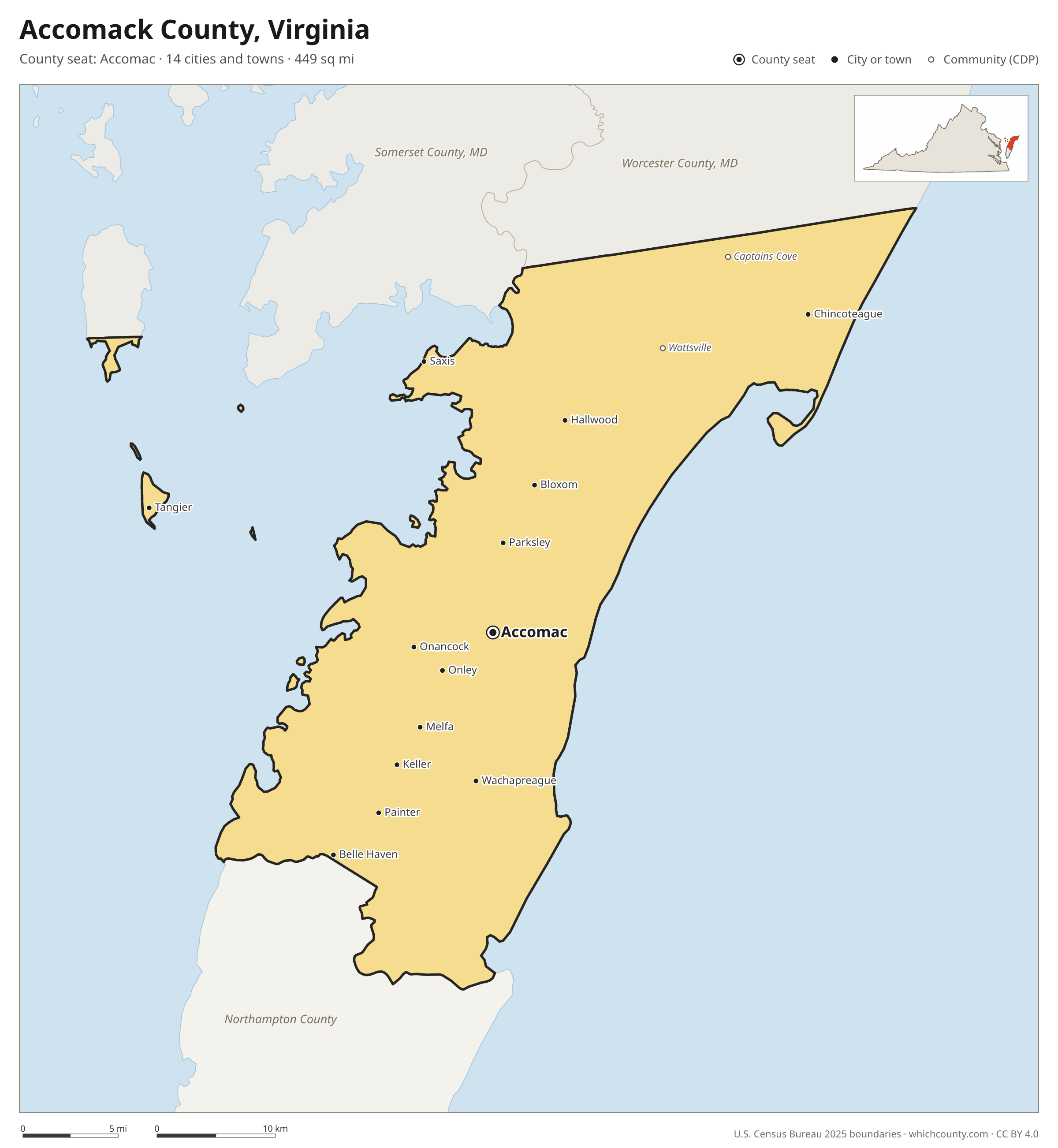
Accomack County is the 52nd most populous of Virginia's 133 counties, with 33,859 people (2025 estimate). Its county seat is Accomac. It is part of the Accomack-Northampton Planning District Commission (PD 22) region, one of the 21 Planning District Commissions of Virginia. The map shows its 14 cities and towns and the 7 neighboring counties.

Accomack County facts
- County seat
- Accomac
- Population (2025 estimate)
- 33,859 +1.3% since 2020
- Land area
- 449 sq mi 36th largest of 133
- Water area
- 861 sq mi
- Population density
- 75 per sq mi
- Established
- 1663
- Named after
- Accomac Shire former county in Virginia of which the town was the county seat
- Largest city
- Chincoteague 3,309
- Median household income
- $58,993
- Cities and towns
- 14 plus 35 CDPs
- ZIP codes
- 33
- Time zone
- Eastern
- FIPS code
- 51001
Cities and towns in Accomack County
Accomack County has 14 incorporated cities, towns and villages. Populations count the people living inside Accomack County; cities that cross a county line also list the other counties.
| Name | Type | Population 2025 | Also in |
|---|---|---|---|
| Chincoteague | Town | 3,309 | |
| Onancock | Town | 1,177 | |
| Parksley | Town | 823 | |
| Onley | Town | 541 | |
| Accomac (county seat) | Town | 522 | |
| Belle Haven | Town | 472 | Northampton County |
| Tangier | Town | 442 | |
| Melfa | Town | 405 | |
| Bloxom | Town | 386 | |
| Painter | Town | 278 | |
| Wachapreague | Town | 257 | |
| Hallwood | Town | 208 | |
| Saxis | Town | 169 | |
| Keller | Town | 145 |
Unincorporated communities (CDPs)
Census-designated places are communities without their own city government; the county provides their services.
| Community | Population | Also in |
|---|---|---|
| Captains Cove | 1,542 | |
| Wattsville | 1,439 | |
| Pastoria | 863 | |
| Nelsonia | 608 | |
| Gargatha | 564 | |
| Horntown | 466 | |
| Metompkin | 447 | |
| New Church | 443 | |
| Chase Crossing | 372 | |
| Atlantic | 342 | |
| Greenbush | 337 | |
| Modest Town | 265 | |
| Schooner Bay | 223 | |
| Cats Bridge | 200 | |
| Quinby | 198 | |
| Pungoteague | 190 | |
| Mappsville | 186 | |
| Savage Town | 175 | |
| Makemie Park | 150 | |
| Bobtown | 141 | |
| Savageville | 124 | |
| Temperanceville | 115 | |
| Mappsburg | 103 | |
| Boston | 96 | |
| Deep Creek | 95 | |
| Locust Mount | 95 | |
| Harborton | 92 | |
| Greenbackville | 86 | |
| Oak Hall | 86 | |
| Southside Chesconessex | 84 | |
| Lee Mont | 79 | |
| Whitesville | 65 | |
| Sanford | 44 | |
| Tasley | 23 | |
| Bayside | 21 |
ZIP codes in Accomack County
33 ZIP codes reach into Accomack County. ZIP codes ignore county lines, so some also cover a neighboring county.
- 23301
- 23302
- 23303
- 23306
- 23308
- 23336
- 23337
- 23356
- 23357
- 23358
- 23359
- 23389
- 23395
- 23401
- 23407
- 23409
- 23410
- 23414
- 23415
- 23416
- 23417
- 23418
- 23420
- 23421
- 23422
- 23423
- 23426
- 23427
- 23440
- 23441
- 23442
- 23480
- 23488
Population of Accomack County, 2020–2025
Accomack County grew by 436 people (+1.3%) between April 2020 and July 2025: 789 more deaths than births and a net gain of 1,232 people from migration.
| Year (July 1) | Population |
|---|---|
| 2020 | 33,400 |
| 2021 | 33,435 |
| 2022 | 33,221 |
| 2023 | 33,510 |
| 2024 | 33,747 |
| 2025 | 33,859 |
Neighboring counties
- Somerset County, Maryland north · 24,973 people
- Northampton County south · 11,879 people
- Worcester County, Maryland northeast · 54,459 people
- Northumberland County west · 12,557 people
- Lancaster County west · 10,995 people
- Middlesex County west · 10,841 people
- Mathews County southwest · 8,529 people
Printable Accomack County map
The PDF is a vector file with real text: it prints sharp on Letter paper and you can search it for a town. The PNG is 2400 pixels wide for slides and documents. Both are free to use with a credit to WhichCounty.
- PDF (Letter) (132 KB)
- PNG (2400 px) (118 KB)
Paste this code to embed the map on your site:
Sources
- Boundaries: U.S. Census Bureau, 2025 Cartographic Boundary Files (1:500,000).
- Population: Census Bureau county and city estimates, Vintage 2025. CDP populations: American Community Survey 2020–2024.
- Places and ZIP codes: Census Bureau 2026 Gazetteer and 2020 ZIP Code Tabulation Area relationship files.
- County seat, founding year and name origin: Wikidata (CC0), checked against state sources.
Back to the Virginia county map with all 133 counties. Found an error? Tell us.