Nevada County, California
County seat: Nevada City · Population 101,911 (2025) · 958 sq mi
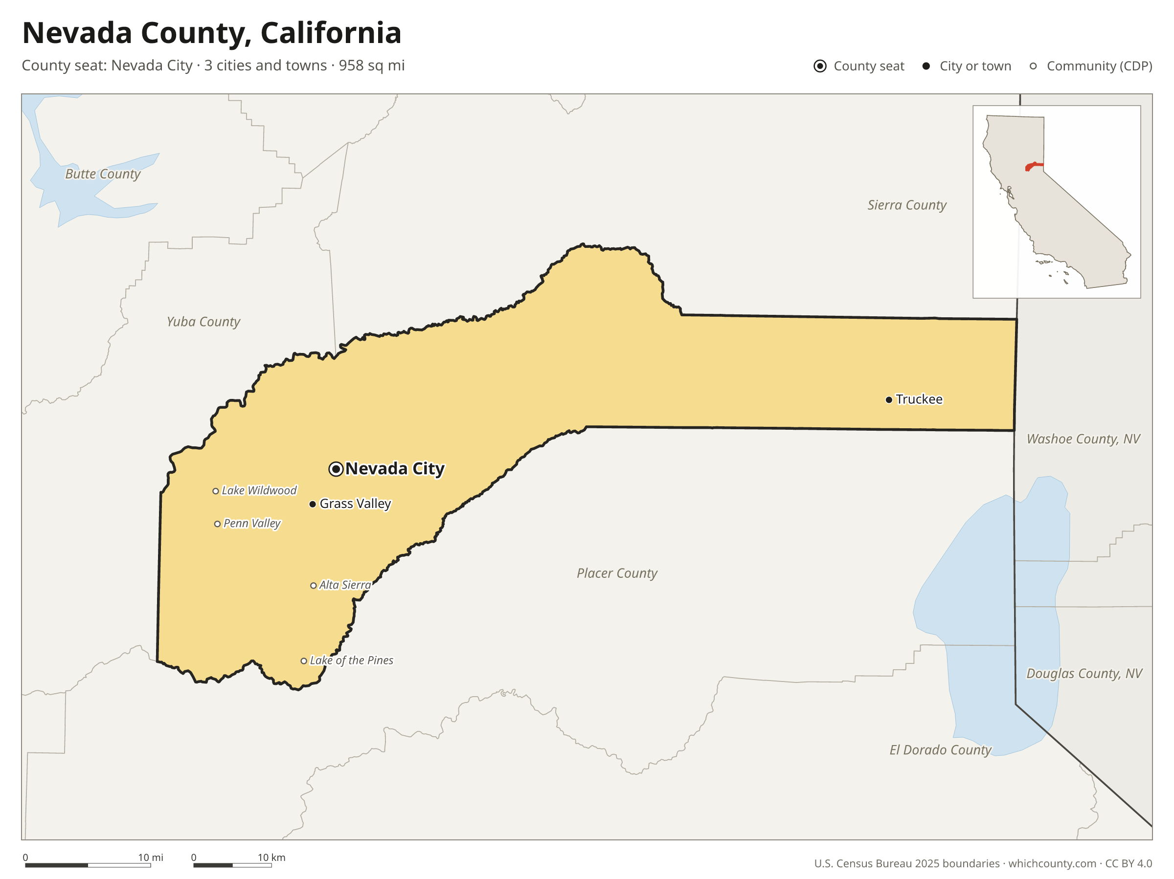
Nevada County is the 36th most populous of California's 58 counties, with 101,911 people (2025 estimate). Its county seat is Nevada City. The map shows its 3 cities and towns and the 4 neighboring counties.

Nevada County facts
- County seat
- Nevada City
- Population (2025 estimate)
- 101,911 −0.3% since 2020
- Land area
- 958 sq mi 44th largest of 58
- Water area
- 16 sq mi
- Population density
- 106 per sq mi
- Established
- 1851
- Named after
- Nevada City town and county seat of Nevada County, California, United States
- Largest city
- Truckee 17,278
- Median household income
- $89,882
- Cities and towns
- 3 plus 11 CDPs
- ZIP codes
- 12
- Time zone
- Pacific
- FIPS code
- 06057
Cities and towns in Nevada County
Nevada County has 3 incorporated cities, towns and villages. Populations count the people living inside Nevada County; cities that cross a county line also list the other counties.
| Name | Type | Population 2025 | Also in |
|---|---|---|---|
| Truckee | Town | 17,278 | |
| Grass Valley | City | 14,035 | |
| Nevada City (county seat) | City | 3,174 |
Unincorporated communities (CDPs)
Census-designated places are communities without their own city government; the county provides their services.
| Community | Population | Also in |
|---|---|---|
| Alta Sierra | 7,361 | |
| Lake of the Pines | 5,461 | |
| Lake Wildwood | 4,792 | |
| Penn Valley | 1,678 | |
| Rough and Ready | 736 | |
| North San Juan | 179 | |
| Soda Springs | 150 | |
| Washington | 129 | |
| Floriston | 26 | |
| Graniteville | 0 | |
| Kingvale | 0 | Placer County |
ZIP codes in Nevada County
12 ZIP codes reach into Nevada County. ZIP codes ignore county lines, so some also cover a neighboring county.
- 95602 also Placer County
- 95728 also Placer County
- 95945
- 95946
- 95949
- 95959
- 95960 also Sierra and Yuba counties
- 95975
- 95977 also Yuba County
- 95986
- 96111
- 96161 also Placer County
Population of Nevada County, 2020–2025
Nevada County shrank by 323 people (−0.3%) between April 2020 and July 2025: 1,996 more deaths than births and a net gain of 1,849 people from migration.
| Year (July 1) | Population |
|---|---|
| 2020 | 102,280 |
| 2021 | 103,496 |
| 2022 | 102,377 |
| 2023 | 102,060 |
| 2024 | 102,146 |
| 2025 | 101,911 |
Neighboring counties
- Placer County south · 442,081 people
- Sierra County northeast · 3,098 people
- Yuba County west · 88,691 people
- Washoe County, Nevada northeast · 509,386 people
Printable Nevada County map
The PDF is a vector file with real text: it prints sharp on Letter paper and you can search it for a town. The PNG is 2400 pixels wide for slides and documents. Both are free to use with a credit to WhichCounty.
- PDF (Letter) (136 KB)
- PNG (2400 px) (96 KB)
Paste this code to embed the map on your site:
Sources
- Boundaries: U.S. Census Bureau, 2025 Cartographic Boundary Files (1:500,000).
- Population: Census Bureau county and city estimates, Vintage 2025. CDP populations: American Community Survey 2020–2024.
- Places and ZIP codes: Census Bureau 2026 Gazetteer and 2020 ZIP Code Tabulation Area relationship files.
- County seat, founding year and name origin: Wikidata (CC0), checked against state sources.
Back to the California county map with all 58 counties. Found an error? Tell us.