Placer County, California
County seat: Auburn · Population 442,081 (2025) · 1,407 sq mi
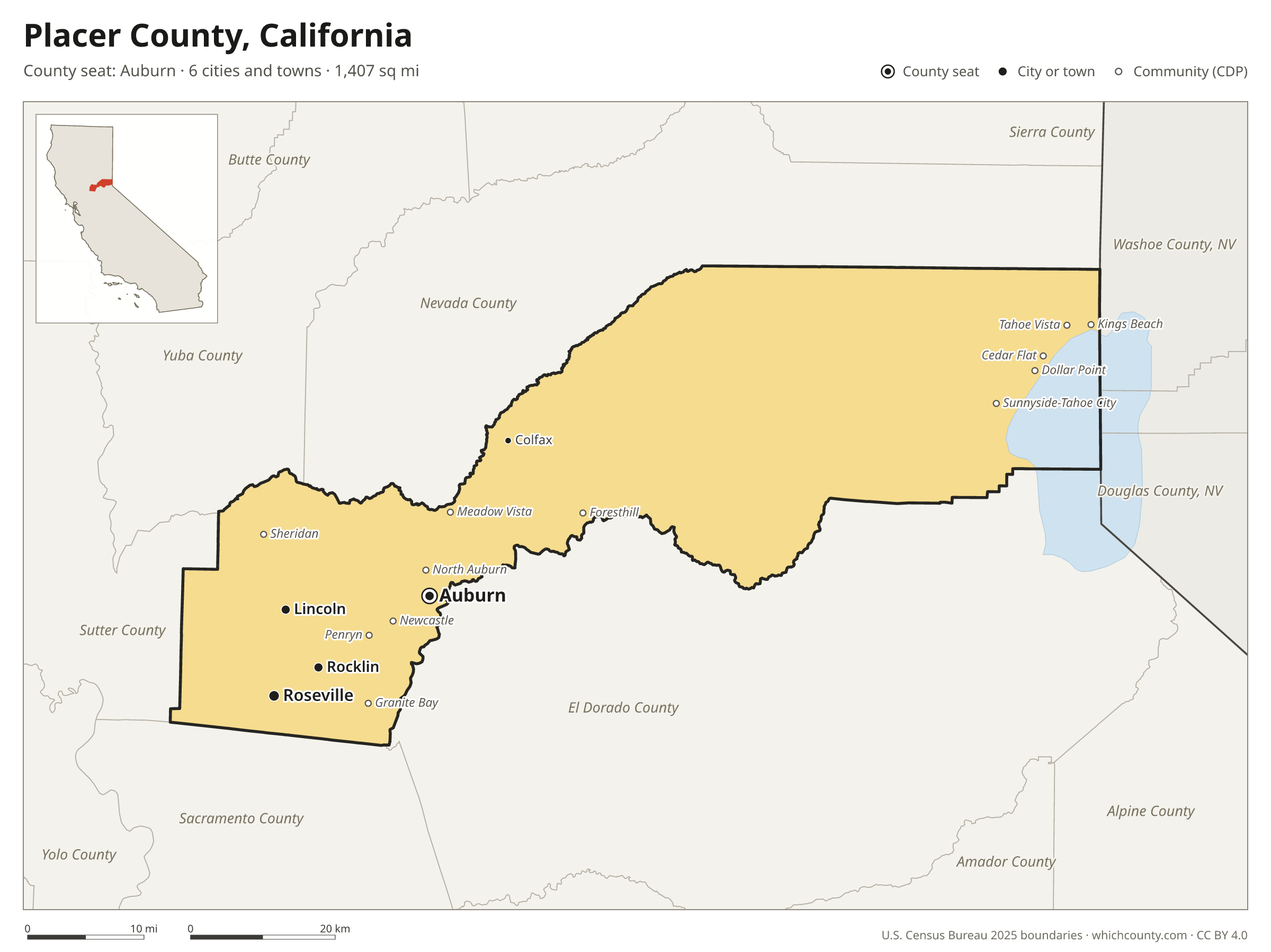
Placer County is the 20th most populous of California's 58 counties, with 442,081 people (2025 estimate). Its county seat is Auburn. The map shows its 6 cities and towns and the 8 neighboring counties.

Placer County facts
- County seat
- Auburn
- Population (2025 estimate)
- 442,081 +9.2% since 2020
- Land area
- 1,407 sq mi 32nd largest of 58
- Water area
- 95 sq mi
- Population density
- 314 per sq mi
- Established
- 1851
- Named after
- placer mining technique of mining stream bed deposits for minerals
- Largest city
- Roseville 167,302
- Median household income
- $115,998
- Cities and towns
- 6 plus 17 CDPs
- ZIP codes
- 34
- Time zone
- Pacific
- FIPS code
- 06061
Cities and towns in Placer County
Placer County has 6 incorporated cities, towns and villages. Populations count the people living inside Placer County; cities that cross a county line also list the other counties.
| Name | Type | Population 2025 | Also in |
|---|---|---|---|
| Roseville | City | 167,302 | |
| Rocklin | City | 76,821 | |
| Lincoln | City | 57,367 | |
| Auburn (county seat) | City | 13,847 | |
| Loomis | Town | 7,004 | |
| Colfax | City | 2,043 |
Unincorporated communities (CDPs)
Census-designated places are communities without their own city government; the county provides their services.
| Community | Population | Also in |
|---|---|---|
| Granite Bay | 21,673 | |
| North Auburn | 13,480 | |
| Meadow Vista | 3,162 | |
| Kings Beach | 2,736 | |
| Sunnyside-Tahoe City | 1,599 | |
| Newcastle | 1,585 | |
| Foresthill | 1,483 | |
| Dollar Point | 1,477 | |
| Sheridan | 1,183 | |
| Penryn | 1,114 | |
| Cedar Flat | 1,089 | |
| Tahoe Vista | 1,048 | |
| Alta | 656 | |
| Carnelian Bay | 391 | |
| Tahoma | 225 | El Dorado County |
| Dutch Flat | 200 | |
| Kingvale | 0 | Nevada County |
ZIP codes in Placer County
34 ZIP codes reach into Placer County. ZIP codes ignore county lines, so some also cover a neighboring county.
- 95602 also Nevada County
- 95603 also El Dorado County
- 95604
- 95626 also Sacramento and Sutter counties
- 95631
- 95648
- 95650
- 95658
- 95661
- 95663
- 95668 also Sutter County
- 95677
- 95678 also Sacramento County
- 95681
- 95701
- 95703
- 95713
- 95714
- 95715
- 95717
- 95722
- 95728 also Nevada County
- 95736
- 95746
- 95747
- 95765
- 96140
- 96141
- 96142 also El Dorado County
- 96143
- 96145
- 96146
- 96148
- 96161 also Nevada County
Population of Placer County, 2020–2025
Placer County grew by 37,314 people (+9.2%) between April 2020 and July 2025: 213 more deaths than births and a net gain of 37,715 people from migration.
| Year (July 1) | Population |
|---|---|
| 2020 | 405,971 |
| 2021 | 413,038 |
| 2022 | 418,469 |
| 2023 | 425,195 |
| 2024 | 434,279 |
| 2025 | 442,081 |
Neighboring counties
- El Dorado County southeast · 192,323 people
- Nevada County north · 101,911 people
- Sutter County west · 98,787 people
- Sacramento County southwest · 1,618,460 people
- Washoe County, Nevada northeast · 509,386 people
- Yuba County northwest · 88,691 people
- Carson City, Nevada east · 58,571 people
- Douglas County, Nevada east · 50,111 people
Printable Placer County map
The PDF is a vector file with real text: it prints sharp on Letter paper and you can search it for a town. The PNG is 2400 pixels wide for slides and documents. Both are free to use with a credit to WhichCounty.
- PDF (Letter) (202 KB)
- PNG (2400 px) (114 KB)
Paste this code to embed the map on your site:
Sources
- Boundaries: U.S. Census Bureau, 2025 Cartographic Boundary Files (1:500,000).
- Population: Census Bureau county and city estimates, Vintage 2025. CDP populations: American Community Survey 2020–2024.
- Places and ZIP codes: Census Bureau 2026 Gazetteer and 2020 ZIP Code Tabulation Area relationship files.
- County seat, founding year and name origin: Wikidata (CC0), checked against state sources.
Back to the California county map with all 58 counties. Found an error? Tell us.