Sonoma County, California
County seat: Santa Rosa · Population 486,444 (2025) · 1,575 sq mi
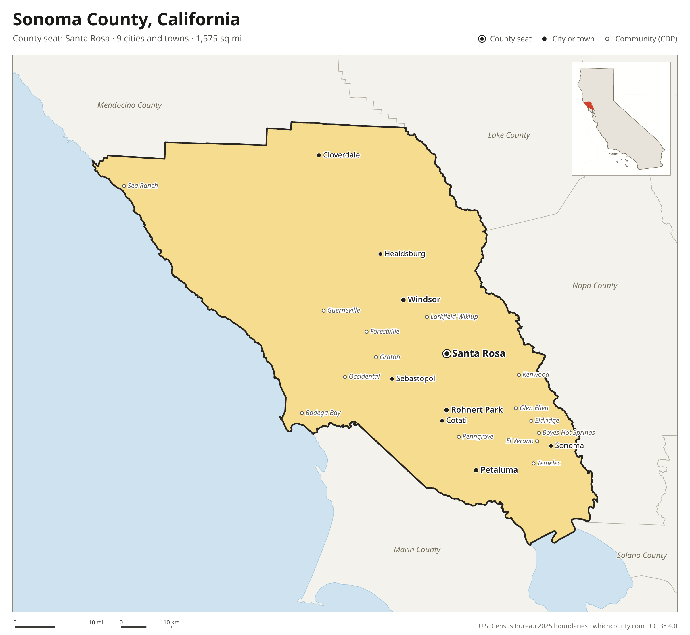
Sonoma County is the 17th most populous of California's 58 counties, with 486,444 people (2025 estimate). Its county seat is Santa Rosa. The map shows its 9 cities and towns and the 6 neighboring counties.

Sonoma County facts
- County seat
- Santa Rosa
- Population (2025 estimate)
- 486,444 −0.5% since 2020
- Land area
- 1,575 sq mi 29th largest of 58
- Water area
- 192 sq mi
- Population density
- 309 per sq mi
- Established
- 1850
- Named after
- Sonoma city in Sonoma County, California, United States
- Largest city
- Santa Rosa 179,437
- Median household income
- $104,674
- Cities and towns
- 9 plus 29 CDPs
- ZIP codes
- 40
- Time zone
- Pacific
- FIPS code
- 06097
Cities and towns in Sonoma County
Sonoma County has 9 incorporated cities, towns and villages. Populations count the people living inside Sonoma County; cities that cross a county line also list the other counties.
| Name | Type | Population 2025 | Also in |
|---|---|---|---|
| Santa Rosa (county seat) | City | 179,437 | |
| Petaluma | City | 59,688 | |
| Rohnert Park | City | 44,811 | |
| Windsor | Town | 25,864 | |
| Healdsburg | City | 11,172 | |
| Sonoma | City | 10,537 | |
| Cloverdale | City | 8,701 | |
| Sebastopol | City | 7,532 | |
| Cotati | City | 7,347 |
Unincorporated communities (CDPs)
Census-designated places are communities without their own city government; the county provides their services.
| Community | Population | Also in |
|---|---|---|
| Larkfield-Wikiup | 8,765 | |
| Boyes Hot Springs | 7,247 | |
| Guerneville | 4,100 | |
| Forestville | 3,717 | |
| El Verano | 3,443 | |
| Fetters Hot Springs-Agua Caliente | 3,347 | |
| Sonoma State University | 2,210 | |
| Penngrove | 2,119 | |
| Graton | 1,806 | |
| Temelec | 1,628 | |
| Eldridge | 1,379 | |
| Sea Ranch | 1,287 | |
| Occidental | 1,225 | |
| Bodega Bay | 1,139 | |
| Glen Ellen | 1,078 | |
| Kenwood | 1,028 | |
| Monte Rio | 876 | |
| Petaluma Center | 763 | |
| Geyserville | 672 | |
| Cazadero | 483 | |
| Fulton | 453 | |
| Bloomfield | 324 | |
| Timber Cove | 199 | |
| Bodega | 134 | |
| Sereno del Mar | 101 | |
| Carmet | 85 | |
| Salmon Creek | 40 | |
| Jenner | 18 | |
| Valley Ford | 0 |
ZIP codes in Sonoma County
40 ZIP codes reach into Sonoma County. ZIP codes ignore county lines, so some also cover a neighboring county.
- 94515 also Napa County
- 94574 also Napa County
- 94922
- 94923
- 94928
- 94931
- 94951
- 94952 also Marin County
- 94954
- 94972
- 95401
- 95403
- 95404
- 95405
- 95407
- 95409
- 95412
- 95419
- 95421
- 95425 also Mendocino County
- 95430
- 95431
- 95436
- 95439
- 95441
- 95442
- 95444
- 95446
- 95448
- 95450
- 95452
- 95462
- 95465
- 95471
- 95472
- 95476 also Napa County
- 95480
- 95486
- 95492
- 95497
Population of Sonoma County, 2020–2025
Sonoma County shrank by 2,416 people (−0.5%) between April 2020 and July 2025: 137 more deaths than births and a net loss of 2,112 people from migration.
| Year (July 1) | Population |
|---|---|
| 2020 | 488,514 |
| 2021 | 484,827 |
| 2022 | 483,236 |
| 2023 | 483,405 |
| 2024 | 485,363 |
| 2025 | 486,444 |
Neighboring counties
- Napa County east · 132,949 people
- Marin County south · 253,694 people
- Mendocino County northwest · 88,122 people
- Lake County north · 67,772 people
- Solano County east · 455,376 people
- Contra Costa County southeast · 1,170,070 people
Printable Sonoma County map
The PDF is a vector file with real text: it prints sharp on Letter paper and you can search it for a town. The PNG is 2400 pixels wide for slides and documents. Both are free to use with a credit to WhichCounty.
- PDF (Letter) (171 KB)
- PNG (2400 px) (111 KB)
Paste this code to embed the map on your site:
Sources
- Boundaries: U.S. Census Bureau, 2025 Cartographic Boundary Files (1:500,000).
- Population: Census Bureau county and city estimates, Vintage 2025. CDP populations: American Community Survey 2020–2024.
- Places and ZIP codes: Census Bureau 2026 Gazetteer and 2020 ZIP Code Tabulation Area relationship files.
- County seat, founding year and name origin: Wikidata (CC0), checked against state sources.
Back to the California county map with all 58 counties. Found an error? Tell us.