Stanislaus County, California
County seat: Modesto · Population 557,719 (2025) · 1,496 sq mi
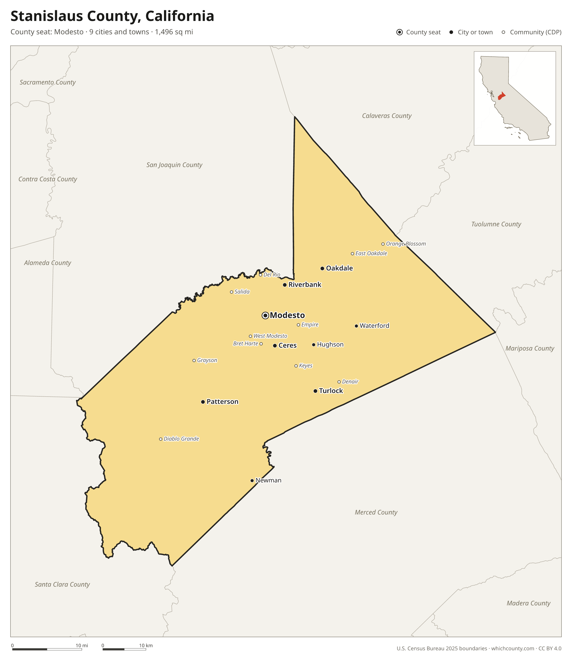
Stanislaus County is the 16th most populous of California's 58 counties, with 557,719 people (2025 estimate). Its county seat is Modesto. The map shows its 9 cities and towns and the 7 neighboring counties.

Stanislaus County facts
- County seat
- Modesto
- Population (2025 estimate)
- 557,719 +0.8% since 2020
- Land area
- 1,496 sq mi 30th largest of 58
- Water area
- 18 sq mi
- Population density
- 373 per sq mi
- Established
- 1854
- Named after
- Estanislao Leader of the Lakisamni tribe
- Largest city
- Modesto 219,652
- Median household income
- $81,468
- Cities and towns
- 9 plus 24 CDPs
- ZIP codes
- 28
- Time zone
- Pacific
- FIPS code
- 06099
Cities and towns in Stanislaus County
Stanislaus County has 9 incorporated cities, towns and villages. Populations count the people living inside Stanislaus County; cities that cross a county line also list the other counties.
| Name | Type | Population 2025 | Also in |
|---|---|---|---|
| Modesto (county seat) | City | 219,652 | |
| Turlock | City | 72,864 | |
| Ceres | City | 48,982 | |
| Patterson | City | 26,587 | |
| Riverbank | City | 26,557 | |
| Oakdale | City | 23,246 | |
| Newman | City | 12,453 | |
| Waterford | City | 9,258 | |
| Hughson | City | 8,051 |
Unincorporated communities (CDPs)
Census-designated places are communities without their own city government; the county provides their services.
| Community | Population | Also in |
|---|---|---|
| Salida | 13,900 | |
| West Modesto | 5,978 | |
| Keyes | 5,577 | |
| Denair | 4,914 | |
| Bret Harte | 4,757 | |
| Bystrom | 4,143 | |
| Empire | 3,429 | |
| East Oakdale | 2,269 | |
| Diablo Grande | 1,948 | |
| Del Rio | 1,508 | |
| Parklawn | 1,478 | |
| Rouse | 1,462 | |
| Grayson | 1,182 | |
| Riverdale Park | 1,137 | |
| Orange Blossom | 1,062 | |
| Airport | 903 | |
| Hickman | 844 | |
| Westley | 572 | |
| Cowan | 497 | |
| Crows Landing | 335 | |
| Valley Home | 328 | |
| La Grange | 91 | |
| Monterey Park Tract | 74 | |
| Knights Ferry | 64 |
ZIP codes in Stanislaus County
28 ZIP codes reach into Stanislaus County. ZIP codes ignore county lines, so some also cover a neighboring county.
- 95230 also Calaveras and San Joaquin counties
- 95304 also San Joaquin County
- 95307
- 95313
- 95316 also Merced County
- 95319
- 95322 also Merced County
- 95323
- 95326
- 95328
- 95329 also Tuolumne and Mariposa counties
- 95350
- 95351
- 95354
- 95355
- 95356
- 95357
- 95358
- 95360 also Merced County
- 95361 also San Joaquin County
- 95363
- 95367
- 95368
- 95380 also Merced County
- 95382
- 95385 also San Joaquin County
- 95386
- 95387
Population of Stanislaus County, 2020–2025
Stanislaus County grew by 4,435 people (+0.8%) between April 2020 and July 2025: 10,115 more births than deaths and a net loss of 6,054 people from migration.
| Year (July 1) | Population |
|---|---|
| 2020 | 553,702 |
| 2021 | 553,047 |
| 2022 | 552,453 |
| 2023 | 554,459 |
| 2024 | 557,372 |
| 2025 | 557,719 |
Neighboring counties
- San Joaquin County northwest · 823,815 people
- Merced County southeast · 297,260 people
- Santa Clara County southwest · 1,914,391 people
- Calaveras County northeast · 46,605 people
- Tuolumne County northeast · 53,160 people
- Alameda County west · 1,636,630 people
- Mariposa County east · 16,918 people
Printable Stanislaus County map
The PDF is a vector file with real text: it prints sharp on Letter paper and you can search it for a town. The PNG is 2400 pixels wide for slides and documents. Both are free to use with a credit to WhichCounty.
- PDF (Letter) (191 KB)
- PNG (2400 px) (124 KB)
Paste this code to embed the map on your site:
Sources
- Boundaries: U.S. Census Bureau, 2025 Cartographic Boundary Files (1:500,000).
- Population: Census Bureau county and city estimates, Vintage 2025. CDP populations: American Community Survey 2020–2024.
- Places and ZIP codes: Census Bureau 2026 Gazetteer and 2020 ZIP Code Tabulation Area relationship files.
- County seat, founding year and name origin: Wikidata (CC0), checked against state sources.
Back to the California county map with all 58 counties. Found an error? Tell us.