Adams County, Colorado
County seat: Brighton · Population 554,668 (2025) · 1,167 sq mi
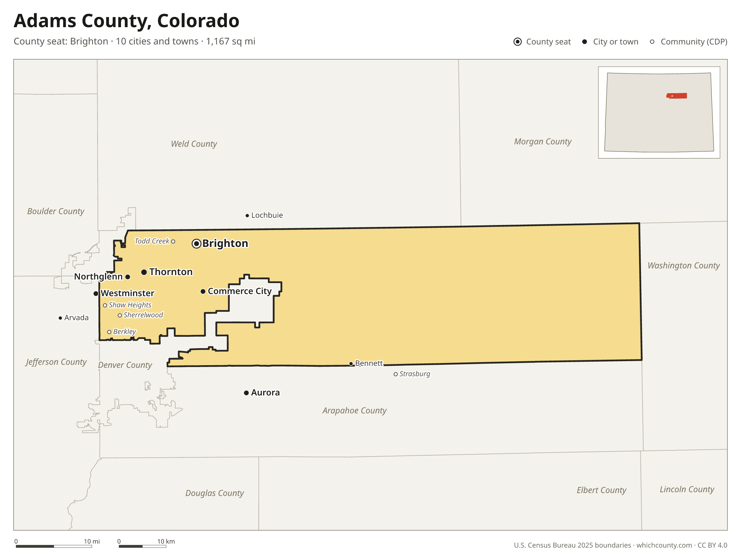
Adams County is the 5th most populous of Colorado's 64 counties, with 554,668 people (2025 estimate). Its county seat is Brighton. It is part of the Region 3: Denver Metropolitan Area region, one of the 14 Planning and Management Regions of Colorado. The map shows its 10 cities and towns and the 7 neighboring counties.

Adams County facts
- County seat
- Brighton
- Population (2025 estimate)
- 554,668 +6.8% since 2020
- Land area
- 1,167 sq mi 39th largest of 64
- Water area
- 17 sq mi
- Population density
- 475 per sq mi
- Established
- 1902
- Same name
- One of 12 Adams Counties in the US
- Named after
- Alva Adams American politician (1850-1922)
- Largest city
- Thornton 147,766 in the county
- Median household income
- $94,571
- Cities and towns
- 10 plus 10 CDPs
- ZIP codes
- 35
- Time zone
- Mountain
- FIPS code
- 08001
Cities and towns in Adams County
Adams County has 10 incorporated cities, towns and villages. Populations count the people living inside Adams County; cities that cross a county line also list the other counties.
| Name | Type | Population 2025 | Also in |
|---|---|---|---|
| Thornton | City | 147,766 | Weld County |
| Commerce City | City | 72,345 | |
| Westminster | City | 70,485 | Jefferson County |
| Aurora | City | 61,110 | Arapahoe and Douglas counties |
| Brighton (county seat) | City | 44,934 | Weld County |
| Northglenn | City | 38,869 | Weld County |
| Federal Heights | City | 14,075 | |
| Bennett | Town | 3,777 | Arapahoe County |
| Arvada | City | 2,793 | Jefferson County |
| Lochbuie | Town | 0 | Weld County |
Unincorporated communities (CDPs)
Census-designated places are communities without their own city government; the county provides their services.
| Community | Population | Also in |
|---|---|---|
| Sherrelwood | 18,692 | |
| Welby | 16,197 | |
| Berkley | 10,789 | |
| Derby | 8,453 | |
| Twin Lakes | 8,030 | |
| Shaw Heights | 5,565 | |
| Todd Creek | 5,379 | |
| Strasburg | 2,171 | Arapahoe County |
| North Washington | 294 | |
| Watkins | 63 | Arapahoe County |
ZIP codes in Adams County
35 ZIP codes reach into Adams County. ZIP codes ignore county lines, so some also cover a neighboring county.
- 80002 also Jefferson County
- 80003 also Jefferson County
- 80010 also Arapahoe County
- 80011 also Arapahoe County
- 80019
- 80020 also Broomfield, Boulder and Jefferson counties
- 80022
- 80023 also Broomfield County
- 80024
- 80030
- 80031 also Jefferson County
- 80045
- 80102 also Arapahoe and Elbert counties
- 80103 also Arapahoe County
- 80105 also Arapahoe and Elbert counties
- 80136 also Arapahoe County
- 80137 also Arapahoe County
- 80212 also Denver and Jefferson counties
- 80216 also Denver County
- 80220 also Denver and Arapahoe counties
- 80221 also Denver County
- 80229
- 80233
- 80234 also Broomfield County
- 80239 also Denver County
- 80241
- 80260
- 80601 also Weld County
- 80602
- 80603 also Weld County
- 80640
- 80642 also Weld County
- 80643 also Weld County
- 80654 also Morgan and Weld counties
- 80701 also Morgan County
Population of Adams County, 2020–2025
Adams County grew by 35,088 people (+6.8%) between April 2020 and July 2025: 14,545 more births than deaths and a net gain of 20,049 people from migration.
| Year (July 1) | Population |
|---|---|
| 2020 | 520,411 |
| 2021 | 523,159 |
| 2022 | 528,035 |
| 2023 | 537,158 |
| 2024 | 549,257 |
| 2025 | 554,668 |
Neighboring counties
- Denver County west · 740,613 people
- Arapahoe County south · 673,820 people
- Weld County north · 378,426 people
- Morgan County northeast · 30,306 people
- Washington County east · 4,732 people
- Broomfield County west · 79,174 people
- Jefferson County southwest · 580,451 people
Printable Adams County map
The PDF is a vector file with real text: it prints sharp on Letter paper and you can search it for a town. The PNG is 2400 pixels wide for slides and documents. Both are free to use with a credit to WhichCounty.
- PDF (Letter) (123 KB)
- PNG (2400 px) (80 KB)
Paste this code to embed the map on your site:
Sources
- Boundaries: U.S. Census Bureau, 2025 Cartographic Boundary Files (1:500,000).
- Population: Census Bureau county and city estimates, Vintage 2025. CDP populations: American Community Survey 2020–2024.
- Places and ZIP codes: Census Bureau 2026 Gazetteer and 2020 ZIP Code Tabulation Area relationship files.
- County seat, founding year and name origin: Wikidata (CC0), checked against state sources.
Back to the Colorado county map with all 64 counties. Found an error? Tell us.