Jefferson County, Colorado
County seat: Golden · Population 580,451 (2025) · 764 sq mi
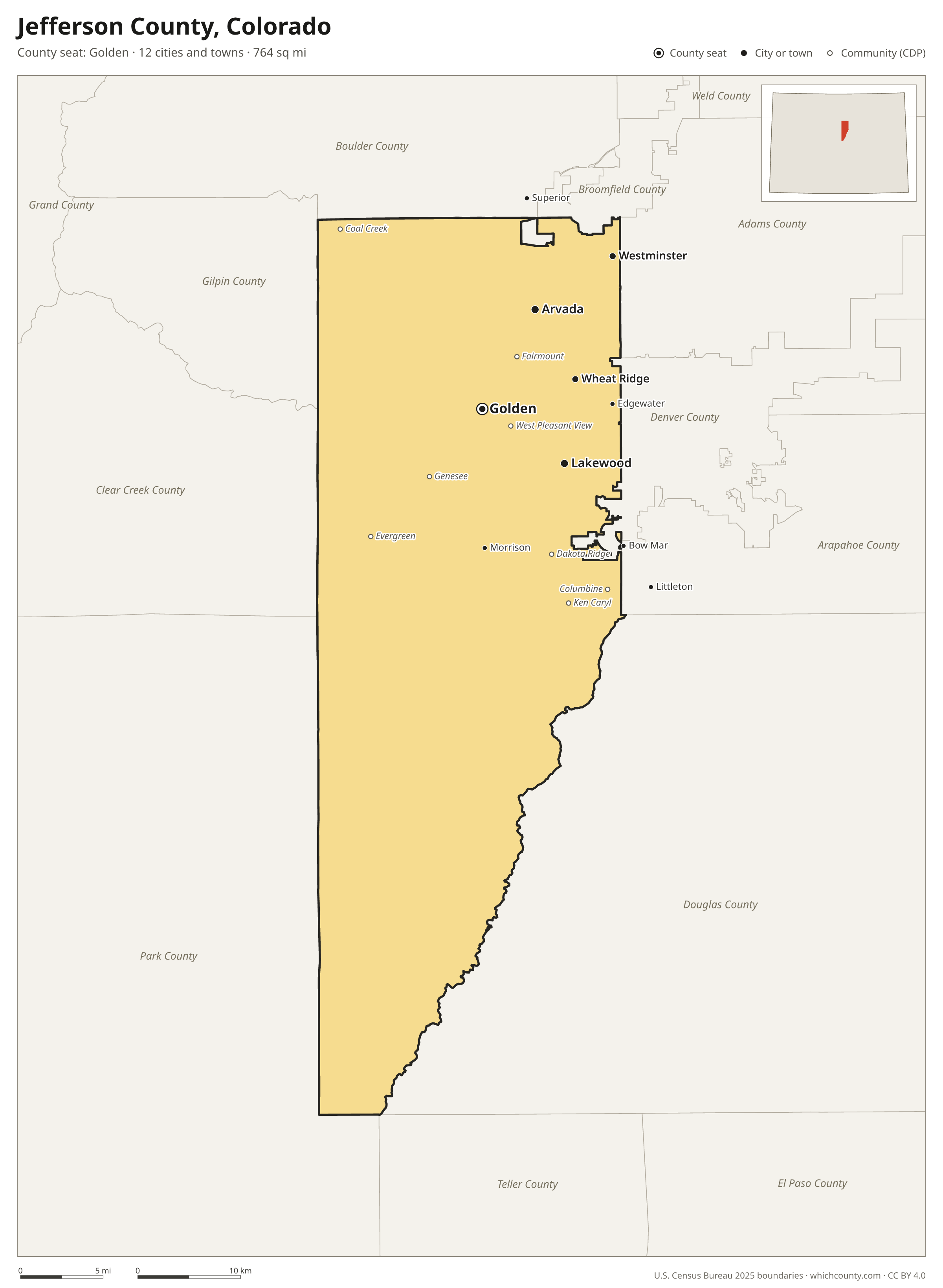
Jefferson County is the 4th most populous of Colorado's 64 counties, with 580,451 people (2025 estimate). Its county seat is Golden. It is part of the Region 3: Denver Metropolitan Area region, one of the 14 Planning and Management Regions of Colorado. The map shows its 12 cities and towns and the 10 neighboring counties.

Jefferson County facts
- County seat
- Golden
- Population (2025 estimate)
- 580,451 −0.4% since 2020
- Land area
- 764 sq mi 50th largest of 64
- Water area
- 10 sq mi
- Population density
- 759 per sq mi
- Established
- 1861
- Same name
- One of 25 Jefferson Counties in the US
- Named after
- Thomas Jefferson Founding Father, U.S. president from 1801 to 1809 (1743–1826)
- Largest city
- Lakewood 156,927
- Median household income
- $110,656
- Cities and towns
- 12 plus 15 CDPs
- ZIP codes
- 34
- Time zone
- Mountain
- FIPS code
- 08059
Cities and towns in Jefferson County
Jefferson County has 12 incorporated cities, towns and villages. Populations count the people living inside Jefferson County; cities that cross a county line also list the other counties.
| Name | Type | Population 2025 | Also in |
|---|---|---|---|
| Lakewood | City | 156,927 | |
| Arvada | City | 120,108 | Adams County |
| Westminster | City | 45,697 | Adams County |
| Wheat Ridge | City | 32,081 | |
| Golden (county seat) | City | 20,390 | |
| Edgewater | City | 4,870 | |
| Littleton | City | 2,202 | Arapahoe and Douglas counties |
| Mountain View | Town | 517 | |
| Morrison | Town | 364 | |
| Bow Mar | Town | 256 | Arapahoe County |
| Lakeside | Town | 16 | |
| Superior | Town | 0 | Boulder County |
Unincorporated communities (CDPs)
Census-designated places are communities without their own city government; the county provides their services.
| Community | Population | Also in |
|---|---|---|
| Dakota Ridge | 33,753 | |
| Ken Caryl | 33,233 | |
| Columbine | 23,444 | Arapahoe County |
| Fairmount | 9,902 | |
| Evergreen | 8,602 | |
| Applewood | 8,350 | |
| West Pleasant View | 5,051 | |
| Genesee | 3,778 | |
| Coal Creek | 1,418 | Boulder and Gilpin counties |
| Indian Hills | 986 | |
| East Pleasant View | 832 | |
| Kittredge | 812 | |
| Aspen Park | 742 | |
| Idledale | 297 | |
| Brook Forest | 171 | Clear Creek County |
ZIP codes in Jefferson County
34 ZIP codes reach into Jefferson County. ZIP codes ignore county lines, so some also cover a neighboring county.
- 80002 also Adams County
- 80003 also Adams County
- 80004
- 80005
- 80007
- 80020 also Broomfield, Boulder and Adams counties
- 80021 also Broomfield County
- 80031 also Adams County
- 80033
- 80123 also Arapahoe and Denver counties
- 80125 also Douglas County
- 80127
- 80128 also Arapahoe County
- 80135 also Douglas County
- 80212 also Denver and Adams counties
- 80214 also Denver County
- 80215
- 80226 also Denver County
- 80227 also Denver County
- 80228
- 80232 also Denver County
- 80235 also Denver County
- 80401
- 80403 also Gilpin and Boulder counties
- 80419
- 80421 also Park County
- 80425
- 80433
- 80439 also Clear Creek County
- 80453
- 80454
- 80457
- 80465
- 80470 also Park County
Population of Jefferson County, 2020–2025
Jefferson County shrank by 2,478 people (−0.4%) between April 2020 and July 2025: 2,046 more births than deaths and a net loss of 4,719 people from migration.
| Year (July 1) | Population |
|---|---|
| 2020 | 583,131 |
| 2021 | 581,002 |
| 2022 | 576,703 |
| 2023 | 578,084 |
| 2024 | 580,359 |
| 2025 | 580,451 |
Neighboring counties
- Douglas County southeast · 399,396 people
- Park County southwest · 18,314 people
- Denver County northeast · 740,613 people
- Broomfield County north · 79,174 people
- Boulder County north · 328,560 people
- Clear Creek County west · 8,994 people
- Gilpin County northwest · 6,073 people
- Adams County northeast · 554,668 people
- Arapahoe County east · 673,820 people
- Teller County south · 24,756 people
Printable Jefferson County map
The PDF is a vector file with real text: it prints sharp on Letter paper and you can search it for a town. The PNG is 2400 pixels wide for slides and documents. Both are free to use with a credit to WhichCounty.
- PDF (Letter) (159 KB)
- PNG (2400 px) (115 KB)
Paste this code to embed the map on your site:
Sources
- Boundaries: U.S. Census Bureau, 2025 Cartographic Boundary Files (1:500,000).
- Population: Census Bureau county and city estimates, Vintage 2025. CDP populations: American Community Survey 2020–2024.
- Places and ZIP codes: Census Bureau 2026 Gazetteer and 2020 ZIP Code Tabulation Area relationship files.
- County seat, founding year and name origin: Wikidata (CC0), checked against state sources.
Back to the Colorado county map with all 64 counties. Found an error? Tell us.