Capitol Planning Region, Connecticut
Population 994,115 (2025) · 1,027 sq mi
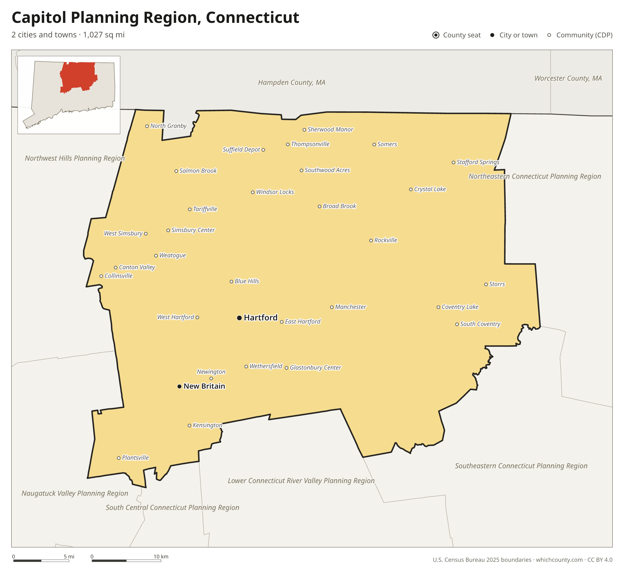
Capitol Planning Region is the most populous of Connecticut's 9 planning regions, with 994,115 people (2025 estimate). The map shows its 2 cities and towns and the 7 neighboring counties.

Capitol Planning Region facts
- Population (2025 estimate)
- 994,115 +1.7% since 2020
- Land area
- 1,027 sq mi 1st largest of 9
- Water area
- 19 sq mi
- Population density
- 968 per sq mi
- Largest city
- Hartford 121,981
- Median household income
- $93,394
- Cities and towns
- 2 plus 33 CDPs
- ZIP codes
- 74
- Time zone
- Eastern
- FIPS code
- 09110
Cities and towns in Capitol Planning Region
Capitol Planning Region has 2 incorporated cities, towns and villages. Populations count the people living inside Capitol Planning Region; cities that cross a county line also list the other counties.
| Name | Type | Population 2025 | Also in |
|---|---|---|---|
| Hartford | City | 121,981 | |
| New Britain | City | 76,286 |
Unincorporated communities (CDPs)
Census-designated places are communities without their own city government; the county provides their services.
| Community | Population | Also in |
|---|---|---|
| West Hartford | 63,620 | |
| East Hartford | 50,918 | |
| Manchester | 36,759 | |
| Newington | 30,896 | |
| Wethersfield | 27,250 | |
| Storrs | 15,207 | |
| Windsor Locks | 12,579 | |
| Kensington | 9,962 | |
| Southwood Acres | 8,115 | |
| Thompsonville | 7,927 | |
| Glastonbury Center | 7,266 | |
| Rockville | 7,072 | |
| Simsbury Center | 6,198 | |
| Hazardville | 6,022 | |
| Sherwood Manor | 5,706 | |
| Stafford Springs | 4,649 | |
| Collinsville | 3,963 | |
| Broad Brook | 3,609 | |
| West Simsbury | 3,000 | |
| Weatogue | 2,672 | |
| Coventry Lake | 2,647 | |
| Salmon Brook | 2,343 | |
| Plantsville | 2,220 | |
| Somers | 2,056 | |
| Crystal Lake | 2,024 | |
| Suffield Depot | 2,006 | |
| Blue Hills | 1,676 | |
| North Granby | 1,451 | |
| South Coventry | 1,434 | |
| Tariffville | 1,419 | |
| Canton Valley | 1,186 | |
| Terramuggus | 968 | |
| Mansfield Center | 785 |
ZIP codes in Capitol Planning Region
74 ZIP codes reach into Capitol Planning Region. ZIP codes ignore county lines, so some also cover a neighboring county.
- 06001
- 06002
- 06010 also Naugatuck Valley Planning Region
- 06016
- 06019
- 06020
- 06022
- 06023
- 06026
- 06029
- 06032
- 06033
- 06035
- 06037
- 06040
- 06042
- 06043
- 06051
- 06052
- 06053
- 06059
- 06060
- 06062 also Naugatuck Valley Planning Region
- 06066
- 06067
- 06070
- 06071
- 06072
- 06073
- 06074
- 06076 also Northeastern Connecticut Planning Region
- 06078
- 06080
- 06081
- 06082
- 06084
- 06085
- 06088
- 06089
- 06090
- 06092
- 06093
- 06095
- 06096
- 06103
- 06105
- 06106
- 06107
- 06108
- 06109
- 06110
- 06111
- 06112
- 06114
- 06117
- 06118
- 06119
- 06120
- 06226 also Southeastern Connecticut Planning Region
- 06231
- 06232
- 06237
- 06238
- 06248
- 06250 also Northeastern Connecticut Planning Region
- 06268
- 06269
- 06279
- 06444
- 06447
- 06451 also South Central Connecticut Planning Region
- 06467
- 06479
- 06489
Population of Capitol Planning Region, 2020–2025
Capitol Planning Region grew by 16,429 people (+1.7%) between April 2020 and July 2025: 1,249 more deaths than births and a net gain of 20,349 people from migration.
| Year (July 1) | Population |
|---|---|
| 2020 | 964,034 |
| 2021 | 971,972 |
| 2022 | 975,074 |
| 2023 | 981,775 |
| 2024 | 989,194 |
| 2025 | 994,115 |
Neighboring counties
- Hampden County, Massachusetts north · 464,338 people
- Southeastern Connecticut Planning Region southeast · 284,015 people
- Northwest Hills Planning Region west · 114,690 people
- Northeastern Connecticut Planning Region east · 98,096 people
- Lower Connecticut River Valley Planning Region south · 177,311 people
- Naugatuck Valley Planning Region southwest · 463,349 people
- South Central Connecticut Planning Region south · 578,741 people
Printable Capitol Planning Region map
The PDF is a vector file with real text: it prints sharp on Letter paper and you can search it for a town. The PNG is 2400 pixels wide for slides and documents. Both are free to use with a credit to WhichCounty.
- PDF (Letter) (224 KB)
- PNG (2400 px) (134 KB)
Paste this code to embed the map on your site:
Cite this map
- APA
- WhichCounty. (2026, October 4). Capitol Planning Region, Connecticut Map [Map]. https://whichcounty.com/connecticut/capitol-planning-region/
- MLA
- “Capitol Planning Region, Connecticut Map.” WhichCounty, 4 Oct. 2026, whichcounty.com/connecticut/capitol-planning-region/.
- Chicago
- WhichCounty. “Capitol Planning Region, Connecticut Map.” Last modified October 4, 2026. https://whichcounty.com/connecticut/capitol-planning-region/.
Sources
- Boundaries: U.S. Census Bureau, 2025 Cartographic Boundary Files (1:500,000).
- Population: Census Bureau county and city estimates, Vintage 2025. CDP populations: American Community Survey 2020–2024.
- Places and ZIP codes: Census Bureau 2026 Gazetteer and 2020 ZIP Code Tabulation Area relationship files.
- County seat, founding year and name origin: Wikidata (CC0), checked against state sources.
Back to the Connecticut county map with all 9 planning regions. Found an error? Tell us.