Washington County, Maryland
County seat: Hagerstown · Population 157,731 (2025) · 458 sq mi
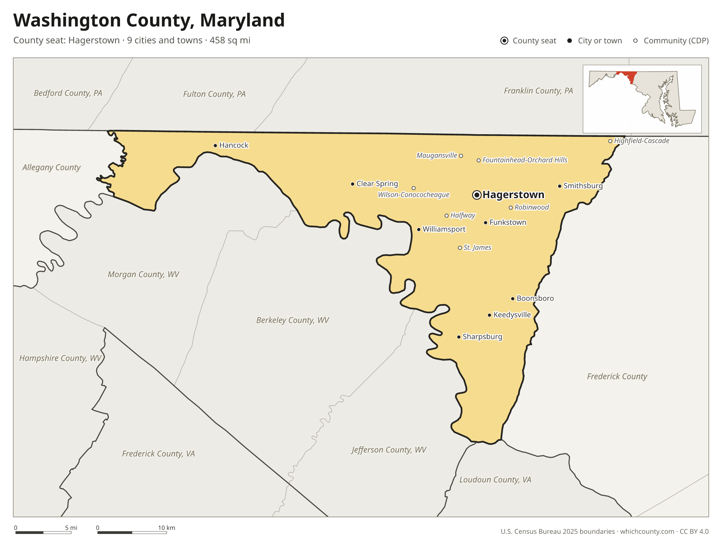
Washington County is the 11th most populous of Maryland's 24 counties, with 157,731 people (2025 estimate). Its county seat is Hagerstown. The map shows its 9 cities and towns and the 8 neighboring counties.

Washington County facts
- County seat
- Hagerstown
- Population (2025 estimate)
- 157,731 +2% since 2020
- Land area
- 458 sq mi 9th largest of 24
- Water area
- 10 sq mi
- Population density
- 345 per sq mi
- Established
- 1776
- Same name
- One of 30 Washington Counties in the US
- Named after
- George Washington Founding Father and first U.S. president (1732–1799)
- Largest city
- Hagerstown 44,228
- Median household income
- $77,747
- Cities and towns
- 9 plus 52 CDPs
- ZIP codes
- 21
- Time zone
- Eastern
- FIPS code
- 24043
Cities and towns in Washington County
Washington County has 9 incorporated cities, towns and villages. Populations count the people living inside Washington County; cities that cross a county line also list the other counties.
| Name | Type | Population 2025 | Also in |
|---|---|---|---|
| Hagerstown (county seat) | City | 44,228 | |
| Boonsboro | Town | 3,867 | |
| Smithsburg | Town | 3,212 | |
| Williamsport | Town | 2,112 | |
| Hancock | Town | 1,581 | |
| Keedysville | Town | 1,225 | |
| Funkstown | Town | 863 | |
| Sharpsburg | Town | 573 | |
| Clear Spring | Town | 378 |
Unincorporated communities (CDPs)
Census-designated places are communities without their own city government; the county provides their services.
| Community | Population | Also in |
|---|---|---|
| Halfway | 10,849 | |
| Robinwood | 8,042 | |
| Fountainhead-Orchard Hills | 6,567 | |
| St. James | 4,824 | |
| Maugansville | 3,624 | |
| Paramount-Long Meadow | 2,569 | |
| Wilson-Conococheague | 1,663 | |
| Highfield-Cascade | 1,089 | |
| Downsville | 958 | |
| Cavetown | 858 | |
| Mount Aetna | 637 | |
| Fairplay | 511 | |
| Leitersburg | 498 | |
| Beaver Creek | 439 | |
| Pinesburg | 409 | |
| Mount Lena | 391 | |
| Mapleville | 365 | |
| Chewsville | 314 | |
| Greensburg | 314 | |
| Bagtown | 310 | |
| San Mar | 306 | |
| Tilghmanton | 282 | |
| Garretts Mill | 244 | |
| Mercersville | 220 | |
| Trego-Rohrersville Station | 209 | |
| Mount Briar | 201 | |
| Pecktonville | 179 | |
| Sandy Hook | 165 | |
| Ringgold | 153 | |
| Breathedsville | 147 | |
| Rohrersville | 141 | |
| Dargan | 135 | |
| Reid | 120 | |
| Edgemont | 107 | |
| Pondsville | 102 | |
| Jugtown | 97 | |
| Cearfoss | 86 | |
| Yarrowsburg | 83 | |
| Indian Springs | 61 | |
| Antietam | 50 | |
| Kemps Mill | 49 | |
| Big Pool | 41 | |
| Gapland | 26 | |
| Big Spring | 21 | |
| Brownsville | 20 | |
| Bakersville | 0 | |
| Charlton | 0 | |
| Eakles Mill | 0 | |
| Ernstville | 0 | |
| Fairview | 0 | |
| Fort Ritchie | 0 | |
| Middleburg | 0 |
ZIP codes in Washington County
21 ZIP codes reach into Washington County. ZIP codes ignore county lines, so some also cover a neighboring county.
- 21711
- 21713
- 21715
- 21719 also Frederick County
- 21722
- 21733
- 21734
- 21740
- 21742
- 21746
- 21750
- 21756
- 21758 also Frederick County
- 21767
- 21769 also Frederick County
- 21779
- 21780 also Frederick County
- 21781
- 21782
- 21783 also Frederick County
- 21795
Population of Washington County, 2020–2025
Washington County grew by 3,032 people (+2%) between April 2020 and July 2025: 1,274 more deaths than births and a net gain of 4,313 people from migration.
| Year (July 1) | Population |
|---|---|
| 2020 | 154,699 |
| 2021 | 154,425 |
| 2022 | 154,503 |
| 2023 | 155,437 |
| 2024 | 157,140 |
| 2025 | 157,731 |
Neighboring counties
- Frederick County southeast · 302,883 people
- Berkeley County, West Virginia southwest · 139,522 people
- Franklin County, Pennsylvania north · 160,652 people
- Jefferson County, West Virginia south · 63,102 people
- Morgan County, West Virginia west · 18,027 people
- Allegany County west · 66,848 people
- Fulton County, Pennsylvania northwest · 14,483 people
- Loudoun County, Virginia south · 449,749 people
Printable Washington County map
The PDF is a vector file with real text: it prints sharp on Letter paper and you can search it for a town. The PNG is 2400 pixels wide for slides and documents. Both are free to use with a credit to WhichCounty.
- PDF (Letter) (185 KB)
- PNG (2400 px) (128 KB)
Paste this code to embed the map on your site:
Cite this map
- APA
- WhichCounty. (2026, October 4). Washington County, Maryland Map [Map]. https://whichcounty.com/maryland/washington-county/
- MLA
- “Washington County, Maryland Map.” WhichCounty, 4 Oct. 2026, whichcounty.com/maryland/washington-county/.
- Chicago
- WhichCounty. “Washington County, Maryland Map.” Last modified October 4, 2026. https://whichcounty.com/maryland/washington-county/.
Sources
- Boundaries: U.S. Census Bureau, 2025 Cartographic Boundary Files (1:500,000).
- Population: Census Bureau county and city estimates, Vintage 2025. CDP populations: American Community Survey 2020–2024.
- Places and ZIP codes: Census Bureau 2026 Gazetteer and 2020 ZIP Code Tabulation Area relationship files.
- County seat, founding year and name origin: Wikidata (CC0), checked against state sources.
Back to the Maryland county map with all 24 counties. Found an error? Tell us.