Middlesex County, Massachusetts
County seats: Cambridge and Lowell · Population 1.7 million (2025) · 818 sq mi
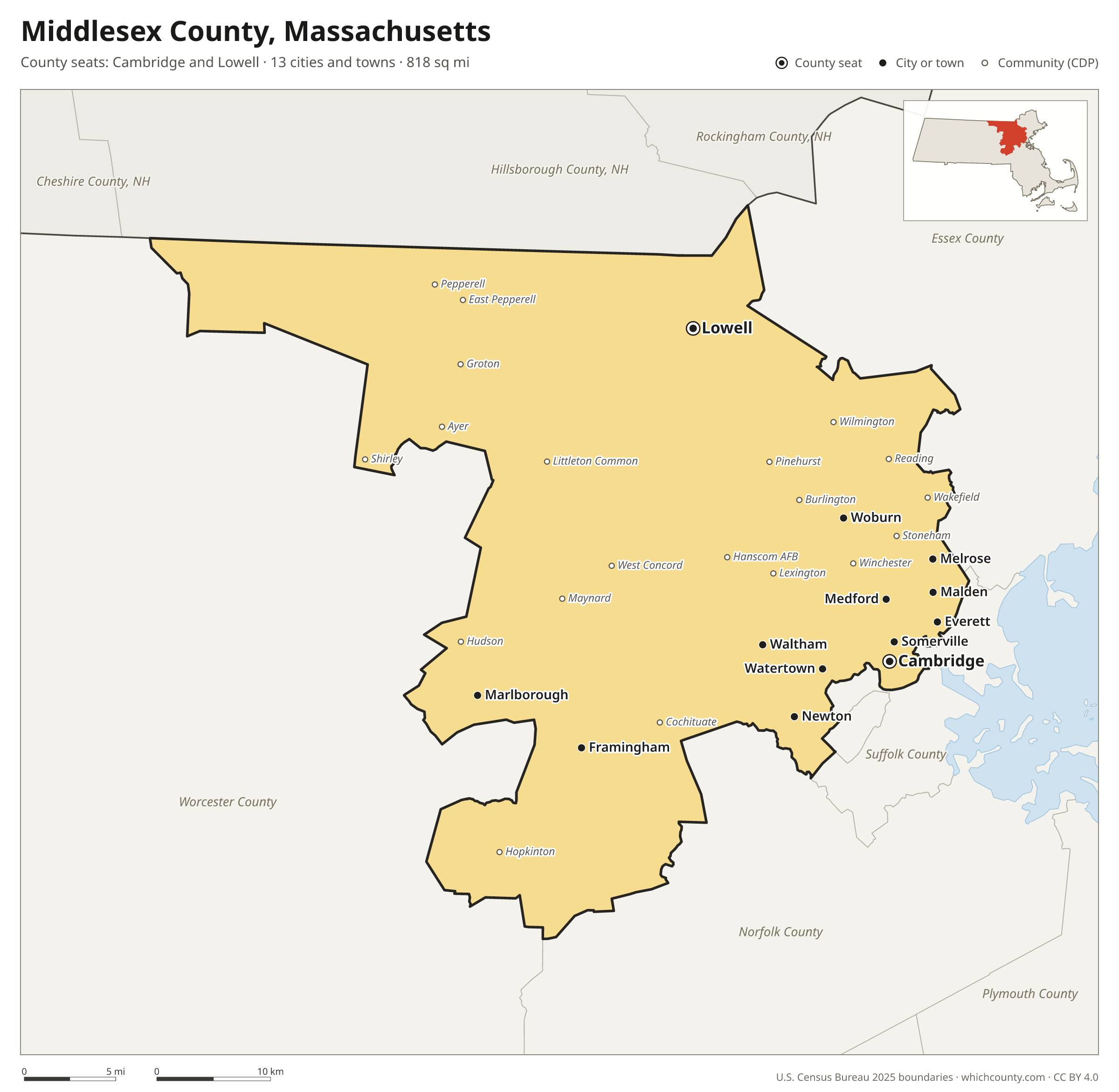
Middlesex County is the most populous of Massachusetts's 14 counties, with 1,669,979 people (2025 estimate). It has 2 county seats: Cambridge and Lowell. The map shows its 13 cities and towns and the 5 neighboring counties.

Middlesex County facts
- County seats
- Cambridge, Lowell
- Population (2025 estimate)
- 1,669,979 +2.3% since 2020
- Land area
- 818 sq mi 3rd largest of 14
- Water area
- 29 sq mi
- Population density
- 2,042 per sq mi
- Established
- 1643
- Same name
- One of 3 Middlesex Counties in the US
- Named after
- Middlesex historic county of England
- Largest city
- Cambridge 122,588
- Median household income
- $130,847
- Cities and towns
- 13 plus 24 CDPs
- ZIP codes
- 83
- Time zone
- Eastern
- FIPS code
- 25017
Cities and towns in Middlesex County
Middlesex County has 13 incorporated cities, towns and villages. Populations count the people living inside Middlesex County; cities that cross a county line also list the other counties.
| Name | Type | Population 2025 | Also in |
|---|---|---|---|
| Cambridge (county seat) | City | 122,588 | |
| Lowell (county seat) | City | 119,971 | |
| Newton | City | 90,741 | |
| Somerville | City | 84,211 | |
| Framingham | City | 73,021 | |
| Malden | City | 66,370 | |
| Waltham | City | 65,037 | |
| Medford | City | 59,834 | |
| Everett | City | 53,572 | |
| Woburn | City | 43,962 | |
| Marlborough | City | 42,772 | |
| Watertown | City | 35,710 | |
| Melrose | City | 29,597 |
Unincorporated communities (CDPs)
Census-designated places are communities without their own city government; the county provides their services.
| Community | Population | Also in |
|---|---|---|
| Arlington | 46,350 | |
| Lexington | 34,295 | |
| Wakefield | 27,793 | |
| Belmont | 27,175 | |
| Burlington | 26,274 | |
| Reading | 25,612 | |
| Winchester | 23,406 | |
| Stoneham | 23,355 | |
| Wilmington | 23,336 | |
| Hudson | 15,719 | |
| Maynard | 10,712 | |
| Pinehurst | 6,845 | |
| Cochituate | 6,471 | |
| West Concord | 5,876 | |
| Hopkinton | 3,426 | |
| Littleton Common | 3,289 | |
| Ayer | 3,098 | |
| Hanscom AFB | 2,110 | |
| Pepperell | 1,971 | |
| East Pepperell | 1,949 | |
| Groton | 1,232 | |
| Shirley | 1,146 | |
| Townsend | 987 | |
| Devens | 283 | Worcester County |
ZIP codes in Middlesex County
83 ZIP codes reach into Middlesex County. ZIP codes ignore county lines, so some also cover a neighboring county.
- 01431
- 01432
- 01434 also Worcester County
- 01450
- 01460
- 01463
- 01464
- 01469
- 01474
- 01701
- 01702
- 01718
- 01719
- 01720
- 01721
- 01730
- 01731
- 01741
- 01742
- 01746
- 01748
- 01749
- 01752
- 01754
- 01760
- 01770
- 01773
- 01775
- 01776
- 01778
- 01801
- 01803
- 01821
- 01824
- 01826 also Essex County
- 01827
- 01850
- 01851
- 01852
- 01854
- 01862
- 01863
- 01864
- 01867
- 01876 also Essex County
- 01879
- 01880
- 01886
- 01887
- 01890
- 02138
- 02139
- 02140
- 02141
- 02142
- 02143
- 02144
- 02145
- 02148
- 02149 also Suffolk County
- 02155
- 02176
- 02180
- 02420
- 02421
- 02451
- 02452
- 02453
- 02458
- 02459
- 02460
- 02461
- 02462
- 02464
- 02465
- 02466
- 02467 also Norfolk and Suffolk counties
- 02468
- 02472
- 02474
- 02476
- 02478
- 02493
Population of Middlesex County, 2020–2025
Middlesex County grew by 38,067 people (+2.3%) between April 2020 and July 2025: 18,568 more births than deaths and a net gain of 21,032 people from migration.
| Year (July 1) | Population |
|---|---|
| 2020 | 1,624,461 |
| 2021 | 1,614,929 |
| 2022 | 1,630,890 |
| 2023 | 1,644,193 |
| 2024 | 1,663,929 |
| 2025 | 1,669,979 |
Neighboring counties
- Worcester County southwest · 888,502 people
- Essex County east · 826,653 people
- Hillsborough County, New Hampshire northwest · 433,415 people
- Norfolk County southeast · 739,749 people
- Suffolk County southeast · 791,891 people
Printable Middlesex County map
The PDF is a vector file with real text: it prints sharp on Letter paper and you can search it for a town. The PNG is 2400 pixels wide for slides and documents. Both are free to use with a credit to WhichCounty.
- PDF (Letter) (183 KB)
- PNG (2400 px) (145 KB)
Paste this code to embed the map on your site:
Sources
- Boundaries: U.S. Census Bureau, 2025 Cartographic Boundary Files (1:500,000).
- Population: Census Bureau county and city estimates, Vintage 2025. CDP populations: American Community Survey 2020–2024.
- Places and ZIP codes: Census Bureau 2026 Gazetteer and 2020 ZIP Code Tabulation Area relationship files.
- County seat, founding year and name origin: Wikidata (CC0), checked against state sources.
Back to the Massachusetts county map with all 14 counties. Found an error? Tell us.