Nassau County, New York
County seat: Mineola · Population 1.4 million (2025) · 285 sq mi
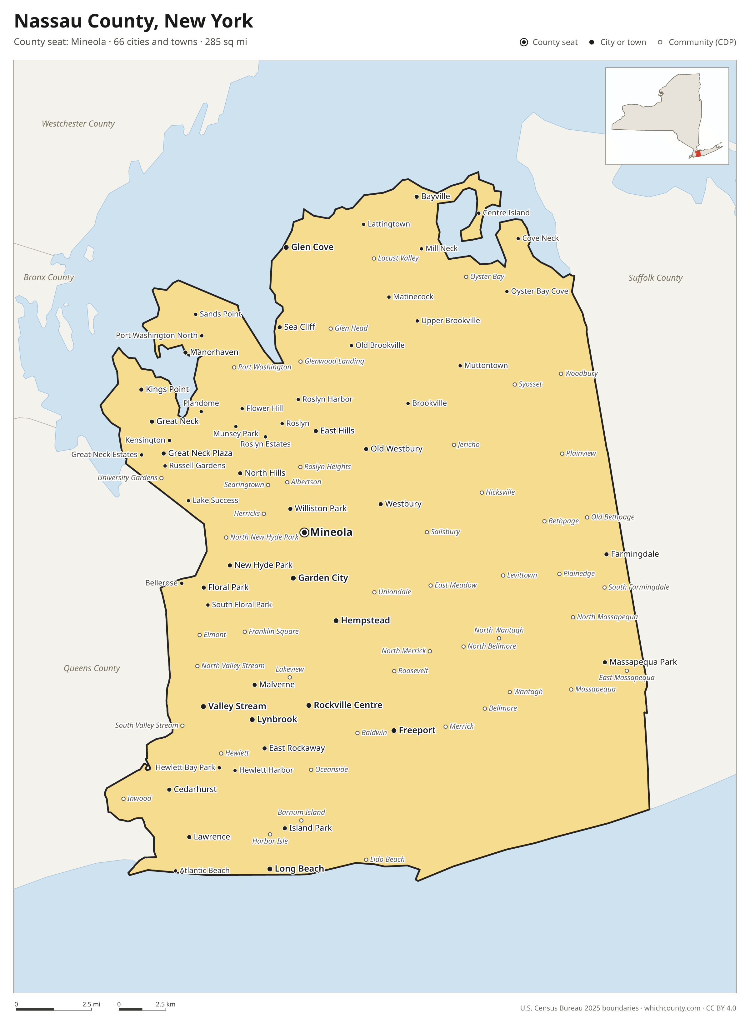
Nassau County is the 6th most populous of New York's 62 counties, with 1,398,939 people (2025 estimate). Its county seat is Mineola. The map shows its 66 cities and towns and the 5 neighboring counties.

Nassau County facts
- County seat
- Mineola
- Population (2025 estimate)
- 1,398,939 +0.2% since 2020
- Land area
- 285 sq mi 54th largest of 62
- Water area
- 169 sq mi
- Population density
- 4,916 per sq mi
- Established
- 1899
- Named after
- William III of England King of England, Scotland, and Ireland from 1689 to 1702 (1650-1702)
- Largest city
- Hempstead 795,734
- Median household income
- $146,202
- Cities and towns
- 66 plus 67 CDPs
- ZIP codes
- 70
- Time zone
- Eastern
- FIPS code
- 36059
Cities and towns in Nassau County
Nassau County has 66 incorporated cities, towns and villages. Populations count the people living inside Nassau County; cities that cross a county line also list the other counties.
| Name | Type | Population 2025 | Also in |
|---|---|---|---|
| Hempstead | Village | 59,819 | |
| Freeport | Village | 44,174 | |
| Valley Stream | Village | 40,379 | |
| Long Beach | City | 34,918 | |
| Glen Cove | City | 28,190 | |
| Rockville Centre | Village | 25,770 | |
| Garden City | Village | 23,043 | |
| Mineola (county seat) | Village | 21,376 | |
| Lynbrook | Village | 20,855 | |
| Massapequa Park | Village | 16,997 | |
| Floral Park | Village | 16,105 | |
| Westbury | Village | 15,981 | |
| Great Neck | Village | 11,141 | |
| New Hyde Park | Village | 10,226 | |
| East Rockaway | Village | 10,096 | |
| Farmingdale | Village | 8,584 | |
| Malverne | Village | 8,476 | |
| Great Neck Plaza | Village | 7,889 | |
| Williston Park | Village | 7,524 | |
| Cedarhurst | Village | 7,334 | |
| East Hills | Village | 7,328 | |
| Manorhaven | Village | 7,135 | |
| Lawrence | Village | 6,847 | |
| Bayville | Village | 6,780 | |
| Kings Point | Village | 5,710 | |
| North Hills | Village | 5,481 | |
| Old Westbury | Village | 5,071 | |
| Island Park | Village | 5,069 | |
| Sea Cliff | Village | 5,031 | |
| Flower Hill | Village | 4,860 | |
| Muttontown | Village | 3,568 | |
| Port Washington North | Village | 3,154 | |
| Great Neck Estates | Village | 3,139 | |
| Brookville | Village | 3,037 | |
| Roslyn | Village | 3,025 | |
| Lake Success | Village | 2,849 | |
| Munsey Park | Village | 2,787 | |
| Thomaston | Village | 2,776 | |
| Sands Point | Village | 2,764 | |
| East Williston | Village | 2,616 | |
| Oyster Bay Cove | Village | 2,288 | |
| Old Brookville | Village | 2,098 | |
| Laurel Hollow | Village | 1,949 | |
| Stewart Manor | Village | 1,925 | |
| Lattingtown | Village | 1,881 | |
| Upper Brookville | Village | 1,778 | |
| South Floral Park | Village | 1,773 | |
| Atlantic Beach | Village | 1,723 | |
| Plandome | Village | 1,482 | |
| Roslyn Estates | Village | 1,333 | |
| Hewlett Harbor | Village | 1,332 | |
| Kensington | Village | 1,278 | |
| Bellerose | Village | 1,169 | |
| Roslyn Harbor | Village | 1,113 | |
| Plandome Heights | Village | 1,019 | |
| Baxter Estates | Village | 1,014 | |
| Mill Neck | Village | 1,010 | |
| Saddle Rock | Village | 1,008 | |
| Russell Gardens | Village | 900 | |
| Woodsburgh | Village | 885 | |
| Matinecock | Village | 854 | |
| Plandome Manor | Village | 823 | |
| Hewlett Neck | Village | 574 | |
| Hewlett Bay Park | Village | 480 | |
| Centre Island | Village | 394 | |
| Cove Neck | Village | 293 |
Unincorporated communities (CDPs)
Census-designated places are communities without their own city government; the county provides their services.
| Community | Population | Also in |
|---|---|---|
| Levittown | 51,904 | |
| Hicksville | 43,780 | |
| East Meadow | 36,821 | |
| Elmont | 36,518 | |
| Baldwin | 34,994 | |
| Uniondale | 33,148 | |
| Oceanside | 31,639 | |
| Franklin Square | 30,897 | |
| Plainview | 25,982 | |
| Merrick | 21,744 | |
| Massapequa | 21,389 | |
| North Bellmore | 20,689 | |
| West Hempstead | 20,648 | |
| East Massapequa | 20,377 | |
| Roosevelt | 18,885 | |
| Syosset | 18,433 | |
| Wantagh | 18,365 | |
| Woodmere | 18,061 | |
| Port Washington | 18,004 | |
| North Massapequa | 17,877 | |
| North Valley Stream | 17,825 | |
| Bethpage | 17,123 | |
| Bellmore | 15,954 | |
| Seaford | 15,549 | |
| South Farmingdale | 14,676 | |
| New Cassel | 14,551 | |
| North New Hyde Park | 14,159 | |
| Jericho | 13,759 | |
| Salisbury | 12,412 | |
| North Merrick | 12,366 | |
| Inwood | 12,235 | |
| North Wantagh | 11,940 | |
| Woodbury | 9,348 | |
| Plainedge | 8,624 | |
| Garden City Park | 7,914 | |
| Manhasset | 7,716 | |
| Hewlett | 7,570 | |
| Oyster Bay | 7,308 | |
| Roslyn Heights | 6,975 | |
| Old Bethpage | 6,546 | |
| South Valley Stream | 6,512 | |
| Lakeview | 5,825 | |
| Carle Place | 5,188 | |
| Albertson | 4,891 | |
| Searingtown | 4,720 | |
| Glen Head | 4,653 | |
| Locust Valley | 4,153 | |
| University Gardens | 4,110 | |
| Garden City South | 4,075 | |
| Herricks | 3,907 | |
| Glenwood Landing | 3,896 | |
| Manhasset Hills | 3,692 | |
| South Hempstead | 3,108 | |
| East Norwich | 2,697 | |
| Lido Beach | 2,495 | |
| Barnum Island | 2,302 | |
| Bellerose Terrace | 2,006 | |
| East Atlantic Beach | 1,825 | |
| Bay Park | 1,510 | |
| Great Neck Gardens | 1,492 | |
| Harbor Isle | 1,176 | |
| Greenvale | 1,113 | |
| Point Lookout | 945 | |
| North Lynbrook | 922 | |
| Malverne Park Oaks | 635 | |
| Saddle Rock Estates | 485 | |
| Harbor Hills | 458 |
ZIP codes in Nassau County
70 ZIP codes reach into Nassau County. ZIP codes ignore county lines, so some also cover a neighboring county.
- 11001 also Queens County
- 11003
- 11010
- 11020
- 11021
- 11023
- 11024
- 11030
- 11040 also Queens County
- 11042
- 11050
- 11096
- 11501
- 11507
- 11509
- 11510
- 11514
- 11516
- 11518
- 11520
- 11530
- 11542
- 11545
- 11547
- 11548
- 11549
- 11550
- 11552
- 11553
- 11554
- 11556
- 11557
- 11558
- 11559
- 11560
- 11561
- 11563
- 11565
- 11566
- 11568
- 11569
- 11570
- 11572
- 11575
- 11576
- 11577
- 11579
- 11580
- 11581
- 11590
- 11596
- 11598
- 11709
- 11710
- 11714
- 11732
- 11735 also Suffolk County
- 11753
- 11756
- 11758 also Suffolk County
- 11762
- 11765
- 11771
- 11783
- 11791
- 11793
- 11797
- 11801
- 11803
- 11804
Population of Nassau County, 2020–2025
Nassau County grew by 3,163 people (+0.2%) between April 2020 and July 2025: 9,816 more births than deaths and a net loss of 7,776 people from migration.
| Year (July 1) | Population |
|---|---|
| 2020 | 1,390,952 |
| 2021 | 1,391,787 |
| 2022 | 1,388,346 |
| 2023 | 1,388,940 |
| 2024 | 1,397,783 |
| 2025 | 1,398,939 |
Neighboring counties
- Suffolk County east · 1,546,090 people
- Queens County west · 2,358,182 people
- Western Connecticut Planning Region, Connecticut north · 640,482 people
- Westchester County north · 1,015,743 people
- Bronx County northwest · 1,406,332 people
Printable Nassau County map
The PDF is a vector file with real text: it prints sharp on Letter paper and you can search it for a town. The PNG is 2400 pixels wide for slides and documents. Both are free to use with a credit to WhichCounty.
- PDF (Letter) (385 KB)
- PNG (2400 px) (251 KB)
Paste this code to embed the map on your site:
Sources
- Boundaries: U.S. Census Bureau, 2025 Cartographic Boundary Files (1:500,000).
- Population: Census Bureau county and city estimates, Vintage 2025. CDP populations: American Community Survey 2020–2024.
- Places and ZIP codes: Census Bureau 2026 Gazetteer and 2020 ZIP Code Tabulation Area relationship files.
- County seat, founding year and name origin: Wikidata (CC0), checked against state sources.
Back to the New York county map with all 62 counties. Found an error? Tell us.