Suffolk County, New York
County seat: Riverhead · Population 1.5 million (2025) · 911 sq mi
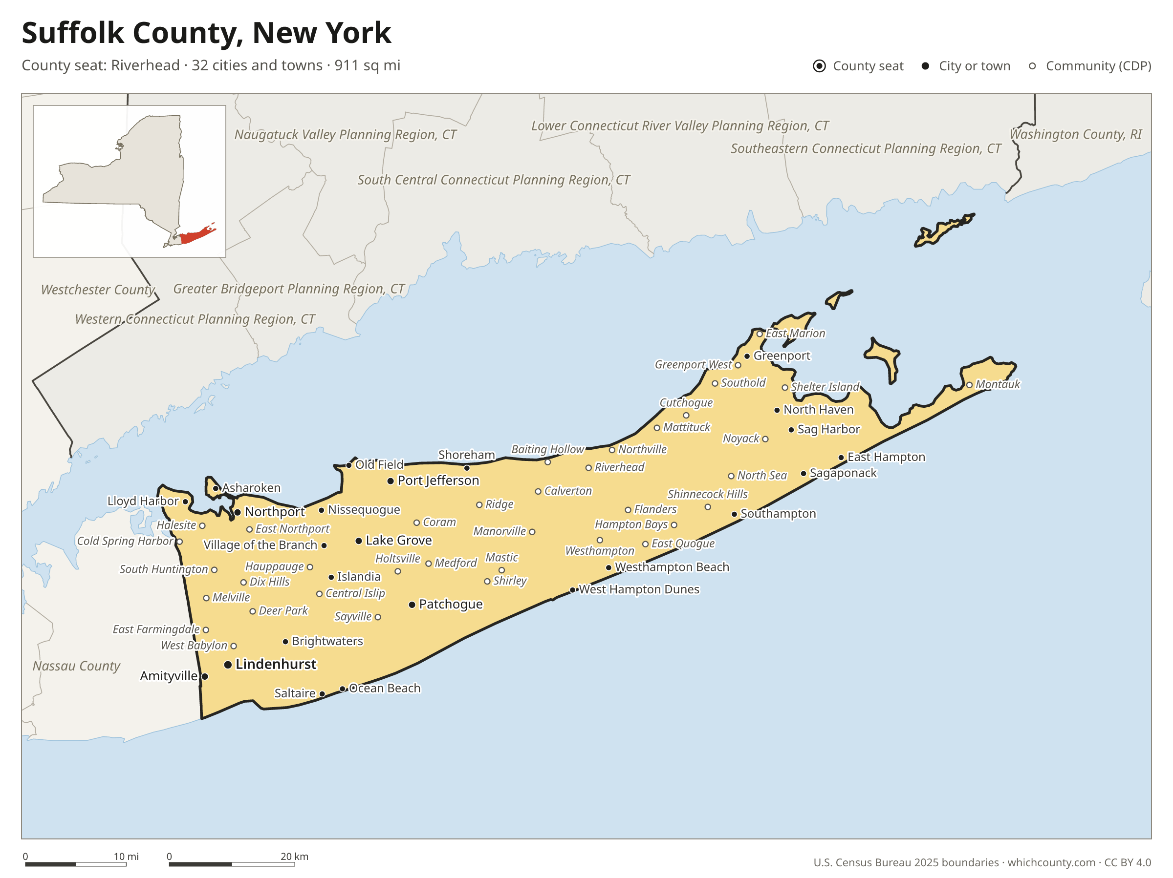
Suffolk County is the 4th most populous of New York's 62 counties, with 1,546,090 people (2025 estimate). Its county seat is Riverhead. The map shows its 32 cities and towns and the 7 neighboring counties.

Suffolk County facts
- County seat
- Riverhead
- Population (2025 estimate)
- 1,546,090 +1.3% since 2020
- Land area
- 911 sq mi 20th largest of 62
- Water area
- 1,462 sq mi
- Population density
- 1,697 per sq mi
- Established
- 1683
- Named after
- Suffolk county of England
- Largest city
- Brookhaven 496,410
- Median household income
- $130,686
- Cities and towns
- 32 plus 125 CDPs
- ZIP codes
- 109
- Time zone
- Eastern
- FIPS code
- 36103
Cities and towns in Suffolk County
Suffolk County has 32 incorporated cities, towns and villages. Populations count the people living inside Suffolk County; cities that cross a county line also list the other counties.
| Name | Type | Population 2025 | Also in |
|---|---|---|---|
| Lindenhurst | Village | 27,258 | |
| Patchogue | Village | 12,486 | |
| Babylon | Village | 12,281 | |
| Lake Grove | Village | 11,168 | |
| Amityville | Village | 9,799 | |
| Port Jefferson | Village | 8,306 | |
| Northport | Village | 7,336 | |
| Southampton | Village | 4,730 | |
| Islandia | Village | 3,733 | |
| Lloyd Harbor | Village | 3,587 | |
| Brightwaters | Village | 3,208 | |
| Sag Harbor | Village | 2,841 | |
| Greenport | Village | 2,590 | |
| Westhampton Beach | Village | 2,273 | |
| Bellport | Village | 2,220 | |
| Village of the Branch | Village | 1,764 | |
| Quogue | Village | 1,703 | |
| Nissequogue | Village | 1,638 | |
| East Hampton | Village | 1,552 | |
| Head of the Harbor | Village | 1,481 | |
| Huntington Bay | Village | 1,459 | |
| North Haven | Village | 1,215 | |
| Old Field | Village | 947 | |
| Poquott | Village | 932 | |
| Belle Terre | Village | 796 | |
| Sagaponack | Village | 752 | |
| Asharoken | Village | 624 | |
| Shoreham | Village | 530 | |
| Ocean Beach | Village | 175 | |
| West Hampton Dunes | Village | 120 | |
| Saltaire | Village | 111 | |
| Dering Harbor | Village | 36 |
Unincorporated communities (CDPs)
Census-designated places are communities without their own city government; the county provides their services.
| Community | Population | Also in |
|---|---|---|
| West Babylon | 43,570 | |
| Coram | 39,539 | |
| Central Islip | 38,373 | |
| Commack | 36,558 | |
| Huntington Station | 32,601 | |
| Centereach | 31,839 | |
| Bay Shore | 31,683 | |
| Shirley | 28,375 | |
| Deer Park | 27,990 | |
| West Islip | 26,865 | |
| Holbrook | 26,449 | |
| Medford | 24,796 | |
| Dix Hills | 24,773 | |
| Smithtown | 24,375 | |
| Copiague | 23,424 | |
| East Patchogue | 21,673 | |
| Selden | 21,604 | |
| North Amityville | 21,138 | |
| Hauppauge | 20,793 | |
| North Bay Shore | 20,282 | |
| Huntington | 19,948 | |
| Melville | 19,714 | |
| East Northport | 19,700 | |
| Holtsville | 19,344 | |
| Ronkonkoma | 18,709 | |
| Lake Ronkonkoma | 18,221 | |
| North Babylon | 17,963 | |
| Islip | 17,362 | |
| Mastic Beach | 16,735 | |
| Kings Park | 16,516 | |
| Farmingville | 16,160 | |
| Mastic | 15,708 | |
| Hampton Bays | 15,706 | |
| Sayville | 15,408 | |
| Greenlawn | 15,210 | |
| Riverhead | 14,936 | |
| Manorville | 14,233 | |
| Nesconset | 13,833 | |
| East Islip | 13,573 | |
| Rocky Point | 13,356 | |
| St. James | 13,244 | |
| Stony Brook | 12,868 | |
| Ridge | 12,503 | |
| Elwood | 11,762 | |
| Miller Place | 11,736 | |
| Mount Sinai | 11,093 | |
| North Bellport | 11,087 | |
| Middle Island | 11,027 | |
| North Lindenhurst | 10,952 | |
| Terryville | 10,794 | |
| Fort Salonga | 10,199 | |
| East Setauket | 10,149 | |
| South Huntington | 9,779 | |
| Stony Brook University | 9,530 | |
| Bohemia | 9,181 | |
| Springs | 9,163 | |
| Center Moriches | 9,127 | |
| Bayport | 8,921 | |
| Wading River | 8,359 | |
| Baywood | 8,176 | |
| Port Jefferson Station | 7,676 | |
| East Shoreham | 7,321 | |
| Sound Beach | 7,210 | |
| Oakdale | 7,115 | |
| North Patchogue | 6,984 | |
| Yaphank | 6,934 | |
| Flanders | 6,609 | |
| North Sea | 6,458 | |
| Southold | 6,397 | |
| East Moriches | 6,260 | |
| Centerport | 6,072 | |
| East Hampton North | 6,006 | |
| East Farmingdale | 5,666 | |
| Calverton | 5,618 | |
| East Quogue | 5,406 | |
| West Hills | 5,369 | |
| Northwest Harbor | 5,205 | |
| Islip Terrace | 5,168 | |
| West Sayville | 4,800 | |
| Noyack | 4,782 | |
| Blue Point | 4,735 | |
| Wheatley Heights | 4,729 | |
| Mattituck | 4,606 | |
| Gordon Heights | 4,230 | |
| Montauk | 4,223 | |
| West Bay Shore | 4,208 | |
| Setauket | 4,069 | |
| Riverside | 4,038 | |
| North Great River | 3,909 | |
| Westhampton | 3,900 | |
| Cold Spring Harbor | 3,220 | |
| Brookhaven | 2,858 | |
| Cutchogue | 2,835 | |
| Water Mill | 2,764 | |
| Halesite | 2,661 | |
| Baiting Hollow | 2,614 | |
| Shinnecock Hills | 2,545 | |
| Greenport West | 2,463 | |
| Eastport | 2,414 | |
| Moriches | 2,308 | |
| Shelter Island | 2,125 | |
| Northville | 1,912 | |
| Great River | 1,899 | |
| Aquebogue | 1,869 | |
| Jamesport | 1,593 | |
| Remsenburg-Speonk | 1,564 | |
| Bridgehampton | 1,531 | |
| Laurel | 1,360 | |
| East Marion | 1,331 | |
| Tuckahoe | 1,249 | |
| Shelter Island Heights | 1,230 | |
| Eatons Neck | 1,173 | |
| Orient | 1,121 | |
| Quiogue | 941 | |
| Peconic | 848 | |
| Amagansett | 821 | |
| Wainscott | 612 | |
| Northampton | 499 | |
| Fire Island | 352 | |
| New Suffolk | 298 | |
| Captree | 282 | |
| Gilgo | 148 | |
| Fishers Island | 72 | |
| Napeague | 70 | |
| Oak Beach | 69 |
ZIP codes in Suffolk County
109 ZIP codes reach into Suffolk County. ZIP codes ignore county lines, so some also cover a neighboring county.
- 06390
- 11701
- 11702
- 11703
- 11704
- 11705
- 11706
- 11713
- 11715
- 11716
- 11717
- 11718
- 11719
- 11720
- 11721
- 11722
- 11724
- 11725
- 11726
- 11727
- 11729
- 11730
- 11731
- 11733
- 11735 also Nassau County
- 11738
- 11739
- 11740
- 11741
- 11742
- 11743
- 11746
- 11747
- 11749
- 11751
- 11752
- 11754
- 11755
- 11757
- 11758 also Nassau County
- 11763
- 11764
- 11766
- 11767
- 11768
- 11769
- 11770
- 11772
- 11776
- 11777
- 11778
- 11779
- 11780
- 11782
- 11784
- 11786
- 11787
- 11788
- 11789
- 11790
- 11792
- 11794
- 11795
- 11796
- 11798
- 11901
- 11930
- 11931
- 11932
- 11933
- 11934
- 11935
- 11937
- 11939
- 11940
- 11941
- 11942
- 11944
- 11946
- 11947
- 11948
- 11949
- 11950
- 11951
- 11952
- 11953
- 11954
- 11955
- 11956
- 11957
- 11958
- 11959
- 11960
- 11961
- 11962
- 11963
- 11964
- 11965
- 11967
- 11968
- 11970
- 11971
- 11972
- 11973
- 11975
- 11976
- 11977
- 11978
- 11980
Population of Suffolk County, 2020–2025
Suffolk County grew by 20,170 people (+1.3%) between April 2020 and July 2025: 9,244 more births than deaths and a net gain of 10,031 people from migration.
| Year (July 1) | Population |
|---|---|
| 2020 | 1,521,964 |
| 2021 | 1,533,742 |
| 2022 | 1,531,736 |
| 2023 | 1,533,173 |
| 2024 | 1,543,330 |
| 2025 | 1,546,090 |
Neighboring counties
- Nassau County west · 1,398,939 people
- South Central Connecticut Planning Region, Connecticut north · 578,741 people
- Southeastern Connecticut Planning Region, Connecticut northeast · 284,015 people
- Greater Bridgeport Planning Region, Connecticut northwest · 337,697 people
- Lower Connecticut River Valley Planning Region, Connecticut north · 177,311 people
- Washington County, Rhode Island northeast · 129,795 people
- Western Connecticut Planning Region, Connecticut northwest · 640,482 people
Printable Suffolk County map
The PDF is a vector file with real text: it prints sharp on Letter paper and you can search it for a town. The PNG is 2400 pixels wide for slides and documents. Both are free to use with a credit to WhichCounty.
- PDF (Letter) (338 KB)
- PNG (2400 px) (194 KB)
Paste this code to embed the map on your site:
Sources
- Boundaries: U.S. Census Bureau, 2025 Cartographic Boundary Files (1:500,000).
- Population: Census Bureau county and city estimates, Vintage 2025. CDP populations: American Community Survey 2020–2024.
- Places and ZIP codes: Census Bureau 2026 Gazetteer and 2020 ZIP Code Tabulation Area relationship files.
- County seat, founding year and name origin: Wikidata (CC0), checked against state sources.
Back to the New York county map with all 62 counties. Found an error? Tell us.