Delaware County, Pennsylvania
County seat: Media · Population 580,937 (2025) · 184 sq mi
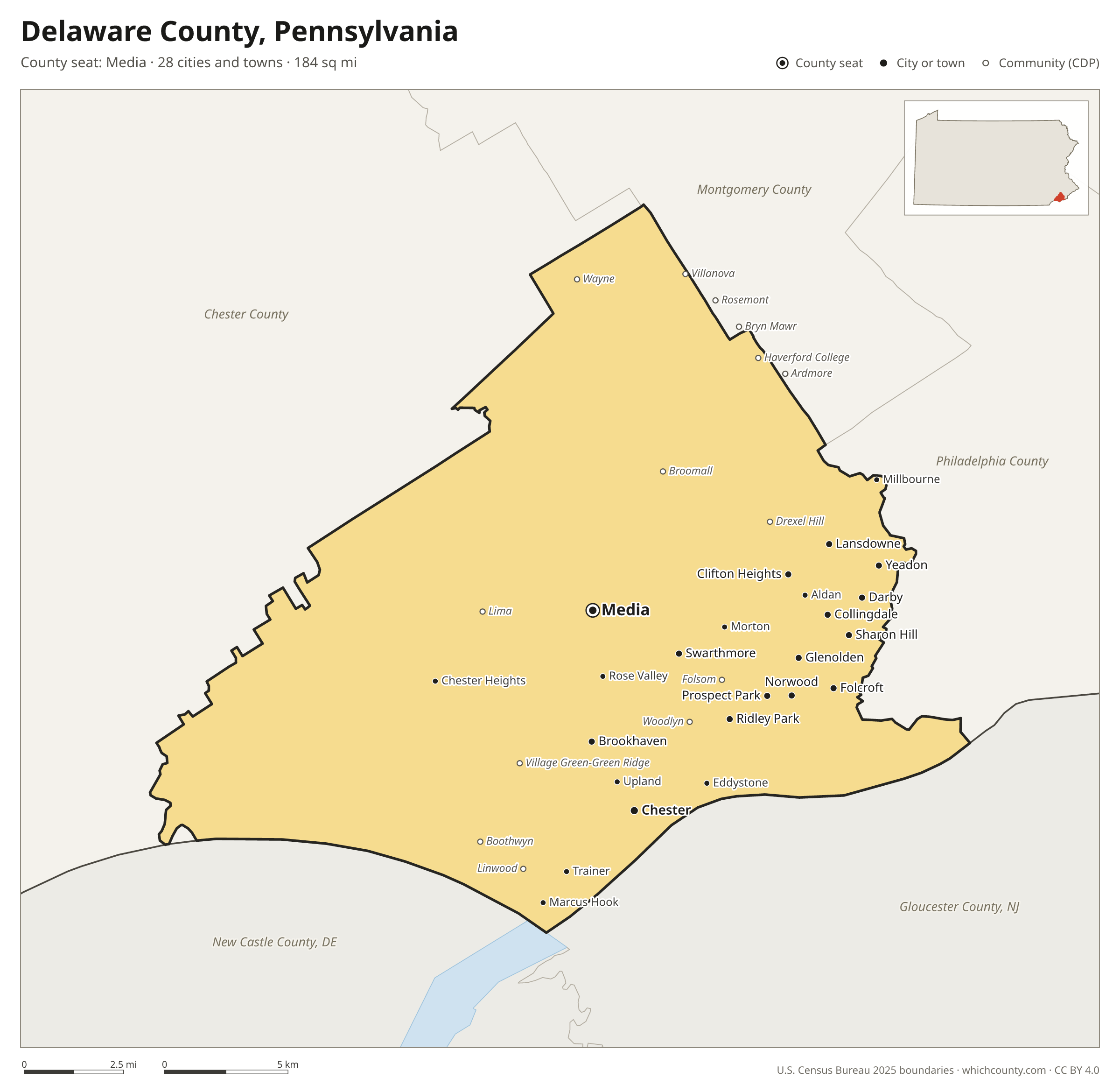
Delaware County is the 5th most populous of Pennsylvania's 67 counties, with 580,937 people (2025 estimate). Its county seat is Media. It is part of the District 6 region, one of the 11 PennDOT engineering districts. The map shows its 28 cities and towns and the 5 neighboring counties.

Delaware County facts
- County seat
- Media
- Population (2025 estimate)
- 580,937 +0.7% since 2020
- Land area
- 184 sq mi 65th largest of 67
- Water area
- 7 sq mi
- Population density
- 3,161 per sq mi
- Established
- 1789
- Same name
- One of 6 Delaware Counties in the US
- Named after
- Delaware River major river on the East coast of the United States of America
- Largest city
- Upper Darby 85,458
- Median household income
- $89,546
- Cities and towns
- 28 plus 18 CDPs
- ZIP codes
- 45
- Time zone
- Eastern
- FIPS code
- 42045
Cities and towns in Delaware County
Delaware County has 28 incorporated cities, towns and villages. Populations count the people living inside Delaware County; cities that cross a county line also list the other counties.
| Name | Type | Population 2025 | Also in |
|---|---|---|---|
| Chester | City | 33,996 | |
| Yeadon | Borough | 12,320 | |
| Lansdowne | Borough | 11,141 | |
| Darby | Borough | 10,666 | |
| Collingdale | Borough | 8,898 | |
| Brookhaven | Borough | 8,362 | |
| Ridley Park | Borough | 7,255 | |
| Glenolden | Borough | 7,217 | |
| Clifton Heights | Borough | 6,835 | |
| Folcroft | Borough | 6,780 | |
| Swarthmore | Borough | 6,561 | |
| Prospect Park | Borough | 6,409 | |
| Sharon Hill | Borough | 5,995 | |
| Norwood | Borough | 5,927 | |
| Media (county seat) | Borough | 5,920 | |
| Aldan | Borough | 4,253 | |
| Chester Heights | Borough | 3,183 | |
| Upland | Borough | 3,049 | |
| Morton | Borough | 2,768 | |
| East Lansdowne | Borough | 2,703 | |
| Colwyn | Borough | 2,465 | |
| Eddystone | Borough | 2,448 | |
| Marcus Hook | Borough | 2,448 | |
| Parkside | Borough | 2,320 | |
| Trainer | Borough | 1,972 | |
| Millbourne | Borough | 1,210 | |
| Rose Valley | Borough | 1,017 | |
| Rutledge | Borough | 779 |
Unincorporated communities (CDPs)
Census-designated places are communities without their own city government; the county provides their services.
| Community | Population | Also in |
|---|---|---|
| Drexel Hill | 30,451 | |
| Broomall | 10,679 | |
| Woodlyn | 9,736 | |
| Village Green-Green Ridge | 9,073 | |
| Folsom | 8,671 | |
| Villanova | 7,329 | Montgomery County |
| Wayne | 6,635 | |
| Ardmore | 5,284 | Montgomery County |
| Boothwyn | 4,774 | |
| Linwood | 3,921 | |
| St. Davids | 3,875 | |
| Lima | 2,812 | |
| Rosemont | 2,132 | Montgomery County |
| Haverford College | 1,554 | Montgomery County |
| Bryn Mawr | 1,534 | Montgomery County |
| Cheyney University | 308 | Chester County |
| Chadds Ford | 44 | Chester County |
| Dilworthtown | 24 | Chester County |
ZIP codes in Delaware County
45 ZIP codes reach into Delaware County. ZIP codes ignore county lines, so some also cover a neighboring county.
- 19003 also Montgomery County
- 19008
- 19010 also Montgomery County
- 19013
- 19014
- 19015
- 19017
- 19018
- 19022
- 19023
- 19026
- 19029
- 19032
- 19033
- 19036
- 19041 also Montgomery County
- 19043
- 19050
- 19052
- 19060
- 19061
- 19063
- 19064
- 19070
- 19073 also Chester County
- 19074
- 19076
- 19078
- 19079
- 19081
- 19082
- 19083 also Montgomery County
- 19085 also Montgomery County
- 19086
- 19087 also Chester and Montgomery counties
- 19094
- 19096 also Montgomery County
- 19113
- 19153 also Philadelphia County
- 19312 also Chester County
- 19317 also Chester County
- 19319 also Chester County
- 19342 also Chester County
- 19373 also Chester County
- 19382 also Chester County
Population of Delaware County, 2020–2025
Delaware County grew by 3,975 people (+0.7%) between April 2020 and July 2025: 2,404 more births than deaths and a net gain of 1,116 people from migration.
| Year (July 1) | Population |
|---|---|
| 2020 | 576,505 |
| 2021 | 577,178 |
| 2022 | 576,666 |
| 2023 | 579,086 |
| 2024 | 581,416 |
| 2025 | 580,937 |
Neighboring counties
- Chester County west · 557,116 people
- Philadelphia County northeast · 1,574,281 people
- Gloucester County, New Jersey southeast · 312,638 people
- New Castle County, Delaware southwest · 588,026 people
- Montgomery County north · 877,643 people
Printable Delaware County map
The PDF is a vector file with real text: it prints sharp on Letter paper and you can search it for a town. The PNG is 2400 pixels wide for slides and documents. Both are free to use with a credit to WhichCounty.
- PDF (Letter) (165 KB)
- PNG (2400 px) (126 KB)
Paste this code to embed the map on your site:
Sources
- Boundaries: U.S. Census Bureau, 2025 Cartographic Boundary Files (1:500,000).
- Population: Census Bureau county and city estimates, Vintage 2025. CDP populations: American Community Survey 2020–2024.
- Places and ZIP codes: Census Bureau 2026 Gazetteer and 2020 ZIP Code Tabulation Area relationship files.
- County seat, founding year and name origin: Wikidata (CC0), checked against state sources.
Back to the Pennsylvania county map with all 67 counties. Found an error? Tell us.