Montgomery County, Pennsylvania
County seat: Norristown · Population 877,643 (2025) · 483 sq mi
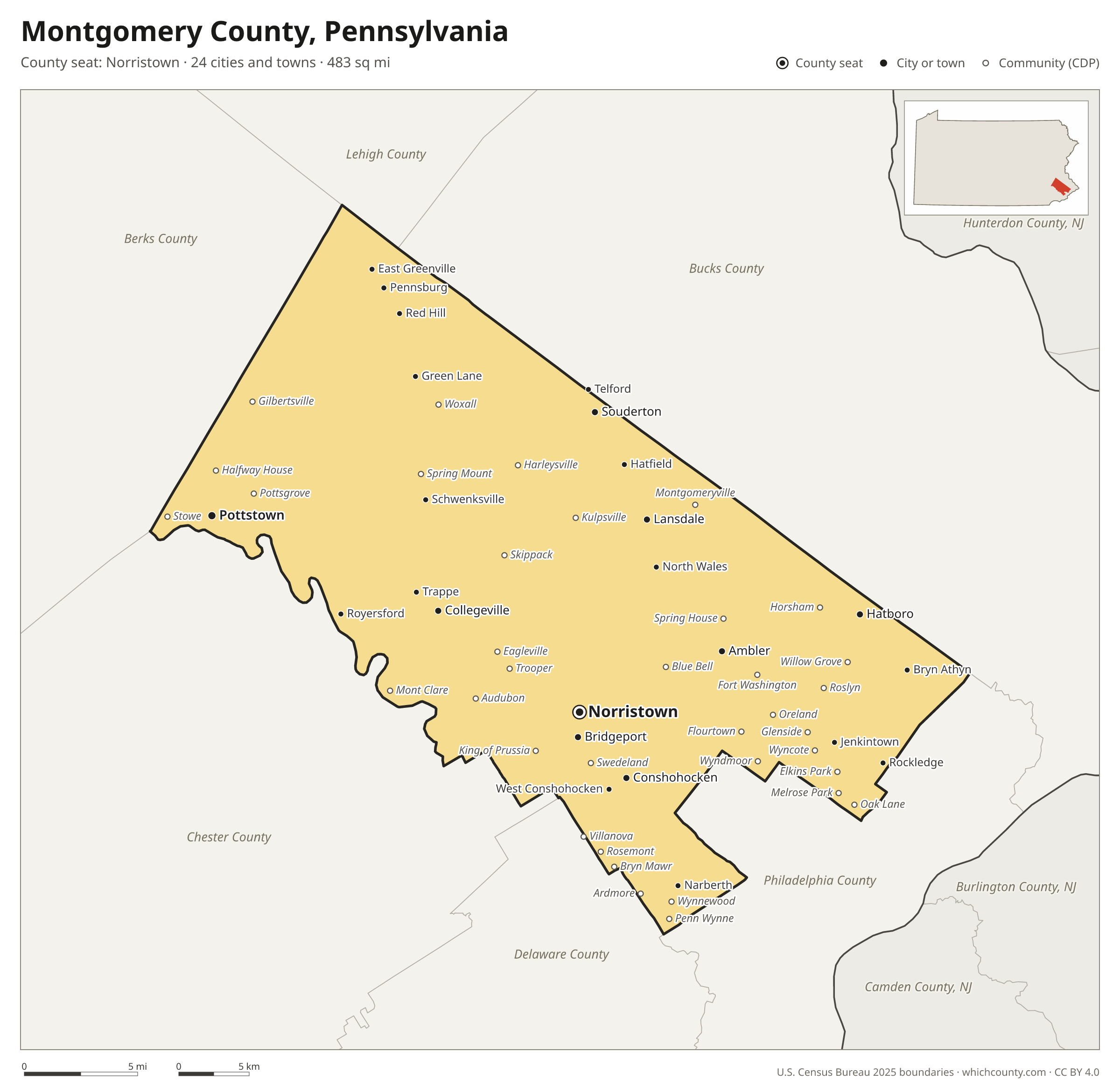
Montgomery County is the 3rd most populous of Pennsylvania's 67 counties, with 877,643 people (2025 estimate). Its county seat is Norristown. It is part of the District 6 region, one of the 11 PennDOT engineering districts. The map shows its 24 cities and towns and the 6 neighboring counties.

Montgomery County facts
- County seat
- Norristown
- Population (2025 estimate)
- 877,643 +2.5% since 2020
- Land area
- 483 sq mi 47th largest of 67
- Water area
- 4 sq mi
- Population density
- 1,817 per sq mi
- Established
- 1784
- Same name
- One of 18 Montgomery Counties in the US
- Named after
- Richard Montgomery, Montgomeryshire
- Largest city
- Lower Merion 64,691
- Median household income
- $113,915
- Cities and towns
- 24 plus 48 CDPs
- ZIP codes
- 71
- Time zone
- Eastern
- FIPS code
- 42091
Cities and towns in Montgomery County
Montgomery County has 24 incorporated cities, towns and villages. Populations count the people living inside Montgomery County; cities that cross a county line also list the other counties.
| Name | Type | Population 2025 | Also in |
|---|---|---|---|
| Norristown (county seat) | Borough | 35,911 | |
| Pottstown | Borough | 23,322 | |
| Lansdale | Borough | 18,986 | |
| Conshohocken | Borough | 9,266 | |
| Hatboro | Borough | 8,593 | |
| Souderton | Borough | 7,288 | |
| Ambler | Borough | 6,840 | |
| Bridgeport | Borough | 5,758 | |
| Collegeville | Borough | 5,287 | |
| Royersford | Borough | 4,888 | |
| Jenkintown | Borough | 4,785 | |
| Narberth | Borough | 4,479 | |
| Trappe | Borough | 4,061 | |
| Pennsburg | Borough | 4,036 | |
| Hatfield | Borough | 3,424 | |
| North Wales | Borough | 3,422 | |
| East Greenville | Borough | 3,154 | |
| Telford | Borough | 2,769 | Bucks County |
| Rockledge | Borough | 2,613 | |
| Red Hill | Borough | 2,508 | |
| West Conshohocken | Borough | 1,498 | |
| Bryn Athyn | Borough | 1,304 | |
| Schwenksville | Borough | 1,265 | |
| Green Lane | Borough | 471 |
Unincorporated communities (CDPs)
Census-designated places are communities without their own city government; the county provides their services.
| Community | Population | Also in |
|---|---|---|
| King of Prussia | 25,857 | |
| Horsham | 16,005 | |
| Willow Grove | 14,131 | |
| Montgomeryville | 13,388 | |
| Roslyn | 10,639 | |
| Bala Cynwyd | 10,227 | |
| Audubon | 9,229 | |
| Harleysville | 9,090 | |
| Sanatoga | 8,949 | |
| Kulpsville | 8,799 | |
| Ardmore | 8,625 | Delaware County |
| Glenside | 7,659 | |
| Plymouth Meeting | 7,502 | |
| Elkins Park | 7,213 | |
| Maple Glen | 6,643 | |
| Blue Bell | 6,424 | |
| Fort Washington | 6,271 | |
| Gilbertsville | 6,165 | |
| Penn Wynne | 6,070 | |
| Oreland | 5,953 | |
| Merion Station | 5,788 | |
| Wyndmoor | 5,633 | |
| Spring House | 5,137 | |
| Flourtown | 4,992 | |
| Eagleville | 4,985 | |
| Trooper | 4,907 | |
| Bryn Mawr | 4,346 | Delaware County |
| Oak Lane | 4,210 | |
| Skippack | 3,937 | |
| Stowe | 3,698 | |
| Halfway House | 3,688 | |
| Pottsgrove | 3,409 | |
| Wyncote | 3,389 | |
| Evansburg | 2,976 | |
| Wynnewood | 2,766 | |
| McKinley | 2,662 | |
| Mont Clare | 2,313 | |
| Spring Mount | 2,288 | |
| Melrose Park | 2,266 | |
| Cheltenham Village | 2,112 | |
| Villanova | 1,857 | Delaware County |
| Swedeland | 1,630 | |
| Woxall | 1,347 | |
| Rosemont | 1,289 | Delaware County |
| Oaks | 943 | |
| Swedesburg | 806 | |
| Arcadia University | 792 | |
| Haverford College | 141 | Delaware County |
ZIP codes in Montgomery County
71 ZIP codes reach into Montgomery County. ZIP codes ignore county lines, so some also cover a neighboring county.
- 18041 also Lehigh, Bucks and Berks counties
- 18054 also Bucks County
- 18070 also Berks County
- 18073 also Bucks County
- 18074
- 18076
- 18914 also Bucks County
- 18915
- 18936
- 18964 also Bucks County
- 18969 also Bucks County
- 19001
- 19002
- 19003 also Delaware County
- 19004
- 19006 also Bucks County
- 19009
- 19010 also Delaware County
- 19012
- 19025
- 19027
- 19031
- 19034
- 19035
- 19038
- 19040 also Bucks County
- 19041 also Delaware County
- 19044
- 19046
- 19066
- 19072
- 19075
- 19083 also Delaware County
- 19085 also Delaware County
- 19087 also Chester and Delaware counties
- 19090
- 19095
- 19096 also Delaware County
- 19118 also Philadelphia County
- 19128 also Philadelphia County
- 19401
- 19403
- 19405
- 19406
- 19422
- 19426
- 19428
- 19435
- 19436
- 19437
- 19438
- 19440 also Bucks County
- 19444
- 19446
- 19453
- 19454 also Bucks County
- 19456
- 19460 also Chester County
- 19462
- 19464 also Berks County
- 19468
- 19472
- 19473
- 19474
- 19477
- 19490
- 19492
- 19504 also Berks County
- 19505 also Berks County
- 19512 also Berks County
- 19525 also Berks County
Population of Montgomery County, 2020–2025
Montgomery County grew by 21,251 people (+2.5%) between April 2020 and July 2025: 757 more births than deaths and a net gain of 20,571 people from migration.
| Year (July 1) | Population |
|---|---|
| 2020 | 856,829 |
| 2021 | 864,286 |
| 2022 | 865,483 |
| 2023 | 870,108 |
| 2024 | 875,160 |
| 2025 | 877,643 |
Neighboring counties
- Chester County southwest · 557,116 people
- Bucks County northeast · 647,828 people
- Philadelphia County southeast · 1,574,281 people
- Berks County northwest · 440,072 people
- Delaware County south · 580,937 people
- Lehigh County northwest · 384,383 people
Printable Montgomery County map
The PDF is a vector file with real text: it prints sharp on Letter paper and you can search it for a town. The PNG is 2400 pixels wide for slides and documents. Both are free to use with a credit to WhichCounty.
- PDF (Letter) (248 KB)
- PNG (2400 px) (170 KB)
Paste this code to embed the map on your site:
Sources
- Boundaries: U.S. Census Bureau, 2025 Cartographic Boundary Files (1:500,000).
- Population: Census Bureau county and city estimates, Vintage 2025. CDP populations: American Community Survey 2020–2024.
- Places and ZIP codes: Census Bureau 2026 Gazetteer and 2020 ZIP Code Tabulation Area relationship files.
- County seat, founding year and name origin: Wikidata (CC0), checked against state sources.
Back to the Pennsylvania county map with all 67 counties. Found an error? Tell us.