Luzerne County, Pennsylvania
County seat: Wilkes-Barre · Population 332,126 (2025) · 890 sq mi
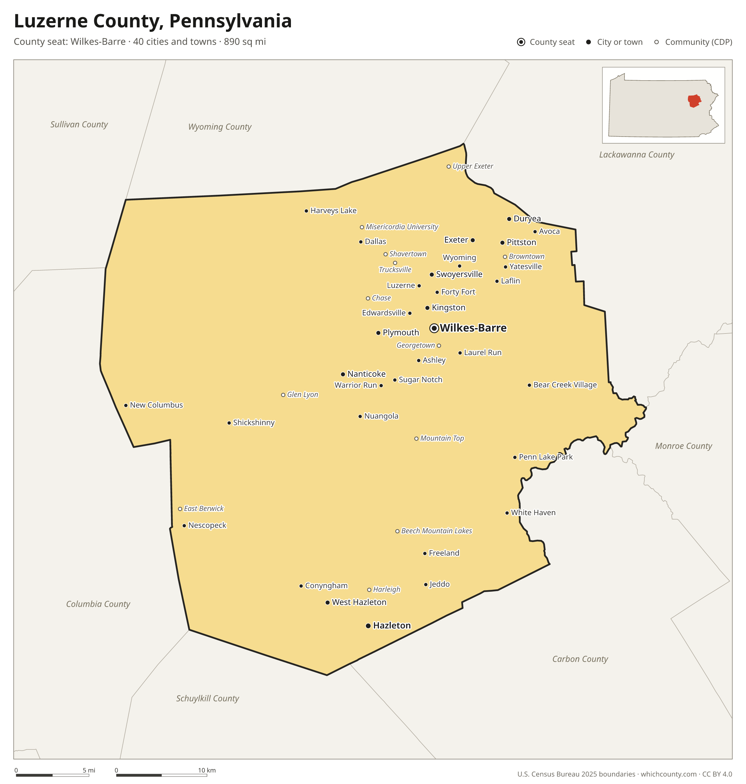
Luzerne County is the 12th most populous of Pennsylvania's 67 counties, with 332,126 people (2025 estimate). Its county seat is Wilkes-Barre. It is part of the District 4 region, one of the 11 PennDOT engineering districts. The map shows its 40 cities and towns and the 7 neighboring counties.

Luzerne County facts
- County seat
- Wilkes-Barre
- Population (2025 estimate)
- 332,126 +2% since 2020
- Land area
- 890 sq mi 14th largest of 67
- Water area
- 16 sq mi
- Population density
- 373 per sq mi
- Established
- 1786
- Named after
- Anne-César, Chevalier de la Luzerne French diplomat (1741–1791)
- Largest city
- Wilkes-Barre 44,523
- Median household income
- $63,691
- Cities and towns
- 40 plus 27 CDPs
- ZIP codes
- 51
- Time zone
- Eastern
- FIPS code
- 42079
Cities and towns in Luzerne County
Luzerne County has 40 incorporated cities, towns and villages. Populations count the people living inside Luzerne County; cities that cross a county line also list the other counties.
| Name | Type | Population 2025 | Also in |
|---|---|---|---|
| Wilkes-Barre (county seat) | City | 44,523 | |
| Hazleton | City | 30,286 | |
| Kingston | Borough | 13,462 | |
| Nanticoke | City | 10,712 | |
| Pittston | City | 7,715 | |
| Plymouth | Borough | 5,801 | |
| Exeter | Borough | 5,587 | |
| West Hazleton | Borough | 5,284 | |
| Duryea | Borough | 5,157 | |
| Swoyersville | Borough | 5,155 | |
| Edwardsville | Borough | 4,927 | |
| West Pittston | Borough | 4,682 | |
| Larksville | Borough | 4,321 | |
| Forty Fort | Borough | 4,280 | |
| Freeland | Borough | 3,811 | |
| Wyoming | Borough | 3,163 | |
| Harveys Lake | Borough | 2,889 | |
| Luzerne | Borough | 2,744 | |
| Dallas | Borough | 2,685 | |
| West Wyoming | Borough | 2,678 | |
| Ashley | Borough | 2,627 | |
| Dupont | Borough | 2,589 | |
| Avoca | Borough | 2,551 | |
| Conyngham | Borough | 1,837 | |
| Nescopeck | Borough | 1,511 | |
| Laflin | Borough | 1,468 | |
| Hughestown | Borough | 1,371 | |
| White Haven | Borough | 1,203 | |
| Sugar Notch | Borough | 989 | |
| Pringle | Borough | 913 | |
| Courtdale | Borough | 707 | |
| Nuangola | Borough | 676 | |
| Yatesville | Borough | 649 | |
| Shickshinny | Borough | 636 | |
| Laurel Run | Borough | 572 | |
| Warrior Run | Borough | 558 | |
| Penn Lake Park | Borough | 383 | |
| Bear Creek Village | Borough | 302 | |
| New Columbus | Borough | 223 | |
| Jeddo | Borough | 102 |
Unincorporated communities (CDPs)
Census-designated places are communities without their own city government; the county provides their services.
| Community | Population | Also in |
|---|---|---|
| Mountain Top | 11,850 | |
| Plains | 4,153 | |
| East Berwick | 2,279 | |
| Shavertown | 2,137 | |
| Beech Mountain Lakes | 2,111 | |
| Trucksville | 2,042 | |
| Glen Lyon | 1,925 | |
| Georgetown | 1,880 | |
| Browntown | 1,671 | |
| Hudson | 1,588 | |
| Inkerman | 1,581 | |
| Harleigh | 1,389 | |
| Chase | 1,037 | |
| Hilldale | 1,012 | |
| Misericordia University | 1,011 | |
| Upper Exeter | 1,004 | |
| Silkworth | 745 | |
| Lattimer | 684 | |
| West Nanticoke | 632 | |
| Sheatown | 614 | |
| Mocanaqua | 593 | |
| Wanamie | 555 | |
| Weston | 495 | |
| Hickory Hills | 480 | |
| Pardeesville | 366 | |
| Pikes Creek | 221 | |
| Nuremberg | 0 | Schuylkill County |
ZIP codes in Luzerne County
51 ZIP codes reach into Luzerne County. ZIP codes ignore county lines, so some also cover a neighboring county.
- 17814 also Columbia, Sullivan and Lycoming counties
- 17815 also Columbia and Montour counties
- 17878 also Columbia County
- 18201 also Carbon County
- 18202 also Schuylkill County
- 18216 also Carbon County
- 18219
- 18221
- 18222
- 18223
- 18224
- 18225
- 18234
- 18239
- 18241 also Schuylkill County
- 18246
- 18249
- 18255 also Carbon County
- 18256
- 18424 also Lackawanna, Wayne and Monroe counties
- 18602
- 18603 also Columbia County
- 18610 also Monroe County
- 18612 also Wyoming County
- 18615 also Wyoming County
- 18617
- 18618 also Wyoming County
- 18621
- 18622
- 18627
- 18634
- 18635 also Columbia County
- 18636 also Wyoming County
- 18640
- 18641 also Lackawanna County
- 18642
- 18643
- 18644
- 18651
- 18655 also Columbia County
- 18656
- 18660
- 18661 also Carbon County
- 18701
- 18702
- 18704
- 18705
- 18706
- 18707
- 18708
- 18709
Population of Luzerne County, 2020–2025
Luzerne County grew by 6,541 people (+2%) between April 2020 and July 2025: 5,898 more deaths than births and a net gain of 12,463 people from migration.
| Year (July 1) | Population |
|---|---|
| 2020 | 325,195 |
| 2021 | 325,987 |
| 2022 | 326,627 |
| 2023 | 328,684 |
| 2024 | 330,898 |
| 2025 | 332,126 |
Neighboring counties
- Carbon County southeast · 65,868 people
- Columbia County west · 66,193 people
- Lackawanna County northeast · 216,502 people
- Wyoming County north · 25,790 people
- Schuylkill County south · 145,085 people
- Monroe County east · 167,179 people
- Sullivan County northwest · 5,856 people
Printable Luzerne County map
The PDF is a vector file with real text: it prints sharp on Letter paper and you can search it for a town. The PNG is 2400 pixels wide for slides and documents. Both are free to use with a credit to WhichCounty.
- PDF (Letter) (191 KB)
- PNG (2400 px) (139 KB)
Paste this code to embed the map on your site:
Sources
- Boundaries: U.S. Census Bureau, 2025 Cartographic Boundary Files (1:500,000).
- Population: Census Bureau county and city estimates, Vintage 2025. CDP populations: American Community Survey 2020–2024.
- Places and ZIP codes: Census Bureau 2026 Gazetteer and 2020 ZIP Code Tabulation Area relationship files.
- County seat, founding year and name origin: Wikidata (CC0), checked against state sources.
Back to the Pennsylvania county map with all 67 counties. Found an error? Tell us.