Schuylkill County, Pennsylvania
County seat: Pottsville · Population 145,085 (2025) · 779 sq mi
Schuylkill County is the 25th most populous of Pennsylvania's 67 counties, with 145,085 people (2025 estimate). Its county seat is Pottsville. It is part of the District 5 region, one of the 11 PennDOT engineering districts. The map shows its 31 cities and towns and the 8 neighboring counties.

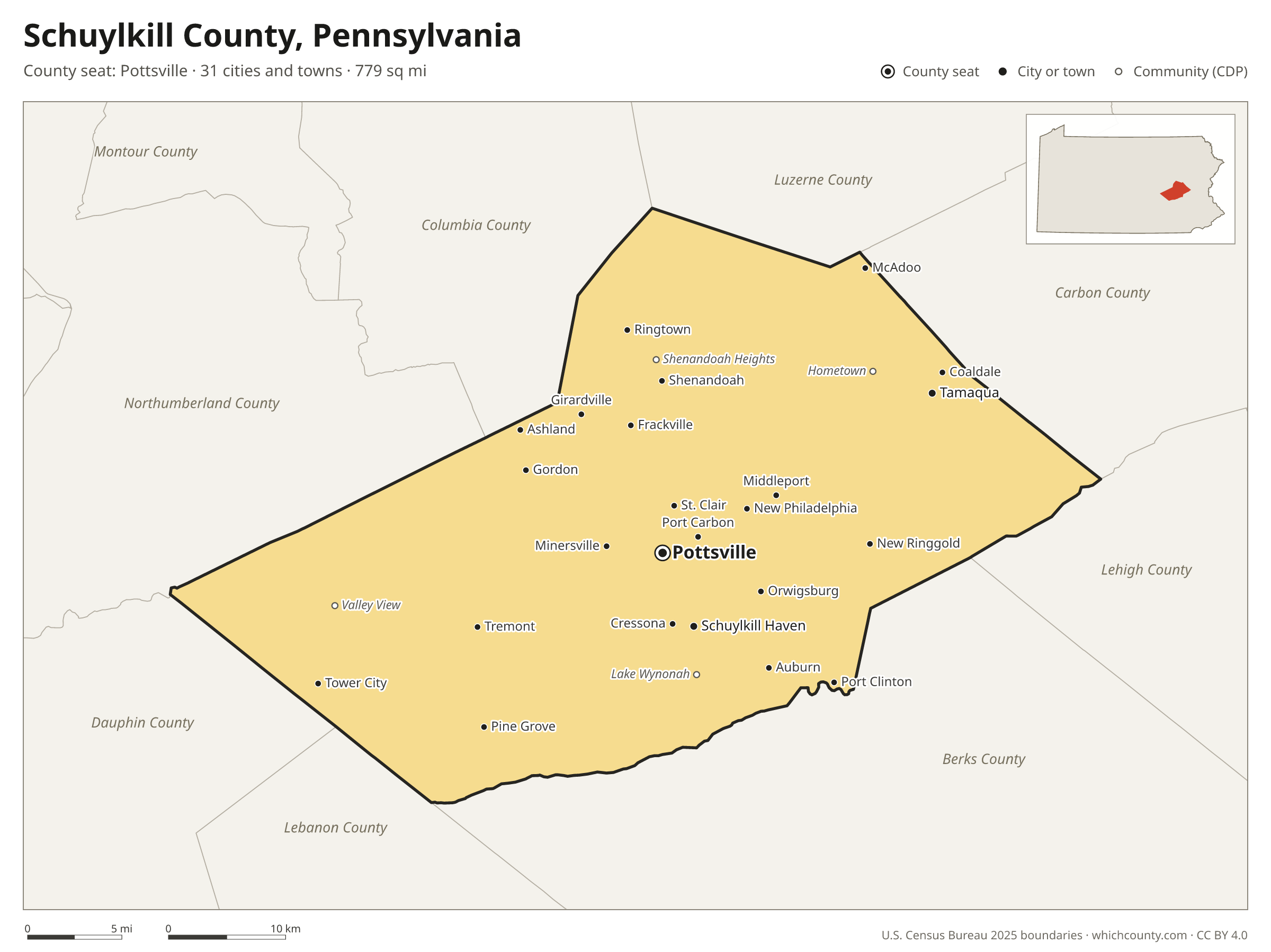
Schuylkill County facts
- County seat
- Pottsville
- Population (2025 estimate)
- 145,085 +1.4% since 2020
- Land area
- 779 sq mi 26th largest of 67
- Water area
- 4 sq mi
- Population density
- 186 per sq mi
- Established
- 1811
- Named after
- Schuylkill River river in eastern Pennsylvania, United States
- Largest city
- Pottsville 13,170
- Median household income
- $68,313
- Cities and towns
- 31 plus 44 CDPs
- ZIP codes
- 59
- Time zone
- Eastern
- FIPS code
- 42107
Cities and towns in Schuylkill County
Schuylkill County has 31 incorporated cities, towns and villages. Populations count the people living inside Schuylkill County; cities that cross a county line also list the other counties.
| Name | Type | Population 2025 | Also in |
|---|---|---|---|
| Pottsville (county seat) | City | 13,170 | |
| Tamaqua | Borough | 6,929 | |
| Schuylkill Haven | Borough | 5,253 | |
| Minersville | Borough | 4,423 | |
| Shenandoah | Borough | 4,122 | |
| Frackville | Borough | 3,893 | |
| Mahanoy City | Borough | 3,539 | |
| Orwigsburg | Borough | 3,003 | |
| St. Clair | Borough | 2,755 | |
| Ashland | Borough | 2,520 | Columbia County |
| McAdoo | Borough | 2,474 | |
| Coaldale | Borough | 2,440 | |
| Pine Grove | Borough | 2,077 | |
| Port Carbon | Borough | 1,806 | |
| Tremont | Borough | 1,696 | |
| Cressona | Borough | 1,622 | |
| Tower City | Borough | 1,434 | |
| Girardville | Borough | 1,325 | |
| New Philadelphia | Borough | 1,062 | |
| Palo Alto | Borough | 983 | |
| Gordon | Borough | 769 | |
| Ringtown | Borough | 721 | |
| Deer Lake | Borough | 693 | |
| Auburn | Borough | 677 | |
| Gilberton | Borough | 590 | |
| Mechanicsville | Borough | 458 | |
| Middleport | Borough | 363 | |
| Port Clinton | Borough | 281 | |
| New Ringgold | Borough | 254 | |
| Landingville | Borough | 145 | |
| Mount Carbon | Borough | 92 |
Unincorporated communities (CDPs)
Census-designated places are communities without their own city government; the county provides their services.
| Community | Population | Also in |
|---|---|---|
| Lake Wynonah | 3,036 | |
| Valley View | 1,487 | |
| Hometown | 1,283 | |
| Shenandoah Heights | 1,262 | |
| Hegins | 1,088 | |
| Friedensburg | 842 | |
| Englewood | 661 | |
| Park Crest | 645 | |
| Sheppton | 588 | |
| Lavelle | 572 | |
| Muir | 572 | |
| Ravine | 537 | |
| Altamont | 526 | |
| Renningers | 511 | |
| Forestville | 483 | |
| Tuscarora | 452 | |
| Kelayres | 413 | |
| Donaldson | 395 | |
| Branchdale | 379 | |
| Oneida | 371 | |
| Reinerton | 358 | |
| Seltzer | 321 | |
| Brockton | 308 | |
| Marlin | 281 | |
| Heckscherville | 279 | |
| Newtown | 275 | |
| Llewellyn | 269 | |
| Buck Run | 252 | |
| Cumbola | 243 | |
| Park Place | 204 | |
| Summit Station | 201 | |
| Orwin | 200 | |
| Brandonville | 199 | |
| New Boston | 192 | |
| Grier City | 167 | |
| Maryd | 164 | |
| Morea | 157 | |
| McKeansburg | 153 | |
| Delano | 148 | |
| Nuremberg | 133 | Luzerne County |
| Klingerstown | 105 | |
| Fountain Springs | 99 | |
| Beurys Lake | 98 | |
| Locustdale | 10 | Columbia County |
ZIP codes in Schuylkill County
59 ZIP codes reach into Schuylkill County. ZIP codes ignore county lines, so some also cover a neighboring county.
- 17901
- 17921 also Columbia County
- 17922
- 17923
- 17925
- 17929
- 17930
- 17931
- 17933
- 17934
- 17935
- 17936
- 17938
- 17941 also Northumberland County
- 17943
- 17944
- 17945 also Columbia County
- 17946
- 17948
- 17949
- 17951
- 17952
- 17953
- 17954
- 17957
- 17959
- 17960
- 17961
- 17963 also Lebanon County
- 17964 also Northumberland County
- 17965
- 17967
- 17968
- 17970
- 17972
- 17974
- 17976
- 17978 also Dauphin County
- 17979
- 17980 also Dauphin County
- 17981
- 17982
- 17983
- 17985 also Columbia County
- 18202 also Luzerne County
- 18211 also Carbon County
- 18214
- 18218
- 18220
- 18231
- 18237 also Carbon County
- 18240 also Carbon County
- 18241 also Luzerne County
- 18242
- 18245
- 18248
- 18250 also Carbon County
- 18252
- 19549
Population of Schuylkill County, 2020–2025
Schuylkill County grew by 2,043 people (+1.4%) between April 2020 and July 2025: 4,222 more deaths than births and a net gain of 6,280 people from migration.
| Year (July 1) | Population |
|---|---|
| 2020 | 142,944 |
| 2021 | 143,148 |
| 2022 | 143,114 |
| 2023 | 143,892 |
| 2024 | 144,409 |
| 2025 | 145,085 |
Neighboring counties
- Berks County southeast · 440,072 people
- Northumberland County west · 89,920 people
- Carbon County northeast · 65,868 people
- Columbia County north · 66,193 people
- Luzerne County north · 332,126 people
- Dauphin County southwest · 293,351 people
- Lehigh County east · 384,383 people
- Lebanon County southwest · 146,380 people
Printable Schuylkill County map
The PDF is a vector file with real text: it prints sharp on Letter paper and you can search it for a town. The PNG is 2400 pixels wide for slides and documents. Both are free to use with a credit to WhichCounty.
- PDF (Letter) (150 KB)
- PNG (2400 px) (111 KB)
Paste this code to embed the map on your site:
Sources
- Boundaries: U.S. Census Bureau, 2025 Cartographic Boundary Files (1:500,000).
- Population: Census Bureau county and city estimates, Vintage 2025. CDP populations: American Community Survey 2020–2024.
- Places and ZIP codes: Census Bureau 2026 Gazetteer and 2020 ZIP Code Tabulation Area relationship files.
- County seat, founding year and name origin: Wikidata (CC0), checked against state sources.
Back to the Pennsylvania county map with all 67 counties. Found an error? Tell us.