Somerset County, Pennsylvania
County seat: Somerset · Population 72,004 (2025) · 1,075 sq mi
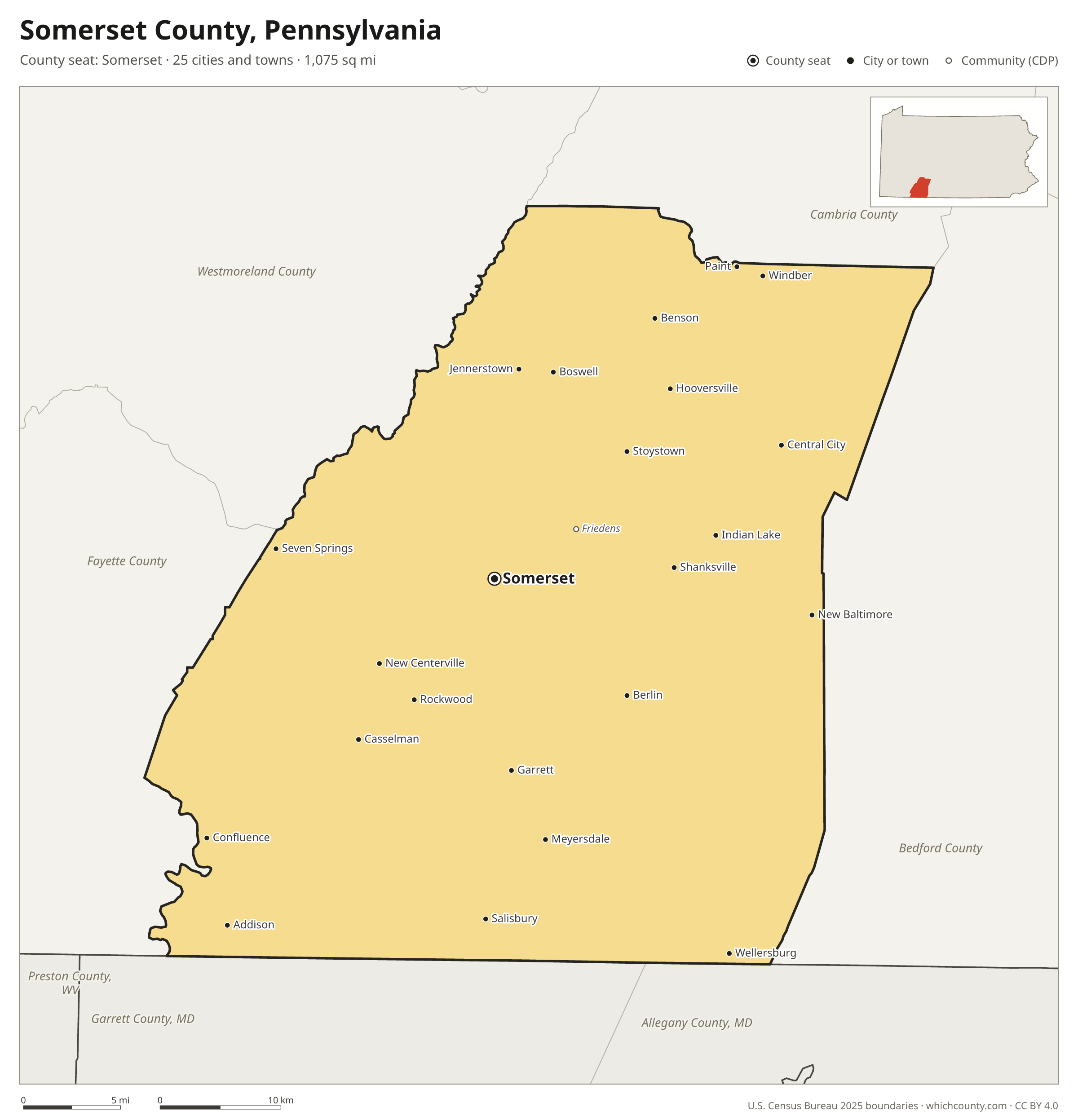
Somerset County is the 37th most populous of Pennsylvania's 67 counties, with 72,004 people (2025 estimate). Its county seat is Somerset. It is part of the District 9 region, one of the 11 PennDOT engineering districts. The map shows its 25 cities and towns and the 6 neighboring counties.

Somerset County facts
- County seat
- Somerset
- Population (2025 estimate)
- 72,004 −2.9% since 2020
- Land area
- 1,075 sq mi 7th largest of 67
- Water area
- 7 sq mi
- Population density
- 67 per sq mi
- Established
- 1795
- Same name
- One of 4 Somerset Counties in the US
- Named after
- Somerset ceremonial county of England (use Q21694741 for administrative non-metropolitan county)
- Largest city
- Somerset 11,645
- Median household income
- $61,446
- Cities and towns
- 25 plus 7 CDPs
- ZIP codes
- 41
- Time zone
- Eastern
- FIPS code
- 42111
Cities and towns in Somerset County
Somerset County has 25 incorporated cities, towns and villages. Populations count the people living inside Somerset County; cities that cross a county line also list the other counties.
| Name | Type | Population 2025 | Also in |
|---|---|---|---|
| Somerset (county seat) | Borough | 5,815 | |
| Windber | Borough | 3,780 | |
| Meyersdale | Borough | 1,986 | |
| Berlin | Borough | 1,956 | |
| Boswell | Borough | 1,197 | |
| Central City | Borough | 954 | |
| Paint | Borough | 875 | |
| Rockwood | Borough | 811 | |
| Confluence | Borough | 705 | |
| Salisbury | Borough | 681 | |
| Jennerstown | Borough | 657 | |
| Hooversville | Borough | 605 | |
| Garrett | Borough | 408 | |
| Indian Lake | Borough | 377 | |
| Stoystown | Borough | 286 | |
| Ursina | Borough | 228 | |
| Addison | Borough | 215 | |
| Wellersburg | Borough | 206 | |
| Shanksville | Borough | 189 | |
| Benson | Borough | 177 | |
| New Baltimore | Borough | 134 | |
| New Centerville | Borough | 121 | |
| Casselman | Borough | 119 | |
| Callimont | Borough | 48 | |
| Seven Springs | Borough | 11 | Fayette County |
Unincorporated communities (CDPs)
Census-designated places are communities without their own city government; the county provides their services.
| Community | Population | Also in |
|---|---|---|
| Friedens | 1,018 | |
| Davidsville | 826 | |
| Jerome | 611 | |
| Cairnbrook | 419 | |
| Acosta | 301 | |
| Gray | 252 | |
| Edie | 158 |
ZIP codes in Somerset County
41 ZIP codes reach into Somerset County. ZIP codes ignore county lines, so some also cover a neighboring county.
- 15411
- 15424 also Fayette County
- 15501 also Westmoreland County
- 15502
- 15510
- 15520
- 15530
- 15531 also Westmoreland County
- 15532
- 15534 also Bedford County
- 15538
- 15540
- 15541
- 15542
- 15544
- 15545 also Bedford County
- 15546
- 15547
- 15551
- 15552
- 15555
- 15557 also Fayette County
- 15558
- 15559 also Bedford County
- 15560
- 15561
- 15562
- 15563
- 15564
- 15565
- 15622 also Fayette and Westmoreland counties
- 15904 also Cambria County
- 15905 also Cambria County
- 15924
- 15926
- 15928
- 15935
- 15936
- 15937
- 15953
- 15963 also Cambria County
Population of Somerset County, 2020–2025
Somerset County shrank by 2,120 people (−2.9%) between April 2020 and July 2025: 2,450 more deaths than births and a net gain of 383 people from migration.
| Year (July 1) | Population |
|---|---|
| 2020 | 73,994 |
| 2021 | 72,973 |
| 2022 | 72,570 |
| 2023 | 72,270 |
| 2024 | 72,209 |
| 2025 | 72,004 |
Neighboring counties
- Bedford County east · 47,480 people
- Fayette County west · 123,021 people
- Westmoreland County northwest · 349,324 people
- Garrett County, Maryland southwest · 28,370 people
- Cambria County northeast · 128,968 people
- Allegany County, Maryland southeast · 66,848 people
Printable Somerset County map
The PDF is a vector file with real text: it prints sharp on Letter paper and you can search it for a town. The PNG is 2400 pixels wide for slides and documents. Both are free to use with a credit to WhichCounty.
- PDF (Letter) (137 KB)
- PNG (2400 px) (107 KB)
Paste this code to embed the map on your site:
Sources
- Boundaries: U.S. Census Bureau, 2025 Cartographic Boundary Files (1:500,000).
- Population: Census Bureau county and city estimates, Vintage 2025. CDP populations: American Community Survey 2020–2024.
- Places and ZIP codes: Census Bureau 2026 Gazetteer and 2020 ZIP Code Tabulation Area relationship files.
- County seat, founding year and name origin: Wikidata (CC0), checked against state sources.
Back to the Pennsylvania county map with all 67 counties. Found an error? Tell us.