Cambria County, Pennsylvania
County seat: Ebensburg · Population 128,968 (2025) · 688 sq mi
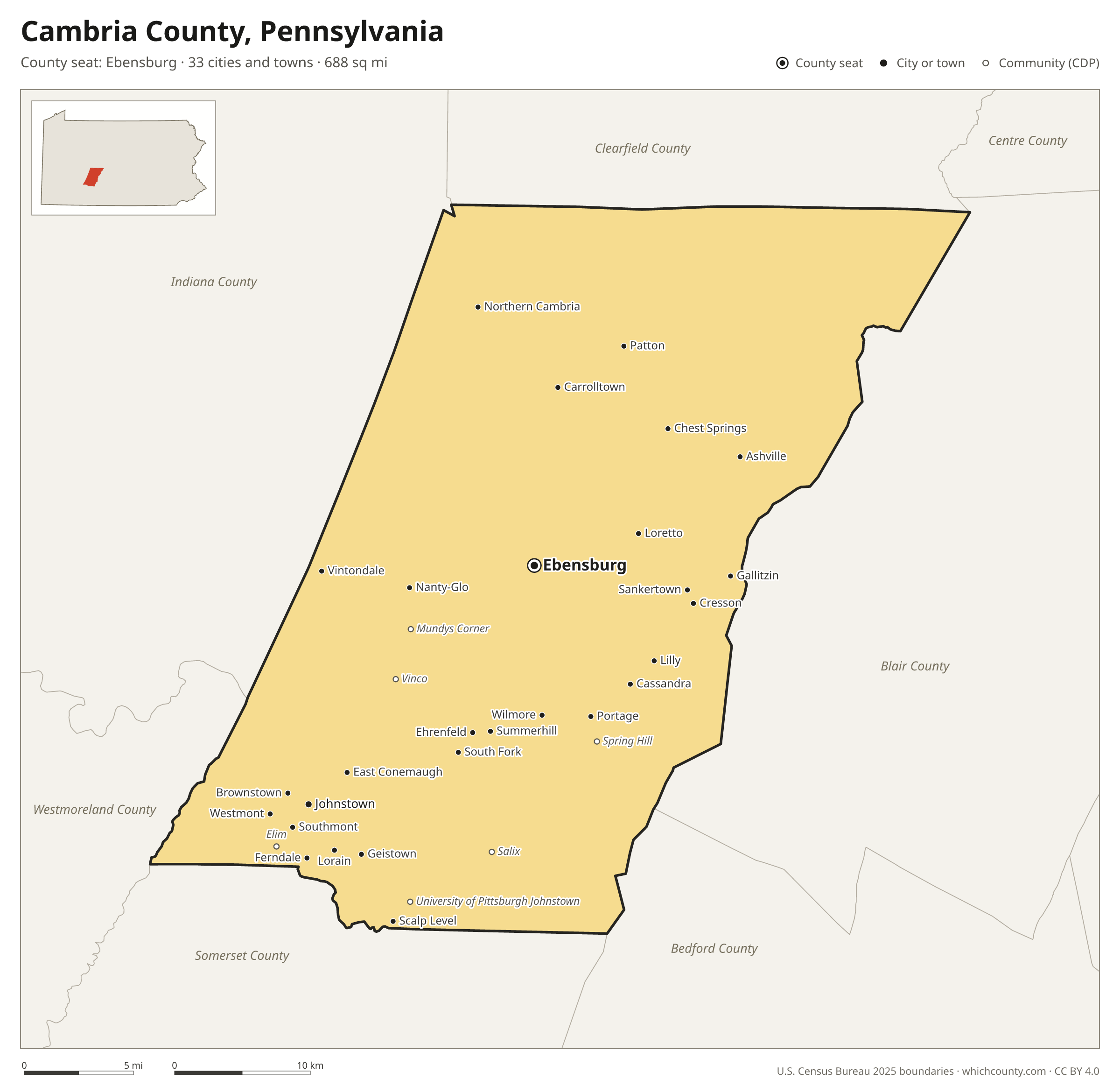
Cambria County is the 26th most populous of Pennsylvania's 67 counties, with 128,968 people (2025 estimate). Its county seat is Ebensburg. It is part of the District 9 region, one of the 11 PennDOT engineering districts. The map shows its 33 cities and towns and the 6 neighboring counties.

Cambria County facts
- County seat
- Ebensburg
- Population (2025 estimate)
- 128,968 −3.4% since 2020
- Land area
- 688 sq mi 31st largest of 67
- Water area
- 5 sq mi
- Population density
- 188 per sq mi
- Established
- 1804
- Named after
- Cambria Latin name of Wales
- Largest city
- Johnstown 17,654
- Median household income
- $58,418
- Cities and towns
- 33 plus 26 CDPs
- ZIP codes
- 52
- Time zone
- Eastern
- FIPS code
- 42021
Cities and towns in Cambria County
Cambria County has 33 incorporated cities, towns and villages. Populations count the people living inside Cambria County; cities that cross a county line also list the other counties.
| Name | Type | Population 2025 | Also in |
|---|---|---|---|
| Johnstown | City | 17,654 | |
| Westmont | Borough | 4,747 | |
| Northern Cambria | Borough | 3,399 | |
| Ebensburg (county seat) | Borough | 3,228 | |
| Nanty-Glo | Borough | 2,413 | |
| Portage | Borough | 2,344 | |
| Geistown | Borough | 2,263 | |
| Southmont | Borough | 1,957 | |
| Patton | Borough | 1,656 | |
| Ferndale | Borough | 1,485 | |
| Cresson | Borough | 1,465 | |
| Gallitzin | Borough | 1,465 | |
| Hastings | Borough | 1,168 | |
| Loretto | Borough | 1,135 | |
| East Conemaugh | Borough | 1,034 | |
| Carrolltown | Borough | 998 | |
| Dale | Borough | 947 | |
| South Fork | Borough | 907 | |
| Lilly | Borough | 842 | |
| Scalp Level | Borough | 716 | |
| Brownstown | Borough | 664 | |
| Sankertown | Borough | 613 | |
| Lorain | Borough | 568 | |
| Summerhill | Borough | 461 | |
| Vintondale | Borough | 399 | |
| Daisytown | Borough | 283 | |
| Franklin | Borough | 263 | |
| Ashville | Borough | 206 | |
| Tunnelhill | Borough | 198 | Blair County |
| Wilmore | Borough | 198 | |
| Ehrenfeld | Borough | 196 | |
| Cassandra | Borough | 153 | |
| Chest Springs | Borough | 133 |
Unincorporated communities (CDPs)
Census-designated places are communities without their own city government; the county provides their services.
| Community | Population | Also in |
|---|---|---|
| Elim | 3,759 | |
| Belmont | 2,618 | |
| Vinco | 1,657 | |
| Oakland | 1,627 | |
| Westwood | 1,613 | |
| Mundys Corner | 1,394 | |
| University of Pittsburgh Johnstown | 1,380 | |
| Salix | 1,115 | |
| Spring Hill | 1,006 | |
| Beaverdale | 852 | |
| Colver | 559 | |
| St. Benedict | 476 | |
| Elmora | 435 | |
| St. Michael | 431 | |
| Dunlo | 413 | |
| Blandburg | 393 | |
| Revloc | 391 | |
| Parkhill | 346 | |
| Sidman | 305 | |
| Riverside | 267 | |
| Emeigh | 261 | |
| Belsano | 257 | |
| Twin Rocks | 238 | |
| Jamestown | 233 | |
| Flinton | 169 | |
| Nicktown | 143 |
ZIP codes in Cambria County
52 ZIP codes reach into Cambria County. ZIP codes ignore county lines, so some also cover a neighboring county.
- 15714 also Indiana County
- 15722
- 15724 also Indiana and Clearfield counties
- 15737
- 15738
- 15760
- 15762
- 15773
- 15775
- 15901
- 15902
- 15904 also Somerset County
- 15905 also Somerset County
- 15906
- 15909
- 15921
- 15922
- 15925
- 15927
- 15930
- 15931
- 15934
- 15938
- 15940
- 15942
- 15943
- 15945
- 15946 also Blair and Bedford counties
- 15948
- 15951
- 15952
- 15955
- 15956
- 15957 also Indiana County
- 15958
- 15960
- 15961 also Indiana County
- 15962
- 15963 also Somerset County
- 16613 also Blair County
- 16619
- 16624
- 16627 also Clearfield County
- 16630
- 16636 also Blair County
- 16639 also Clearfield County
- 16640
- 16641 also Blair County
- 16646 also Clearfield County
- 16668
- 16675
- 16699
Population of Cambria County, 2020–2025
Cambria County shrank by 4,496 people (−3.4%) between April 2020 and July 2025: 4,390 more deaths than births and a net loss of 66 people from migration.
| Year (July 1) | Population |
|---|---|
| 2020 | 133,200 |
| 2021 | 132,251 |
| 2022 | 131,399 |
| 2023 | 130,590 |
| 2024 | 129,905 |
| 2025 | 128,968 |
Neighboring counties
- Blair County east · 119,541 people
- Indiana County northwest · 82,878 people
- Clearfield County north · 78,100 people
- Somerset County southwest · 72,004 people
- Westmoreland County west · 349,324 people
- Bedford County south · 47,480 people
Printable Cambria County map
The PDF is a vector file with real text: it prints sharp on Letter paper and you can search it for a town. The PNG is 2400 pixels wide for slides and documents. Both are free to use with a credit to WhichCounty.
- PDF (Letter) (158 KB)
- PNG (2400 px) (119 KB)
Paste this code to embed the map on your site:
Sources
- Boundaries: U.S. Census Bureau, 2025 Cartographic Boundary Files (1:500,000).
- Population: Census Bureau county and city estimates, Vintage 2025. CDP populations: American Community Survey 2020–2024.
- Places and ZIP codes: Census Bureau 2026 Gazetteer and 2020 ZIP Code Tabulation Area relationship files.
- County seat, founding year and name origin: Wikidata (CC0), checked against state sources.
Back to the Pennsylvania county map with all 67 counties. Found an error? Tell us.