York County, Pennsylvania
County seat: York · Population 473,197 (2025) · 904 sq mi
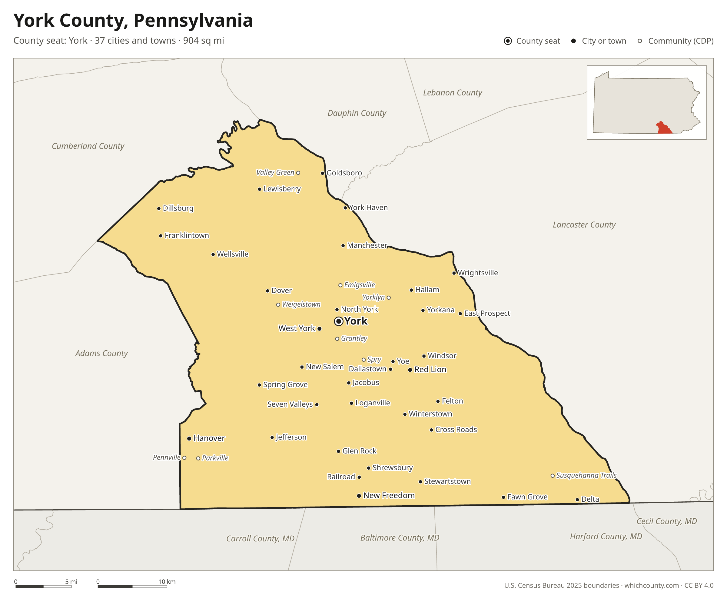
York County is the 8th most populous of Pennsylvania's 67 counties, with 473,197 people (2025 estimate). Its county seat is York. It is part of the District 8 region, one of the 11 PennDOT engineering districts. The map shows its 37 cities and towns and the 7 neighboring counties.

York County facts
- County seat
- York
- Population (2025 estimate)
- 473,197 +3.7% since 2020
- Land area
- 904 sq mi 13th largest of 67
- Water area
- 6 sq mi
- Population density
- 523 per sq mi
- Established
- 1749
- Same name
- One of 5 York Counties in the US
- Named after
- York city in North Yorkshire, England, United Kingdom
- Largest city
- York 45,342
- Median household income
- $84,829
- Cities and towns
- 37 plus 19 CDPs
- ZIP codes
- 47
- Time zone
- Eastern
- FIPS code
- 42133
Cities and towns in York County
York County has 37 incorporated cities, towns and villages. Populations count the people living inside York County; cities that cross a county line also list the other counties.
| Name | Type | Population 2025 | Also in |
|---|---|---|---|
| York (county seat) | City | 45,342 | |
| Hanover | Borough | 16,684 | |
| Red Lion | Borough | 6,523 | |
| New Freedom | Borough | 5,116 | |
| West York | Borough | 5,110 | |
| Dallastown | Borough | 4,198 | |
| Shrewsbury | Borough | 4,014 | |
| Manchester | Borough | 2,821 | |
| Hallam | Borough | 2,798 | |
| Dillsburg | Borough | 2,635 | |
| Spring Grove | Borough | 2,520 | |
| Wrightsville | Borough | 2,259 | |
| North York | Borough | 2,248 | |
| Stewartstown | Borough | 2,225 | |
| Glen Rock | Borough | 2,129 | |
| Dover | Borough | 1,959 | |
| Jacobus | Borough | 1,838 | |
| Loganville | Borough | 1,442 | |
| Mount Wolf | Borough | 1,422 | |
| Windsor | Borough | 1,420 | |
| Yoe | Borough | 1,058 | |
| East Prospect | Borough | 961 | |
| Goldsboro | Borough | 931 | |
| New Salem | Borough | 822 | |
| Delta | Borough | 713 | |
| York Haven | Borough | 687 | |
| Jefferson | Borough | 657 | |
| Winterstown | Borough | 607 | |
| Franklintown | Borough | 559 | |
| Cross Roads | Borough | 534 | |
| Felton | Borough | 505 | |
| Fawn Grove | Borough | 473 | |
| Seven Valleys | Borough | 472 | |
| Lewisberry | Borough | 378 | |
| Wellsville | Borough | 305 | |
| Railroad | Borough | 265 | |
| Yorkana | Borough | 236 |
Unincorporated communities (CDPs)
Census-designated places are communities without their own city government; the county provides their services.
| Community | Population | Also in |
|---|---|---|
| Weigelstown | 15,485 | |
| Shiloh | 11,246 | |
| East York | 9,388 | |
| Parkville | 8,128 | |
| Spry | 4,909 | |
| Grantley | 4,775 | |
| Emigsville | 4,254 | |
| Valley Green | 3,676 | |
| Stonybrook | 3,483 | |
| Valley View | 2,981 | |
| Pleasureville | 2,735 | |
| Pennville | 2,405 | |
| Susquehanna Trails | 2,251 | |
| Tyler Run | 1,814 | |
| Queens Gate | 1,602 | |
| Yorklyn | 1,525 | |
| New Market | 718 | |
| Saginaw | 553 | |
| Mount Royal | 245 |
ZIP codes in York County
47 ZIP codes reach into York County. ZIP codes ignore county lines, so some also cover a neighboring county.
- 17011 also Cumberland County
- 17019 also Cumberland and Adams counties
- 17055 also Cumberland County
- 17070 also Cumberland County
- 17301 also Adams County
- 17302
- 17309
- 17311
- 17313
- 17314
- 17315
- 17316 also Adams County
- 17317
- 17318
- 17319
- 17321
- 17322
- 17323
- 17327
- 17329
- 17331 also Adams County
- 17339
- 17342
- 17345
- 17347
- 17349
- 17352
- 17355
- 17356
- 17360
- 17361
- 17362
- 17363
- 17364
- 17365
- 17366
- 17368
- 17370
- 17371
- 17372 also Adams County
- 17401
- 17402
- 17403
- 17404
- 17406
- 17407
- 17408
Population of York County, 2020–2025
York County grew by 16,763 people (+3.7%) between April 2020 and July 2025: 501 more deaths than births and a net gain of 17,160 people from migration.
| Year (July 1) | Population |
|---|---|
| 2020 | 456,725 |
| 2021 | 459,306 |
| 2022 | 461,464 |
| 2023 | 466,068 |
| 2024 | 469,986 |
| 2025 | 473,197 |
Neighboring counties
- Lancaster County east · 563,159 people
- Adams County west · 107,594 people
- Cumberland County northwest · 277,270 people
- Harford County, Maryland southeast · 266,446 people
- Dauphin County north · 293,351 people
- Baltimore County, Maryland south · 847,650 people
- Carroll County, Maryland southwest · 176,677 people
Printable York County map
The PDF is a vector file with real text: it prints sharp on Letter paper and you can search it for a town. The PNG is 2400 pixels wide for slides and documents. Both are free to use with a credit to WhichCounty.
- PDF (Letter) (194 KB)
- PNG (2400 px) (132 KB)
Paste this code to embed the map on your site:
Sources
- Boundaries: U.S. Census Bureau, 2025 Cartographic Boundary Files (1:500,000).
- Population: Census Bureau county and city estimates, Vintage 2025. CDP populations: American Community Survey 2020–2024.
- Places and ZIP codes: Census Bureau 2026 Gazetteer and 2020 ZIP Code Tabulation Area relationship files.
- County seat, founding year and name origin: Wikidata (CC0), checked against state sources.
Back to the Pennsylvania county map with all 67 counties. Found an error? Tell us.