Lancaster County, Pennsylvania
County seat: Lancaster · Population 563,159 (2025) · 944 sq mi
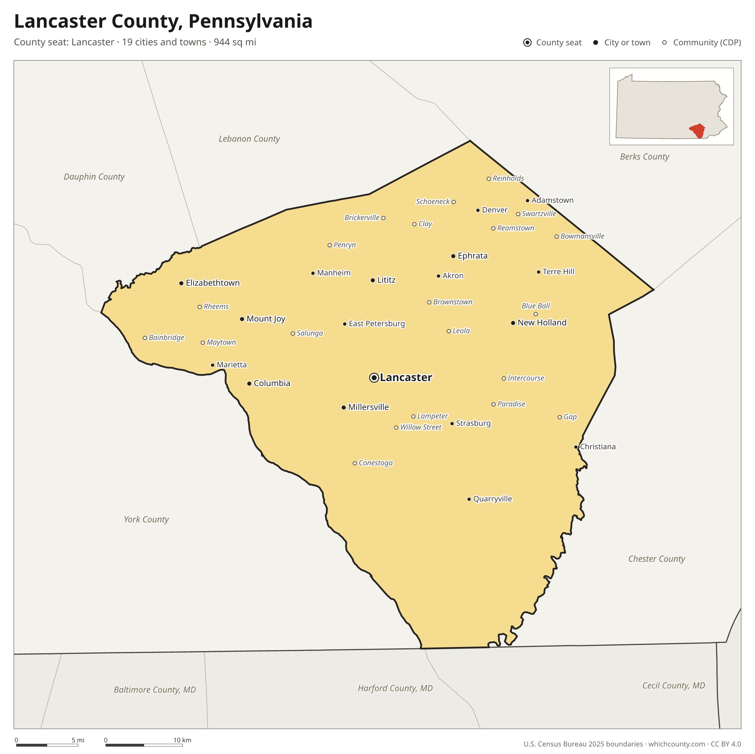
Lancaster County is the 6th most populous of Pennsylvania's 67 counties, with 563,159 people (2025 estimate). Its county seat is Lancaster. It is part of the District 8 region, one of the 11 PennDOT engineering districts. The map shows its 19 cities and towns and the 7 neighboring counties.

Lancaster County facts
- County seat
- Lancaster
- Population (2025 estimate)
- 563,159 +1.8% since 2020
- Land area
- 944 sq mi 12th largest of 67
- Water area
- 40 sq mi
- Population density
- 597 per sq mi
- Established
- 1729
- Same name
- One of 4 Lancaster Counties in the US
- Named after
- Lancaster county town of Lancashire, England
- Largest city
- Lancaster 58,366
- Median household income
- $86,959
- Cities and towns
- 19 plus 47 CDPs
- ZIP codes
- 61
- Time zone
- Eastern
- FIPS code
- 42071
Cities and towns in Lancaster County
Lancaster County has 19 incorporated cities, towns and villages. Populations count the people living inside Lancaster County; cities that cross a county line also list the other counties.
| Name | Type | Population 2025 | Also in |
|---|---|---|---|
| Lancaster (county seat) | City | 58,366 | |
| Ephrata | Borough | 13,647 | |
| Elizabethtown | Borough | 11,961 | |
| Columbia | Borough | 10,314 | |
| Lititz | Borough | 9,689 | |
| Millersville | Borough | 9,280 | |
| Mount Joy | Borough | 8,319 | |
| New Holland | Borough | 5,754 | |
| Manheim | Borough | 4,977 | |
| East Petersburg | Borough | 4,702 | |
| Akron | Borough | 4,093 | |
| Denver | Borough | 3,747 | |
| Strasburg | Borough | 3,085 | |
| Mountville | Borough | 2,977 | |
| Marietta | Borough | 2,931 | |
| Quarryville | Borough | 2,871 | |
| Adamstown | Borough | 1,932 | Berks County |
| Terre Hill | Borough | 1,282 | |
| Christiana | Borough | 1,096 |
Unincorporated communities (CDPs)
Census-designated places are communities without their own city government; the county provides their services.
| Community | Population | Also in |
|---|---|---|
| Willow Street | 9,647 | |
| Leola | 7,448 | |
| Maytown | 4,443 | |
| Brownstown | 3,650 | |
| Reamstown | 3,468 | |
| Salunga | 3,355 | |
| Bowmansville | 2,959 | |
| Rothsville | 2,934 | |
| Rheems | 2,426 | |
| Landisville | 2,168 | |
| Reinholds | 2,168 | |
| Lampeter | 2,140 | |
| Gap | 2,128 | |
| Swartzville | 1,799 | |
| Intercourse | 1,588 | |
| Bainbridge | 1,376 | |
| Clay | 1,362 | |
| Blue Ball | 1,284 | |
| Brickerville | 1,257 | |
| Penryn | 1,257 | |
| Conestoga | 1,243 | |
| Paradise | 1,091 | |
| East Earl | 1,050 | |
| Schoeneck | 1,018 | |
| Fivepointville | 904 | |
| Farmersville | 870 | |
| Stevens | 799 | |
| Georgetown | 784 | |
| Churchtown | 763 | |
| Hopeland | 760 | |
| Rohrerstown | 706 | |
| Washington Boro | 663 | |
| Soudersburg | 592 | |
| Wakefield | 573 | |
| Cambridge | 540 | Chester County |
| Bird-in-Hand | 537 | |
| Witmer | 527 | |
| Falmouth | 521 | |
| Little Britain | 439 | |
| Smoketown | 342 | |
| Refton | 321 | |
| Gordonville | 310 | |
| Kirkwood | 307 | |
| Goodville | 205 | |
| Ronks | 202 | |
| Hinkletown | 181 | |
| Morgantown | 0 | Berks County |
ZIP codes in Lancaster County
61 ZIP codes reach into Lancaster County. ZIP codes ignore county lines, so some also cover a neighboring county.
- 17022 also Dauphin County
- 17073 also Lebanon County
- 17501
- 17502
- 17504
- 17505
- 17506
- 17507
- 17508
- 17509
- 17512
- 17516
- 17517
- 17518
- 17519
- 17520
- 17522
- 17527 also Chester County
- 17529
- 17532
- 17534
- 17535
- 17536
- 17538
- 17540
- 17543
- 17545 also Lebanon County
- 17547
- 17550
- 17551
- 17552
- 17554
- 17555 also Chester and Berks counties
- 17557
- 17560
- 17562
- 17563
- 17565
- 17566
- 17568
- 17569 also Berks County
- 17570
- 17572
- 17576
- 17578
- 17579
- 17581
- 17582
- 17584
- 17601
- 17602
- 17603
- 17606
- 19310 also Chester County
- 19344 also Chester County
- 19362 also Chester County
- 19363 also Chester County
- 19501 also Berks County
- 19540 also Berks County
- 19543 also Berks and Chester counties
- 19551 also Berks and Lebanon counties
Population of Lancaster County, 2020–2025
Lancaster County grew by 10,171 people (+1.8%) between April 2020 and July 2025: 6,307 more births than deaths and a net gain of 3,724 people from migration.
| Year (July 1) | Population |
|---|---|
| 2020 | 552,819 |
| 2021 | 556,420 |
| 2022 | 557,092 |
| 2023 | 560,144 |
| 2024 | 562,062 |
| 2025 | 563,159 |
Neighboring counties
- Chester County east · 557,116 people
- York County west · 473,197 people
- Lebanon County northwest · 146,380 people
- Berks County northeast · 440,072 people
- Dauphin County northwest · 293,351 people
- Cecil County, Maryland southeast · 107,131 people
- Harford County, Maryland south · 266,446 people
Printable Lancaster County map
The PDF is a vector file with real text: it prints sharp on Letter paper and you can search it for a town. The PNG is 2400 pixels wide for slides and documents. Both are free to use with a credit to WhichCounty.
- PDF (Letter) (175 KB)
- PNG (2400 px) (127 KB)
Paste this code to embed the map on your site:
Sources
- Boundaries: U.S. Census Bureau, 2025 Cartographic Boundary Files (1:500,000).
- Population: Census Bureau county and city estimates, Vintage 2025. CDP populations: American Community Survey 2020–2024.
- Places and ZIP codes: Census Bureau 2026 Gazetteer and 2020 ZIP Code Tabulation Area relationship files.
- County seat, founding year and name origin: Wikidata (CC0), checked against state sources.
Back to the Pennsylvania county map with all 67 counties. Found an error? Tell us.