Western Connecticut Planning Region, Connecticut
Population 640,482 (2025) · 532 sq mi
Western Connecticut Planning Region is the 2nd most populous of Connecticut's 9 planning regions, with 640,482 people (2025 estimate). The map shows its 4 cities and towns and the 8 neighboring counties.

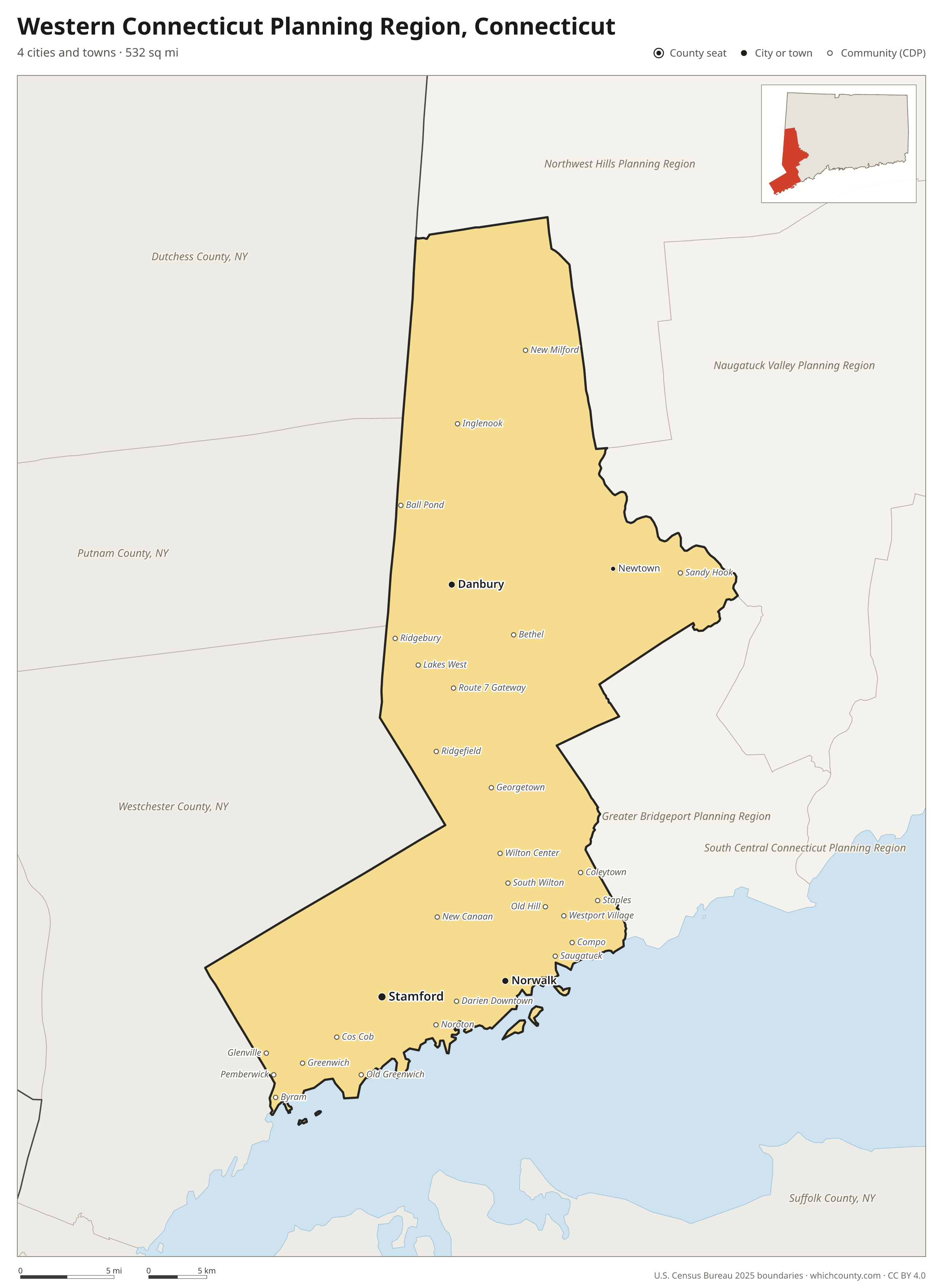
Western Connecticut Planning Region facts
- Population (2025 estimate)
- 640,482 +3.2% since 2020
- Land area
- 532 sq mi 5th largest of 9
- Water area
- 116 sq mi
- Population density
- 1,204 per sq mi
- Largest city
- Stamford 139,535
- Median household income
- $128,188
- Cities and towns
- 4 plus 62 CDPs
- ZIP codes
- 35
- Time zone
- Eastern
- FIPS code
- 09190
Cities and towns in Western Connecticut Planning Region
Western Connecticut Planning Region has 4 incorporated cities, towns and villages. Populations count the people living inside Western Connecticut Planning Region; cities that cross a county line also list the other counties.
| Name | Type | Population 2025 | Also in |
|---|---|---|---|
| Stamford | City | 139,535 | |
| Norwalk | City | 94,508 | |
| Danbury | City | 89,033 | |
| Newtown | Borough | 1,980 |
Unincorporated communities (CDPs)
Census-designated places are communities without their own city government; the county provides their services.
| Community | Population | Also in |
|---|---|---|
| Greenwich | 14,792 | |
| Bethel | 11,404 | |
| Sandy Hook | 9,863 | |
| Riverside | 8,954 | |
| New Milford | 8,188 | |
| Cos Cob | 7,546 | |
| Staples | 7,340 | |
| Ridgefield | 6,970 | |
| Old Greenwich | 6,936 | |
| New Canaan | 6,896 | |
| Noroton | 5,539 | |
| Byram | 4,633 | |
| Pemberwick | 3,665 | |
| Coleytown | 3,472 | |
| Compo | 3,410 | |
| Greens Farms | 3,229 | |
| Westport Village | 3,021 | |
| Old Hill | 2,990 | |
| Tokeneke | 2,951 | |
| Saugatuck | 2,925 | |
| Noroton Heights | 2,782 | |
| Glenville | 2,656 | |
| Ball Pond | 2,627 | |
| Ridgebury | 2,060 | |
| Georgetown | 1,932 | |
| Wilton Center | 1,682 | |
| South Wilton | 1,444 | |
| Lakes West | 1,395 | |
| Darien Downtown | 1,242 | |
| Lakes East | 1,227 | |
| Poplar Plains | 1,141 | |
| Route 7 Gateway | 1,108 | |
| Inglenook | 1,056 | |
| Weston | 966 | |
| Candlewood Orchards | 900 | |
| Bigelow Corners | 884 | |
| Cannondale | 758 | |
| Gaylordsville | 740 | |
| Indian Field | 716 | |
| Botsford | 635 | |
| Candlewood Isle | 633 | |
| Candlewood Shores | 525 | |
| Mamanasco Lake | 499 | |
| Rock Ridge | 482 | |
| Taylor Corners | 481 | |
| West Mountain | 387 | |
| Lakeside Woods | 363 | |
| Dodgingtown | 285 | |
| Knollcrest | 266 | |
| Redding Center | 262 | |
| Candlewood Lake Club | 255 | |
| Brookfield Center | 248 | |
| Candlewood Knolls | 224 | |
| Hawleyville | 164 | |
| Bridgewater | 130 | |
| Topstone | 122 | |
| Sail Harbor | 120 | |
| Chimney Point | 117 | |
| Branchville | 88 | |
| Bogus Hill | 80 | |
| Kellogg Point | 22 | |
| Sherman | 0 |
ZIP codes in Western Connecticut Planning Region
35 ZIP codes reach into Western Connecticut Planning Region. ZIP codes ignore county lines, so some also cover a neighboring county.
- 06470
- 06482
- 06752 also Northwest Hills Planning Region
- 06755
- 06776 also Northwest Hills Planning Region
- 06784
- 06794 also Northwest Hills Planning Region
- 06801
- 06804
- 06807
- 06810
- 06811
- 06812
- 06820
- 06830
- 06831
- 06840
- 06850
- 06851
- 06853
- 06854
- 06855
- 06870
- 06877
- 06878
- 06880 also Greater Bridgeport Planning Region
- 06883
- 06896
- 06897
- 06901
- 06902
- 06903
- 06905
- 06906
- 06907
Population of Western Connecticut Planning Region, 2020–2025
Western Connecticut Planning Region grew by 19,582 people (+3.2%) between April 2020 and July 2025: 7,210 more births than deaths and a net gain of 11,947 people from migration.
| Year (July 1) | Population |
|---|---|
| 2020 | 618,740 |
| 2021 | 624,102 |
| 2022 | 626,146 |
| 2023 | 630,270 |
| 2024 | 637,721 |
| 2025 | 640,482 |
Neighboring counties
- Westchester County, New York southwest · 1,015,743 people
- Greater Bridgeport Planning Region southeast · 337,697 people
- Northwest Hills Planning Region north · 114,690 people
- Naugatuck Valley Planning Region northeast · 463,349 people
- Putnam County, New York northwest · 99,028 people
- Nassau County, New York south · 1,398,939 people
- Dutchess County, New York northwest · 300,708 people
- Suffolk County, New York southeast · 1,546,090 people
Printable Western Connecticut Planning Region map
The PDF is a vector file with real text: it prints sharp on Letter paper and you can search it for a town. The PNG is 2400 pixels wide for slides and documents. Both are free to use with a credit to WhichCounty.
- PDF (Letter) (196 KB)
- PNG (2400 px) (166 KB)
Paste this code to embed the map on your site:
Cite this map
- APA
- WhichCounty. (2026, October 4). Western Connecticut Planning Region, Connecticut Map [Map]. https://whichcounty.com/connecticut/western-connecticut-planning-region/
- MLA
- “Western Connecticut Planning Region, Connecticut Map.” WhichCounty, 4 Oct. 2026, whichcounty.com/connecticut/western-connecticut-planning-region/.
- Chicago
- WhichCounty. “Western Connecticut Planning Region, Connecticut Map.” Last modified October 4, 2026. https://whichcounty.com/connecticut/western-connecticut-planning-region/.
Sources
- Boundaries: U.S. Census Bureau, 2025 Cartographic Boundary Files (1:500,000).
- Population: Census Bureau county and city estimates, Vintage 2025. CDP populations: American Community Survey 2020–2024.
- Places and ZIP codes: Census Bureau 2026 Gazetteer and 2020 ZIP Code Tabulation Area relationship files.
- County seat, founding year and name origin: Wikidata (CC0), checked against state sources.
Back to the Connecticut county map with all 9 planning regions. Found an error? Tell us.