Sussex County, New Jersey
County seat: Newton · Population 148,063 (2025) · 519 sq mi
Sussex County is the 17th most populous of New Jersey's 21 counties, with 148,063 people (2025 estimate). Its county seat is Newton. The map shows its 9 cities and towns and the 6 neighboring counties.

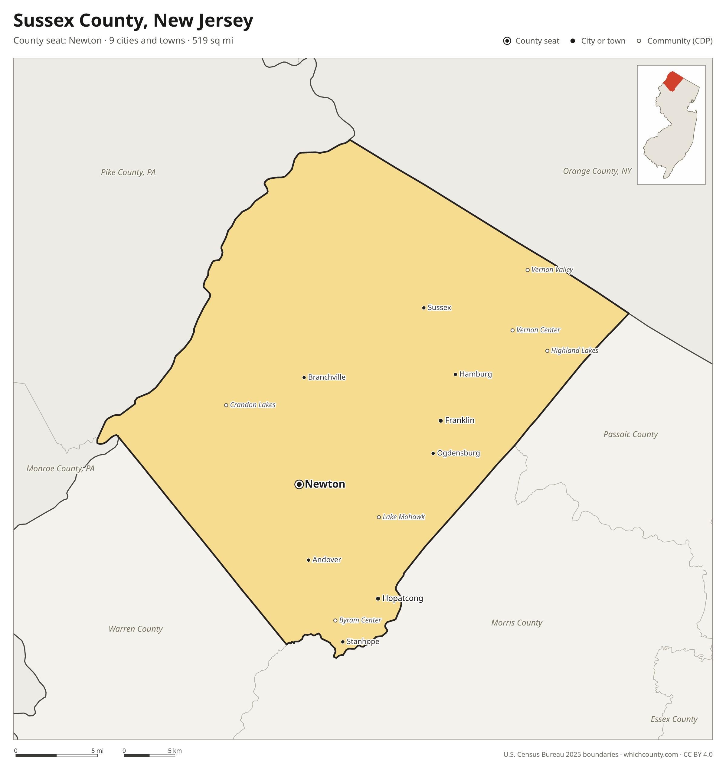
Sussex County facts
- County seat
- Newton
- Population (2025 estimate)
- 148,063 +2.7% since 2020
- Land area
- 519 sq mi 4th largest of 21
- Water area
- 17 sq mi
- Population density
- 286 per sq mi
- Established
- 1753
- Same name
- One of 3 Sussex Counties in the US
- Named after
- Sussex historic county of England, United Kingdom
- Largest city
- Vernon 22,965
- Median household income
- $116,186
- Cities and towns
- 9 plus 9 CDPs
- ZIP codes
- 22
- Time zone
- Eastern
- FIPS code
- 34037
Cities and towns in Sussex County
Sussex County has 9 incorporated cities, towns and villages. Populations count the people living inside Sussex County; cities that cross a county line also list the other counties.
| Name | Type | Population 2025 | Also in |
|---|---|---|---|
| Hopatcong | Borough | 14,824 | |
| Newton (county seat) | Town | 8,486 | |
| Franklin | Borough | 5,083 | |
| Stanhope | Borough | 3,614 | |
| Hamburg | Borough | 3,345 | |
| Ogdensburg | Borough | 2,319 | |
| Sussex | Borough | 2,079 | |
| Branchville | Borough | 809 | |
| Andover | Borough | 614 |
Unincorporated communities (CDPs)
Census-designated places are communities without their own city government; the county provides their services.
| Community | Population | Also in |
|---|---|---|
| Lake Mohawk | 9,508 | |
| Highland Lakes | 3,852 | |
| Byram Center | 2,188 | |
| Vernon Valley | 1,532 | |
| Vernon Center | 1,503 | |
| Crandon Lakes | 1,293 | |
| Layton | 967 | |
| Upper Greenwood Lake | 28 | Passaic County |
| Ross Corner | 24 |
ZIP codes in Sussex County
22 ZIP codes reach into Sussex County. ZIP codes ignore county lines, so some also cover a neighboring county.
- 07416
- 07418
- 07419
- 07421 also Passaic County
- 07422
- 07439
- 07460 also Passaic and Morris counties
- 07461
- 07462
- 07821 also Warren County
- 07822
- 07825 also Warren County
- 07826
- 07827
- 07843
- 07848
- 07849 also Morris County
- 07851
- 07860 also Warren County
- 07871
- 07874 also Warren County
- 07881
Population of Sussex County, 2020–2025
Sussex County grew by 3,828 people (+2.7%) between April 2020 and July 2025: 95 more deaths than births and a net gain of 4,057 people from migration.
| Year (July 1) | Population |
|---|---|
| 2020 | 143,877 |
| 2021 | 145,706 |
| 2022 | 145,668 |
| 2023 | 146,328 |
| 2024 | 147,445 |
| 2025 | 148,063 |
Neighboring counties
- Pike County, Pennsylvania northwest · 62,808 people
- Morris County south · 524,251 people
- Orange County, New York northeast · 417,669 people
- Warren County southwest · 112,953 people
- Passaic County east · 531,624 people
- Monroe County, Pennsylvania west · 167,179 people
Printable Sussex County map
The PDF is a vector file with real text: it prints sharp on Letter paper and you can search it for a town. The PNG is 2400 pixels wide for slides and documents. Both are free to use with a credit to WhichCounty.
- PDF (Letter) (112 KB)
- PNG (2400 px) (107 KB)
Paste this code to embed the map on your site:
Sources
- Boundaries: U.S. Census Bureau, 2025 Cartographic Boundary Files (1:500,000).
- Population: Census Bureau county and city estimates, Vintage 2025. CDP populations: American Community Survey 2020–2024.
- Places and ZIP codes: Census Bureau 2026 Gazetteer and 2020 ZIP Code Tabulation Area relationship files.
- County seat, founding year and name origin: Wikidata (CC0), checked against state sources.
Back to the New Jersey county map with all 21 counties. Found an error? Tell us.