Warren County, New Jersey
County seat: Belvidere · Population 112,953 (2025) · 357 sq mi
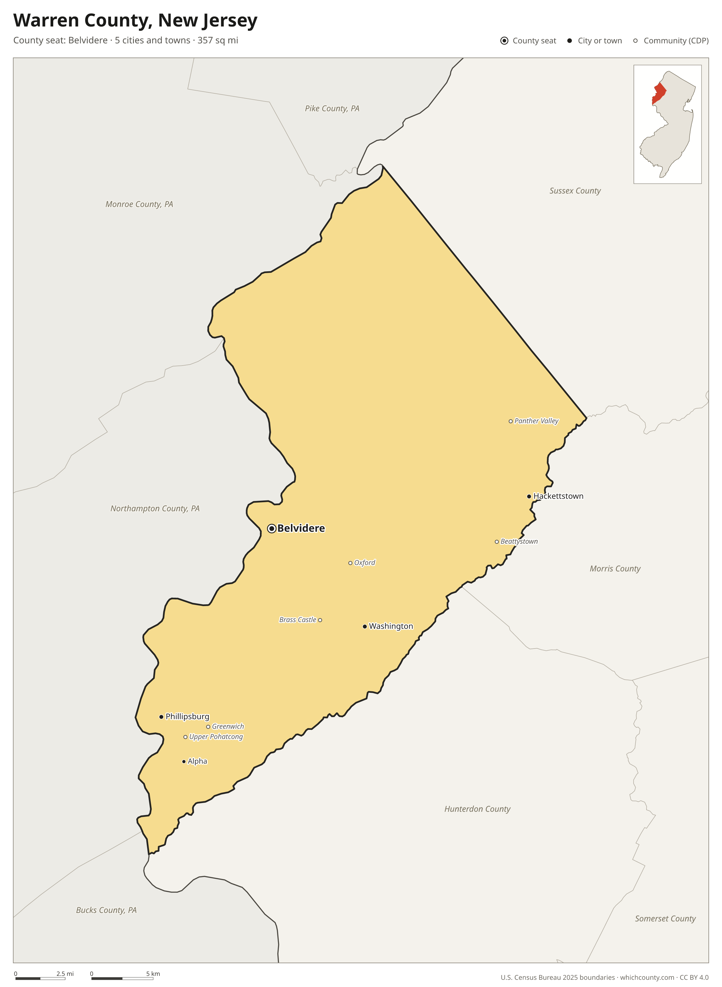
Warren County is the 19th most populous of New Jersey's 21 counties, with 112,953 people (2025 estimate). Its county seat is Belvidere. The map shows its 5 cities and towns and the 6 neighboring counties.

Warren County facts
- County seat
- Belvidere
- Population (2025 estimate)
- 112,953 +3% since 2020
- Land area
- 357 sq mi 9th largest of 21
- Water area
- 6 sq mi
- Population density
- 317 per sq mi
- Established
- 1824
- Same name
- One of 14 Warren Counties in the US
- Named after
- Joseph Warren American doctor (1741-1775)
- Largest city
- Phillipsburg 15,456
- Median household income
- $100,869
- Cities and towns
- 5 plus 36 CDPs
- ZIP codes
- 22
- Time zone
- Eastern
- FIPS code
- 34041
Cities and towns in Warren County
Warren County has 5 incorporated cities, towns and villages. Populations count the people living inside Warren County; cities that cross a county line also list the other counties.
| Name | Type | Population 2025 | Also in |
|---|---|---|---|
| Phillipsburg | Town | 15,456 | |
| Hackettstown | Town | 10,185 | |
| Washington | Borough | 7,326 | |
| Belvidere (county seat) | Town | 2,551 | |
| Alpha | Borough | 2,362 |
Unincorporated communities (CDPs)
Census-designated places are communities without their own city government; the county provides their services.
| Community | Population | Also in |
|---|---|---|
| Beattystown | 4,917 | |
| Panther Valley | 4,553 | |
| Greenwich | 2,679 | |
| Brass Castle | 1,936 | |
| Upper Pohatcong | 1,876 | |
| Oxford | 1,122 | |
| Vienna | 999 | |
| Stewartsville | 710 | |
| Brookfield | 673 | |
| Anderson | 607 | |
| Great Meadows | 604 | |
| Mountain Lake | 574 | |
| Lopatcong Overlook | 453 | |
| Johnsonburg | 406 | |
| Delaware Park | 374 | |
| Blairstown | 344 | |
| New Village | 335 | |
| Port Colden | 332 | |
| Finesville | 301 | |
| Silver Lake | 284 | |
| Harmony | 263 | |
| Asbury | 241 | |
| Hainesburg | 239 | |
| Mount Hermon | 207 | |
| Buttzville | 198 | |
| Marksboro | 193 | |
| Hope | 185 | |
| Columbia | 174 | |
| Port Murray | 138 | |
| Upper Stewartsville | 128 | |
| Broadway | 115 | |
| Hutchinson | 114 | |
| Bridgeville | 104 | |
| Delaware | 101 | |
| Brainards | 98 | |
| Allamuchy | 91 |
ZIP codes in Warren County
22 ZIP codes reach into Warren County. ZIP codes ignore county lines, so some also cover a neighboring county.
- 07820
- 07821 also Sussex County
- 07823
- 07825 also Sussex County
- 07831
- 07832
- 07833
- 07838
- 07840 also Morris County
- 07844
- 07846
- 07860 also Sussex County
- 07863
- 07865 also Hunterdon and Morris counties
- 07874 also Sussex County
- 07880
- 07882 also Hunterdon County
- 08802 also Hunterdon County
- 08804 also Hunterdon County
- 08827 also Hunterdon County
- 08865
- 08886
Population of Warren County, 2020–2025
Warren County grew by 3,323 people (+3%) between April 2020 and July 2025: 708 more deaths than births and a net gain of 4,091 people from migration.
| Year (July 1) | Population |
|---|---|
| 2020 | 109,431 |
| 2021 | 110,580 |
| 2022 | 111,018 |
| 2023 | 111,651 |
| 2024 | 112,424 |
| 2025 | 112,953 |
Neighboring counties
- Northampton County, Pennsylvania southwest · 324,411 people
- Hunterdon County south · 131,781 people
- Sussex County northeast · 148,063 people
- Monroe County, Pennsylvania northwest · 167,179 people
- Morris County east · 524,251 people
- Bucks County, Pennsylvania south · 647,828 people
Printable Warren County map
The PDF is a vector file with real text: it prints sharp on Letter paper and you can search it for a town. The PNG is 2400 pixels wide for slides and documents. Both are free to use with a credit to WhichCounty.
- PDF (Letter) (115 KB)
- PNG (2400 px) (120 KB)
Paste this code to embed the map on your site:
Sources
- Boundaries: U.S. Census Bureau, 2025 Cartographic Boundary Files (1:500,000).
- Population: Census Bureau county and city estimates, Vintage 2025. CDP populations: American Community Survey 2020–2024.
- Places and ZIP codes: Census Bureau 2026 Gazetteer and 2020 ZIP Code Tabulation Area relationship files.
- County seat, founding year and name origin: Wikidata (CC0), checked against state sources.
Back to the New Jersey county map with all 21 counties. Found an error? Tell us.