Bucks County, Pennsylvania
County seat: Doylestown · Population 647,828 (2025) · 604 sq mi
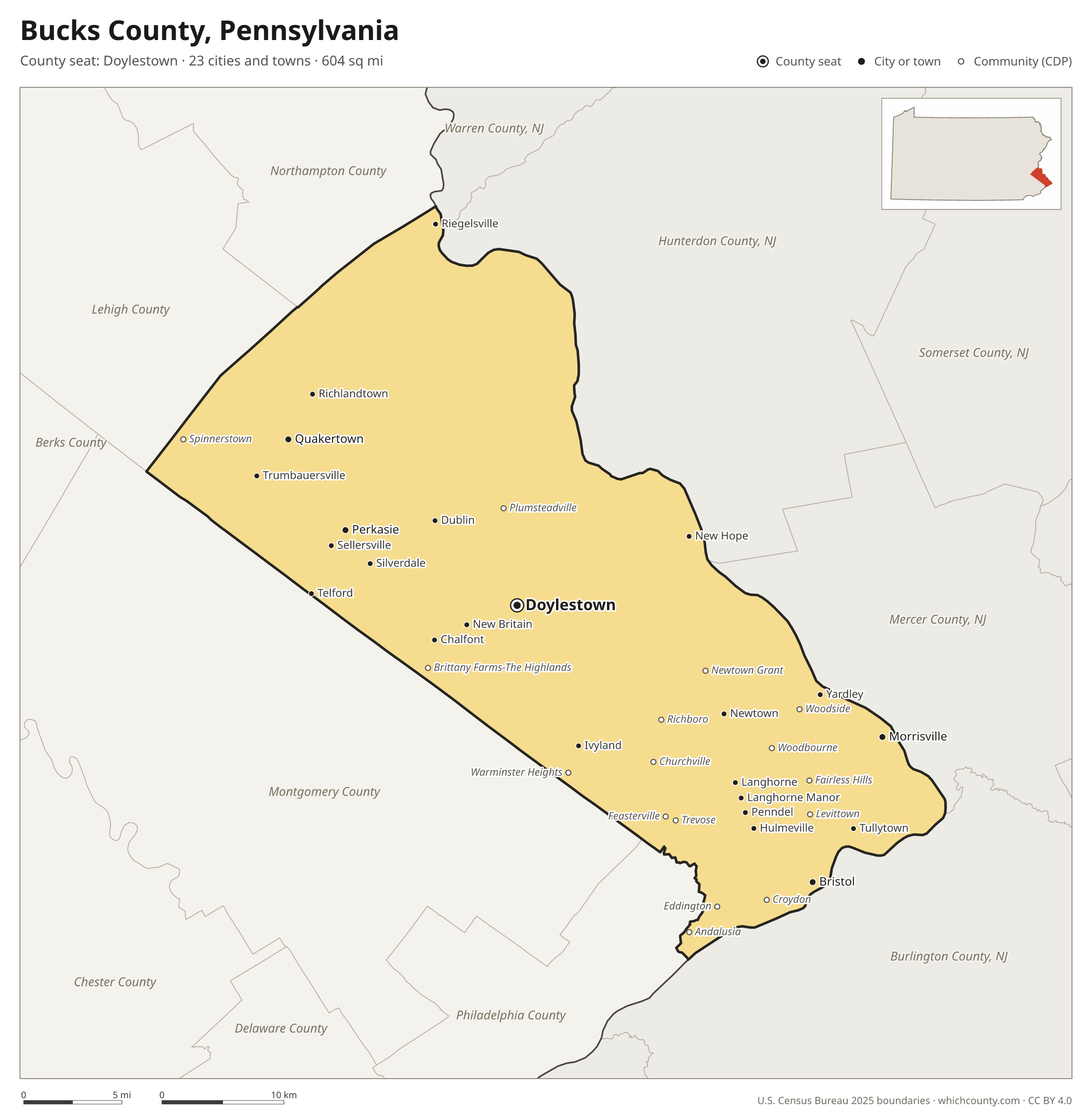
Bucks County is the 4th most populous of Pennsylvania's 67 counties, with 647,828 people (2025 estimate). Its county seat is Doylestown. It is part of the District 6 region, one of the 11 PennDOT engineering districts. The map shows its 23 cities and towns and the 8 neighboring counties.

Bucks County facts
- County seat
- Doylestown
- Population (2025 estimate)
- 647,828 +0.2% since 2020
- Land area
- 604 sq mi 37th largest of 67
- Water area
- 18 sq mi
- Population density
- 1,072 per sq mi
- Established
- 1682
- Named after
- Buckinghamshire ceremonial county in England, UK (use Q21694636 for administrative unitary authority)
- Largest city
- Bensalem 62,783
- Median household income
- $114,764
- Cities and towns
- 23 plus 21 CDPs
- ZIP codes
- 60
- Time zone
- Eastern
- FIPS code
- 42017
Cities and towns in Bucks County
Bucks County has 23 incorporated cities, towns and villages. Populations count the people living inside Bucks County; cities that cross a county line also list the other counties.
| Name | Type | Population 2025 | Also in |
|---|---|---|---|
| Bristol | Borough | 9,970 | |
| Morrisville | Borough | 9,665 | |
| Perkasie | Borough | 9,312 | |
| Quakertown | Borough | 9,235 | |
| Doylestown (county seat) | Borough | 8,330 | |
| Sellersville | Borough | 4,501 | |
| Chalfont | Borough | 4,419 | |
| New Britain | Borough | 2,799 | |
| New Hope | Borough | 2,629 | |
| Yardley | Borough | 2,577 | |
| Penndel | Borough | 2,507 | |
| Dublin | Borough | 2,436 | |
| Newtown | Borough | 2,257 | |
| Tullytown | Borough | 2,228 | |
| Telford | Borough | 2,209 | Montgomery County |
| Langhorne | Borough | 1,620 | |
| Langhorne Manor | Borough | 1,467 | |
| Richlandtown | Borough | 1,335 | |
| Hulmeville | Borough | 982 | |
| Ivyland | Borough | 943 | |
| Trumbauersville | Borough | 881 | |
| Riegelsville | Borough | 837 | |
| Silverdale | Borough | 793 |
Unincorporated communities (CDPs)
Census-designated places are communities without their own city government; the county provides their services.
| Community | Population | Also in |
|---|---|---|
| Levittown | 50,926 | |
| Croydon | 9,684 | |
| Fairless Hills | 8,827 | |
| Richboro | 6,963 | |
| Newtown Grant | 6,193 | |
| Churchville | 6,084 | |
| Brittany Farms-The Highlands | 4,571 | |
| Warminster Heights | 3,940 | |
| Woodbourne | 3,834 | |
| Trevose | 3,635 | |
| Village Shires | 3,503 | |
| Plumsteadville | 2,592 | |
| Woodside | 2,491 | |
| Feasterville | 2,461 | |
| Andalusia | 2,251 | |
| Spinnerstown | 1,780 | |
| Eddington | 1,606 | |
| Parkland | 1,599 | |
| Cornwells Heights | 1,319 | |
| Milford Square | 1,312 | |
| Blooming Glen | 868 |
ZIP codes in Bucks County
60 ZIP codes reach into Bucks County. ZIP codes ignore county lines, so some also cover a neighboring county.
- 18036 also Lehigh County
- 18041 also Montgomery, Lehigh and Berks counties
- 18042 also Northampton County
- 18054 also Montgomery County
- 18055 also Northampton County
- 18073 also Montgomery County
- 18077 also Northampton County
- 18081
- 18901
- 18902
- 18912
- 18913
- 18914 also Montgomery County
- 18917
- 18920
- 18921
- 18923
- 18925
- 18927
- 18929
- 18930
- 18932
- 18933
- 18935
- 18938
- 18940
- 18942
- 18944
- 18946
- 18947
- 18950
- 18951 also Lehigh County
- 18954
- 18955
- 18960
- 18962
- 18964 also Montgomery County
- 18966
- 18969 also Montgomery County
- 18970
- 18972
- 18974
- 18976
- 18977
- 18980
- 19006 also Montgomery County
- 19007
- 19020
- 19021
- 19030
- 19040 also Montgomery County
- 19047
- 19053
- 19054
- 19055
- 19056
- 19057
- 19067
- 19440 also Montgomery County
- 19454 also Montgomery County
Population of Bucks County, 2020–2025
Bucks County grew by 1,276 people (+0.2%) between April 2020 and July 2025: 5,978 more deaths than births and a net gain of 6,969 people from migration.
| Year (July 1) | Population |
|---|---|
| 2020 | 646,212 |
| 2021 | 647,792 |
| 2022 | 646,351 |
| 2023 | 647,751 |
| 2024 | 648,416 |
| 2025 | 647,828 |
Neighboring counties
- Montgomery County southwest · 877,643 people
- Hunterdon County, New Jersey northeast · 131,781 people
- Mercer County, New Jersey east · 399,289 people
- Burlington County, New Jersey southeast · 481,439 people
- Lehigh County northwest · 384,383 people
- Philadelphia County south · 1,574,281 people
- Northampton County north · 324,411 people
- Warren County, New Jersey north · 112,953 people
Printable Bucks County map
The PDF is a vector file with real text: it prints sharp on Letter paper and you can search it for a town. The PNG is 2400 pixels wide for slides and documents. Both are free to use with a credit to WhichCounty.
- PDF (Letter) (211 KB)
- PNG (2400 px) (162 KB)
Paste this code to embed the map on your site:
Sources
- Boundaries: U.S. Census Bureau, 2025 Cartographic Boundary Files (1:500,000).
- Population: Census Bureau county and city estimates, Vintage 2025. CDP populations: American Community Survey 2020–2024.
- Places and ZIP codes: Census Bureau 2026 Gazetteer and 2020 ZIP Code Tabulation Area relationship files.
- County seat, founding year and name origin: Wikidata (CC0), checked against state sources.
Back to the Pennsylvania county map with all 67 counties. Found an error? Tell us.