Blair County, Pennsylvania
County seat: Hollidaysburg · Population 119,541 (2025) · 525 sq mi
Blair County is the 28th most populous of Pennsylvania's 67 counties, with 119,541 people (2025 estimate). Its county seat is Hollidaysburg. It is part of the District 9 region, one of the 11 PennDOT engineering districts. The map shows its 10 cities and towns and the 5 neighboring counties.

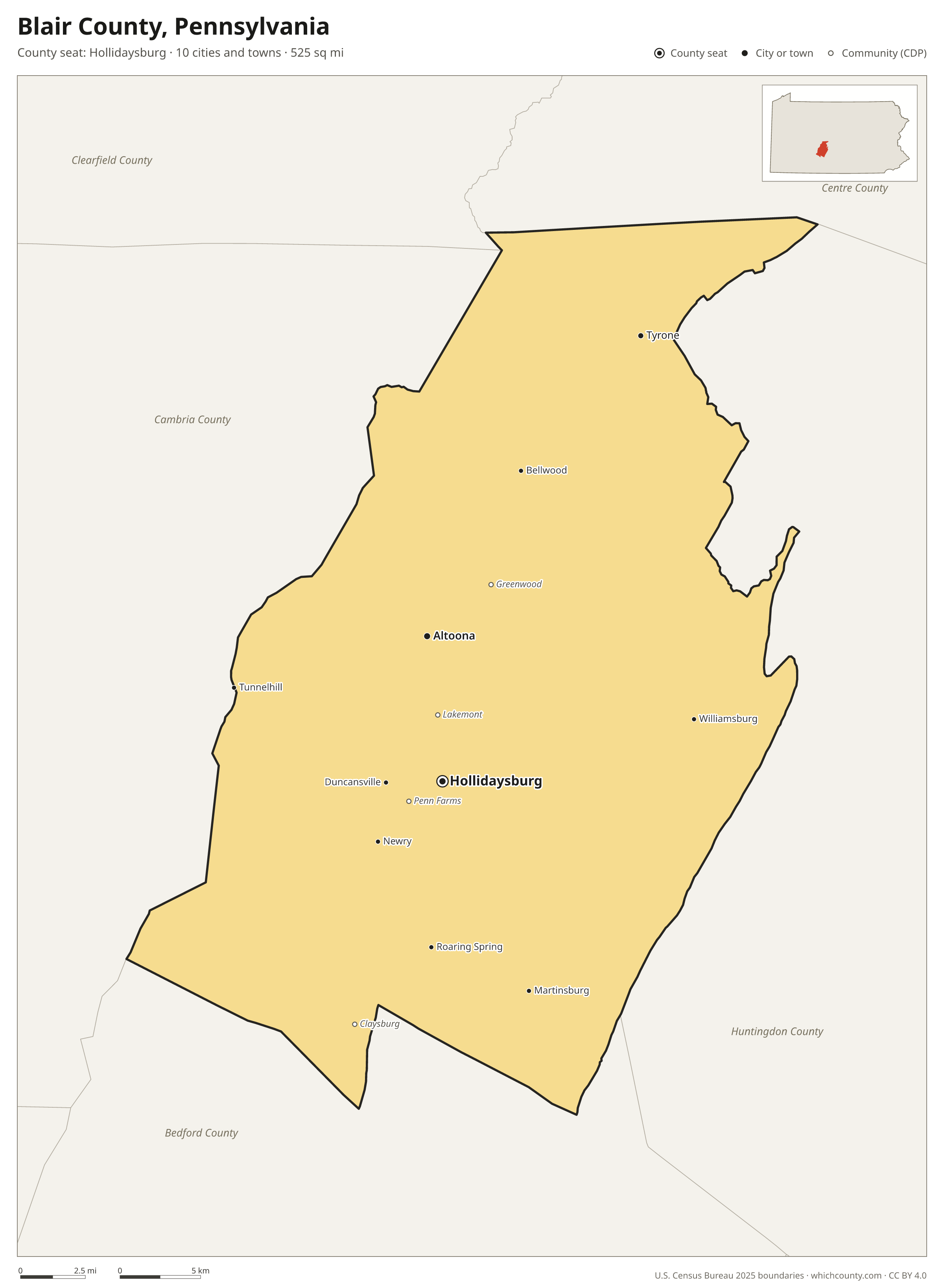
Blair County facts
- County seat
- Hollidaysburg
- Population (2025 estimate)
- 119,541 −2.7% since 2020
- Land area
- 525 sq mi 43rd largest of 67
- Water area
- 1 sq mi
- Population density
- 228 per sq mi
- Established
- 1846
- Named after
- John Blair Pennsylvania state legislator
- Largest city
- Altoona 42,347
- Median household income
- $62,382
- Cities and towns
- 10 plus 84 CDPs
- ZIP codes
- 20
- Time zone
- Eastern
- FIPS code
- 42013
Cities and towns in Blair County
Blair County has 10 incorporated cities, towns and villages. Populations count the people living inside Blair County; cities that cross a county line also list the other counties.
| Name | Type | Population 2025 | Also in |
|---|---|---|---|
| Altoona | City | 42,347 | |
| Hollidaysburg (county seat) | Borough | 5,470 | |
| Tyrone | Borough | 5,226 | |
| Roaring Spring | Borough | 2,280 | |
| Martinsburg | Borough | 1,811 | |
| Bellwood | Borough | 1,748 | |
| Duncansville | Borough | 1,207 | |
| Williamsburg | Borough | 1,196 | |
| Newry | Borough | 221 | |
| Tunnelhill | Borough | 104 | Cambria County |
Unincorporated communities (CDPs)
Census-designated places are communities without their own city government; the county provides their services.
| Community | Population | Also in |
|---|---|---|
| Greenwood | 2,853 | |
| Penn Farms | 2,508 | |
| Loop | 2,039 | |
| Lakemont | 1,644 | |
| Claysburg | 1,244 | |
| Tipton | 730 | |
| Juniata Gap | 691 | |
| East Freedom | 597 | |
| Sylvan Hills | 578 | |
| Grazierville | 511 | |
| Eldorado | 476 | |
| Foot of Ten | 466 | |
| Sunbrook | 440 | |
| Cross Keys | 420 | |
| Sproul | 393 | |
| Olivia | 387 | |
| Pinecroft | 350 | |
| Homewood at Martinsburg | 332 | |
| East Altoona | 324 | |
| Newburg | 306 | |
| Roots | 287 | |
| Bald Eagle | 272 | |
| Mill Run | 253 | |
| Robeson Extension | 247 | |
| Elberta | 234 | |
| Reightown | 227 | |
| Sickles Corner | 223 | |
| Fort Fetter | 218 | |
| Ore Hill | 214 | |
| McKee | 208 | |
| Northwood | 206 | |
| Henrietta | 188 | |
| Yellow Springs | 167 | |
| Vicksburg | 165 | |
| Friesville | 161 | |
| Geeseytown | 156 | |
| Skelp | 139 | |
| Charlottsville | 134 | |
| Carson Valley | 133 | |
| Fredericksburg | 131 | |
| East Sharpsburg | 129 | |
| Red Hill | 116 | |
| Puzzletown | 112 | |
| Shelltown | 93 | |
| Spring Drive Mobile Home Park | 92 | |
| Oreminea | 87 | |
| Nealmont | 85 | |
| Dumb Hundred | 82 | |
| Shellytown | 82 | |
| Cove Forge | 80 | |
| Clappertown | 73 | |
| Reservoir | 67 | |
| Curryville | 66 | |
| Cotton Town | 60 | |
| Klahr | 58 | |
| Canan Station | 53 | |
| Brooks Mill | 50 | |
| Linds Crossing | 40 | |
| Culp | 39 | |
| Tyrone Forge | 39 | |
| Wopsononock | 38 | |
| Reese | 37 | |
| St. Clair | 37 | |
| Fisherville | 35 | |
| Franklin Forge | 31 | |
| Blue Knob | 29 | |
| Larke | 26 | |
| Jugtown | 23 | |
| Royer | 23 | |
| Vail | 23 | |
| Gray | 21 | |
| Point View | 15 | |
| Beavertown | 10 | |
| Martinsburg Junction | 8 | |
| Millerstown | 5 | |
| Canoe Creek | 4 | |
| Ganister | 3 | |
| Fostoria | 0 | |
| Frankstown | 0 | |
| Ironville | 0 | |
| Leamersville | 0 | |
| Moores Mill | 0 | |
| Ski Gap | 0 | |
| Smith Corner | 0 |
ZIP codes in Blair County
20 ZIP codes reach into Blair County. ZIP codes ignore county lines, so some also cover a neighboring county.
- 15946 also Cambria and Bedford counties
- 16601
- 16602
- 16613 also Cambria County
- 16617
- 16625 also Bedford County
- 16631
- 16635
- 16636 also Cambria County
- 16637
- 16641 also Cambria County
- 16648
- 16655 also Bedford County
- 16662 also Bedford County
- 16665
- 16673 also Bedford County
- 16682
- 16684
- 16686 also Huntingdon and Centre counties
- 16693
Population of Blair County, 2020–2025
Blair County shrank by 3,283 people (−2.7%) between April 2020 and July 2025: 3,168 more deaths than births and a net loss of 186 people from migration.
| Year (July 1) | Population |
|---|---|
| 2020 | 122,667 |
| 2021 | 122,147 |
| 2022 | 120,774 |
| 2023 | 120,360 |
| 2024 | 120,051 |
| 2025 | 119,541 |
Neighboring counties
- Huntingdon County east · 43,001 people
- Cambria County west · 128,968 people
- Bedford County south · 47,480 people
- Centre County northeast · 157,393 people
- Clearfield County north · 78,100 people
Printable Blair County map
The PDF is a vector file with real text: it prints sharp on Letter paper and you can search it for a town. The PNG is 2400 pixels wide for slides and documents. Both are free to use with a credit to WhichCounty.
- PDF (Letter) (105 KB)
- PNG (2400 px) (101 KB)
Paste this code to embed the map on your site:
Sources
- Boundaries: U.S. Census Bureau, 2025 Cartographic Boundary Files (1:500,000).
- Population: Census Bureau county and city estimates, Vintage 2025. CDP populations: American Community Survey 2020–2024.
- Places and ZIP codes: Census Bureau 2026 Gazetteer and 2020 ZIP Code Tabulation Area relationship files.
- County seat, founding year and name origin: Wikidata (CC0), checked against state sources.
Back to the Pennsylvania county map with all 67 counties. Found an error? Tell us.