Clearfield County, Pennsylvania
County seat: Clearfield · Population 78,100 (2025) · 1,145 sq mi
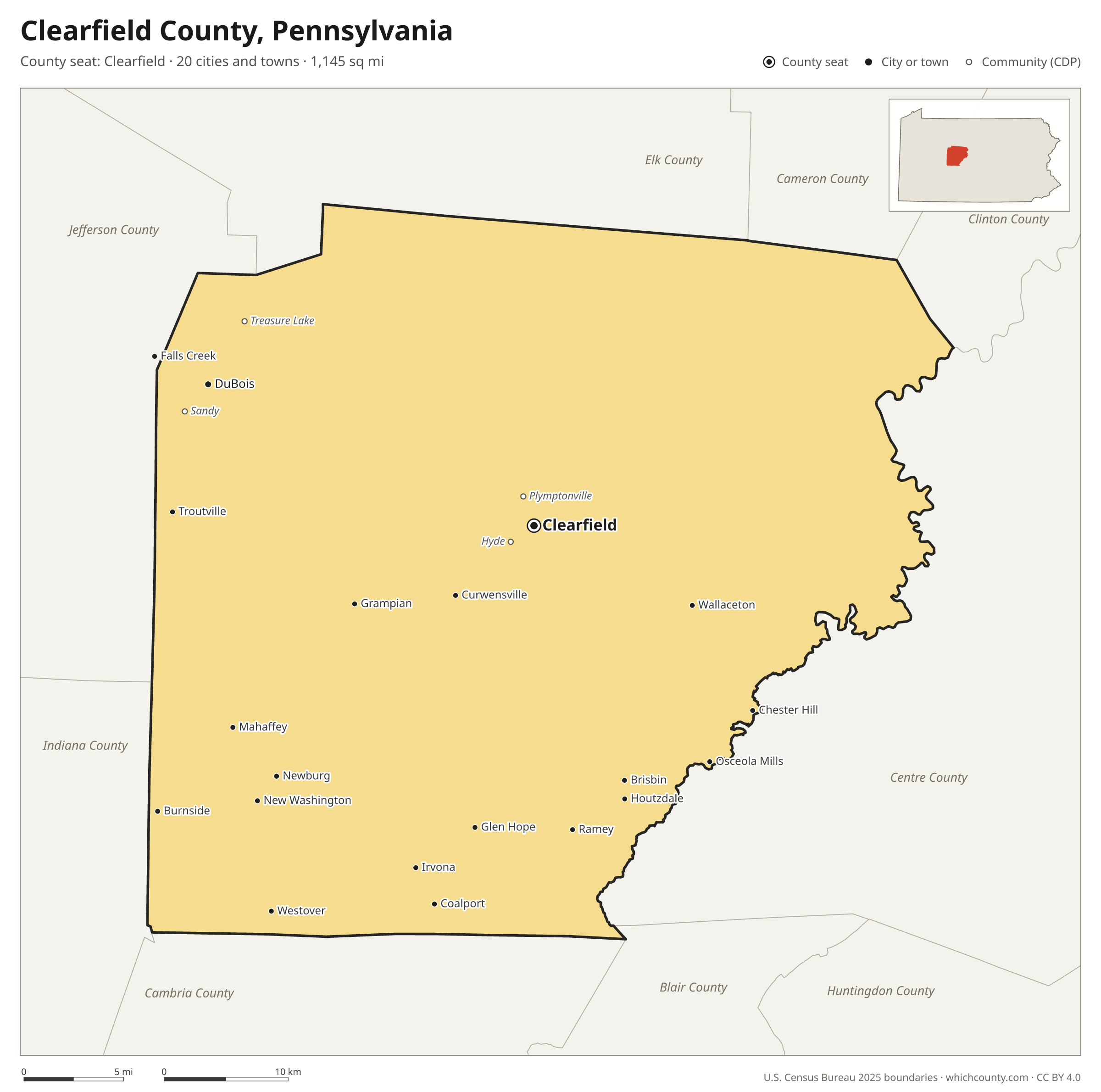
Clearfield County is the 36th most populous of Pennsylvania's 67 counties, with 78,100 people (2025 estimate). Its county seat is Clearfield. It is part of the District 2 region, one of the 11 PennDOT engineering districts. The map shows its 20 cities and towns and the 8 neighboring counties.

Clearfield County facts
- County seat
- Clearfield
- Population (2025 estimate)
- 78,100 −3.1% since 2020
- Land area
- 1,145 sq mi 3rd largest of 67
- Water area
- 9 sq mi
- Population density
- 68 per sq mi
- Established
- 1804
- Named after
- field area of land used for agricultural purposes
- Largest city
- Sandy 11,628
- Median household income
- $62,152
- Cities and towns
- 20 plus 25 CDPs
- ZIP codes
- 52
- Time zone
- Eastern
- FIPS code
- 42033
Cities and towns in Clearfield County
Clearfield County has 20 incorporated cities, towns and villages. Populations count the people living inside Clearfield County; cities that cross a county line also list the other counties.
| Name | Type | Population 2025 | Also in |
|---|---|---|---|
| DuBois | City | 7,254 | |
| Clearfield (county seat) | Borough | 5,753 | |
| Curwensville | Borough | 2,473 | |
| Osceola Mills | Borough | 1,007 | |
| Chester Hill | Borough | 787 | |
| Houtzdale | Borough | 741 | |
| Irvona | Borough | 528 | |
| Ramey | Borough | 421 | |
| Coalport | Borough | 414 | |
| Brisbin | Borough | 412 | |
| Grampian | Borough | 345 | |
| Westover | Borough | 343 | |
| Wallaceton | Borough | 322 | |
| Mahaffey | Borough | 312 | |
| Troutville | Borough | 225 | |
| Burnside | Borough | 183 | |
| Glen Hope | Borough | 122 | |
| Newburg | Borough | 78 | |
| New Washington | Borough | 51 | |
| Falls Creek | Borough | 39 | Jefferson County |
Unincorporated communities (CDPs)
Census-designated places are communities without their own city government; the county provides their services.
| Community | Population | Also in |
|---|---|---|
| Treasure Lake | 5,336 | |
| Sandy | 1,497 | |
| Plymptonville | 1,076 | |
| Hyde | 1,067 | |
| Oklahoma | 1,029 | |
| Morrisdale | 747 | |
| Hawk Run | 744 | |
| West Decatur | 650 | |
| Winburne | 576 | |
| Madera | 507 | |
| Grassflat | 474 | |
| Bigler | 469 | |
| Woodland | 458 | |
| Penfield | 379 | |
| Rosebud | 351 | |
| Luthersburg | 331 | |
| Drifting | 318 | |
| Mineral Springs | 278 | |
| Kylertown | 235 | |
| Karthaus | 212 | |
| Blain City | 202 | |
| Glen Richey | 198 | |
| Frenchville | 159 | |
| Lanse | 149 | |
| Allport | 93 |
ZIP codes in Clearfield County
52 ZIP codes reach into Clearfield County. ZIP codes ignore county lines, so some also cover a neighboring county.
- 15721
- 15724 also Indiana and Cambria counties
- 15742 also Indiana County
- 15753
- 15757 also Indiana County
- 15767 also Jefferson and Indiana counties
- 15801 also Jefferson County
- 15824 also Jefferson County
- 15840 also Jefferson County
- 15848
- 15849
- 15856
- 15865 also Jefferson County
- 15866
- 16616
- 16620
- 16627 also Cambria County
- 16639 also Cambria County
- 16645
- 16646 also Cambria County
- 16651
- 16656
- 16661
- 16666 also Centre County
- 16671
- 16680
- 16692
- 16821
- 16825
- 16830
- 16833
- 16834
- 16836
- 16837
- 16838
- 16839
- 16840
- 16843
- 16845 also Centre County
- 16847
- 16849
- 16855
- 16858
- 16860 also Centre County
- 16861
- 16863
- 16866 also Centre County
- 16871 also Clinton County
- 16876
- 16878
- 16879
- 16881
Population of Clearfield County, 2020–2025
Clearfield County shrank by 2,458 people (−3.1%) between April 2020 and July 2025: 2,160 more deaths than births and a net loss of 146 people from migration.
| Year (July 1) | Population |
|---|---|
| 2020 | 80,427 |
| 2021 | 78,371 |
| 2022 | 77,846 |
| 2023 | 78,336 |
| 2024 | 78,131 |
| 2025 | 78,100 |
Neighboring counties
- Centre County east · 157,393 people
- Elk County north · 29,926 people
- Jefferson County west · 43,255 people
- Cambria County south · 128,968 people
- Indiana County southwest · 82,878 people
- Cameron County northeast · 4,211 people
- Clinton County east · 37,870 people
- Blair County south · 119,541 people
Printable Clearfield County map
The PDF is a vector file with real text: it prints sharp on Letter paper and you can search it for a town. The PNG is 2400 pixels wide for slides and documents. Both are free to use with a credit to WhichCounty.
- PDF (Letter) (138 KB)
- PNG (2400 px) (106 KB)
Paste this code to embed the map on your site:
Sources
- Boundaries: U.S. Census Bureau, 2025 Cartographic Boundary Files (1:500,000).
- Population: Census Bureau county and city estimates, Vintage 2025. CDP populations: American Community Survey 2020–2024.
- Places and ZIP codes: Census Bureau 2026 Gazetteer and 2020 ZIP Code Tabulation Area relationship files.
- County seat, founding year and name origin: Wikidata (CC0), checked against state sources.
Back to the Pennsylvania county map with all 67 counties. Found an error? Tell us.