Berks County, Pennsylvania
County seat: Reading · Population 440,072 (2025) · 856 sq mi
Berks County is the 9th most populous of Pennsylvania's 67 counties, with 440,072 people (2025 estimate). Its county seat is Reading. It is part of the District 5 region, one of the 11 PennDOT engineering districts. The map shows its 29 cities and towns and the 6 neighboring counties.

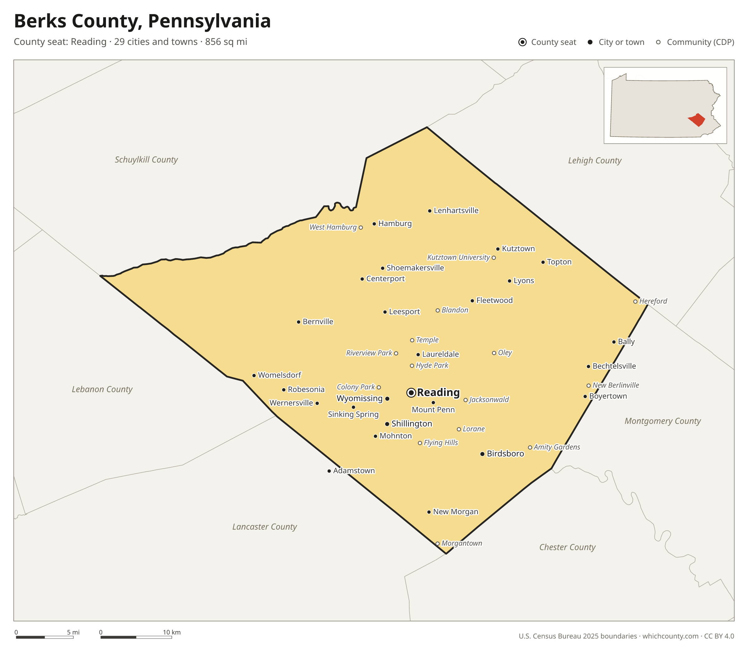
Berks County facts
- County seat
- Reading
- Population (2025 estimate)
- 440,072 +2.6% since 2020
- Land area
- 856 sq mi 19th largest of 67
- Water area
- 9 sq mi
- Population density
- 514 per sq mi
- Established
- 1752
- Named after
- Berkshire ceremonial and non-metropolitan but non-administrative county of England
- Largest city
- Reading 95,832
- Median household income
- $79,777
- Cities and towns
- 29 plus 58 CDPs
- ZIP codes
- 64
- Time zone
- Eastern
- FIPS code
- 42011
Cities and towns in Berks County
Berks County has 29 incorporated cities, towns and villages. Populations count the people living inside Berks County; cities that cross a county line also list the other counties.
| Name | Type | Population 2025 | Also in |
|---|---|---|---|
| Reading (county seat) | City | 95,832 | |
| Wyomissing | Borough | 11,285 | |
| Shillington | Borough | 5,542 | |
| Birdsboro | Borough | 5,161 | |
| West Reading | Borough | 4,590 | |
| Sinking Spring | Borough | 4,584 | |
| Hamburg | Borough | 4,551 | |
| Laureldale | Borough | 4,352 | |
| Boyertown | Borough | 4,333 | |
| Kutztown | Borough | 4,255 | |
| Fleetwood | Borough | 4,094 | |
| Mount Penn | Borough | 3,269 | |
| Kenhorst | Borough | 3,028 | |
| Womelsdorf | Borough | 2,986 | |
| Mohnton | Borough | 2,939 | |
| Wernersville | Borough | 2,831 | |
| Robesonia | Borough | 2,181 | |
| Topton | Borough | 2,062 | |
| Leesport | Borough | 1,964 | |
| St. Lawrence | Borough | 1,962 | |
| Shoemakersville | Borough | 1,387 | |
| Bally | Borough | 1,243 | |
| Bechtelsville | Borough | 888 | |
| Bernville | Borough | 876 | |
| Lyons | Borough | 444 | |
| Centerport | Borough | 321 | |
| Lenhartsville | Borough | 180 | |
| New Morgan | Borough | 46 | |
| Adamstown | Borough | 21 | Lancaster County |
Unincorporated communities (CDPs)
Census-designated places are communities without their own city government; the county provides their services.
| Community | Population | Also in |
|---|---|---|
| Blandon | 7,357 | |
| Pennside | 5,407 | |
| Whitfield | 5,226 | |
| Lorane | 4,601 | |
| Reiffton | 4,575 | |
| Amity Gardens | 4,499 | |
| Kutztown University | 4,182 | |
| Jacksonwald | 3,894 | |
| Riverview Park | 3,619 | |
| West Wyomissing | 3,289 | |
| Hyde Park | 2,846 | |
| Temple | 2,135 | |
| Grill | 1,903 | |
| West Hamburg | 1,896 | |
| South Temple | 1,882 | |
| Lincoln Park | 1,801 | |
| Flying Hills | 1,738 | |
| Fox Chase | 1,575 | |
| Hereford | 1,452 | |
| New Berlinville | 1,432 | |
| West Lawn | 1,384 | |
| Morgantown | 1,381 | Lancaster County |
| Springmont | 1,319 | |
| Muhlenberg Park | 1,259 | |
| Colony Park | 1,175 | |
| Oley | 1,153 | |
| Stony Creek Mills | 1,081 | |
| Greenfields | 986 | |
| Alleghenyville | 932 | |
| Spring Ridge | 917 | |
| Penn State Berks | 872 | |
| Dauberville | 854 | |
| Gouglersville | 694 | |
| Edenburg | 691 | |
| New Jerusalem | 645 | |
| Montrose Manor | 630 | |
| Bethel | 587 | |
| Mount Aetna | 544 | |
| Mertztown | 530 | |
| Stouchsburg | 452 | |
| Walnuttown | 426 | |
| Gibraltar | 398 | |
| Shartlesville | 387 | |
| Pennwyn | 384 | |
| Mohrsville | 341 | |
| Virginville | 336 | |
| Strausstown | 302 | |
| Douglassville | 279 | |
| Dryville | 256 | |
| Alsace Manor | 246 | |
| Baumstown | 221 | |
| New Schaefferstown | 189 | |
| Kempton | 148 | |
| Rehrersburg | 145 | |
| Bowers | 103 | |
| Frystown | 99 | |
| Maxatawny | 49 | |
| Schubert | 39 |
ZIP codes in Berks County
64 ZIP codes reach into Berks County. ZIP codes ignore county lines, so some also cover a neighboring county.
- 17026 also Lebanon County
- 17067 also Lebanon County
- 17087 also Lebanon County
- 17555 also Lancaster and Chester counties
- 17569 also Lancaster County
- 18011 also Lehigh County
- 18031 also Lehigh County
- 18041 also Montgomery, Lehigh and Bucks counties
- 18056
- 18062 also Lehigh County
- 18070 also Montgomery County
- 18092 also Lehigh County
- 19464 also Montgomery County
- 19501 also Lancaster County
- 19503
- 19504 also Montgomery County
- 19505 also Montgomery County
- 19506
- 19507
- 19508
- 19510
- 19511
- 19512 also Montgomery County
- 19516
- 19518
- 19520 also Chester County
- 19522
- 19523
- 19525 also Montgomery County
- 19526
- 19529 also Lehigh County
- 19530 also Lehigh County
- 19533
- 19534
- 19535
- 19536
- 19538
- 19539 also Lehigh County
- 19540 also Lancaster County
- 19541
- 19543 also Lancaster and Chester counties
- 19544
- 19545
- 19547
- 19550
- 19551 also Lebanon and Lancaster counties
- 19554
- 19555
- 19559
- 19560
- 19562
- 19564
- 19565
- 19567
- 19601
- 19602
- 19604
- 19605
- 19606
- 19607
- 19608
- 19609
- 19610
- 19611
Population of Berks County, 2020–2025
Berks County grew by 11,236 people (+2.6%) between April 2020 and July 2025: 357 more births than deaths and a net gain of 10,699 people from migration.
| Year (July 1) | Population |
|---|---|
| 2020 | 428,651 |
| 2021 | 429,671 |
| 2022 | 432,214 |
| 2023 | 435,061 |
| 2024 | 438,379 |
| 2025 | 440,072 |
Neighboring counties
- Schuylkill County northwest · 145,085 people
- Lehigh County northeast · 384,383 people
- Lebanon County west · 146,380 people
- Lancaster County southwest · 563,159 people
- Montgomery County southeast · 877,643 people
- Chester County south · 557,116 people
Printable Berks County map
The PDF is a vector file with real text: it prints sharp on Letter paper and you can search it for a town. The PNG is 2400 pixels wide for slides and documents. Both are free to use with a credit to WhichCounty.
- PDF (Letter) (176 KB)
- PNG (2400 px) (127 KB)
Paste this code to embed the map on your site:
Sources
- Boundaries: U.S. Census Bureau, 2025 Cartographic Boundary Files (1:500,000).
- Population: Census Bureau county and city estimates, Vintage 2025. CDP populations: American Community Survey 2020–2024.
- Places and ZIP codes: Census Bureau 2026 Gazetteer and 2020 ZIP Code Tabulation Area relationship files.
- County seat, founding year and name origin: Wikidata (CC0), checked against state sources.
Back to the Pennsylvania county map with all 67 counties. Found an error? Tell us.