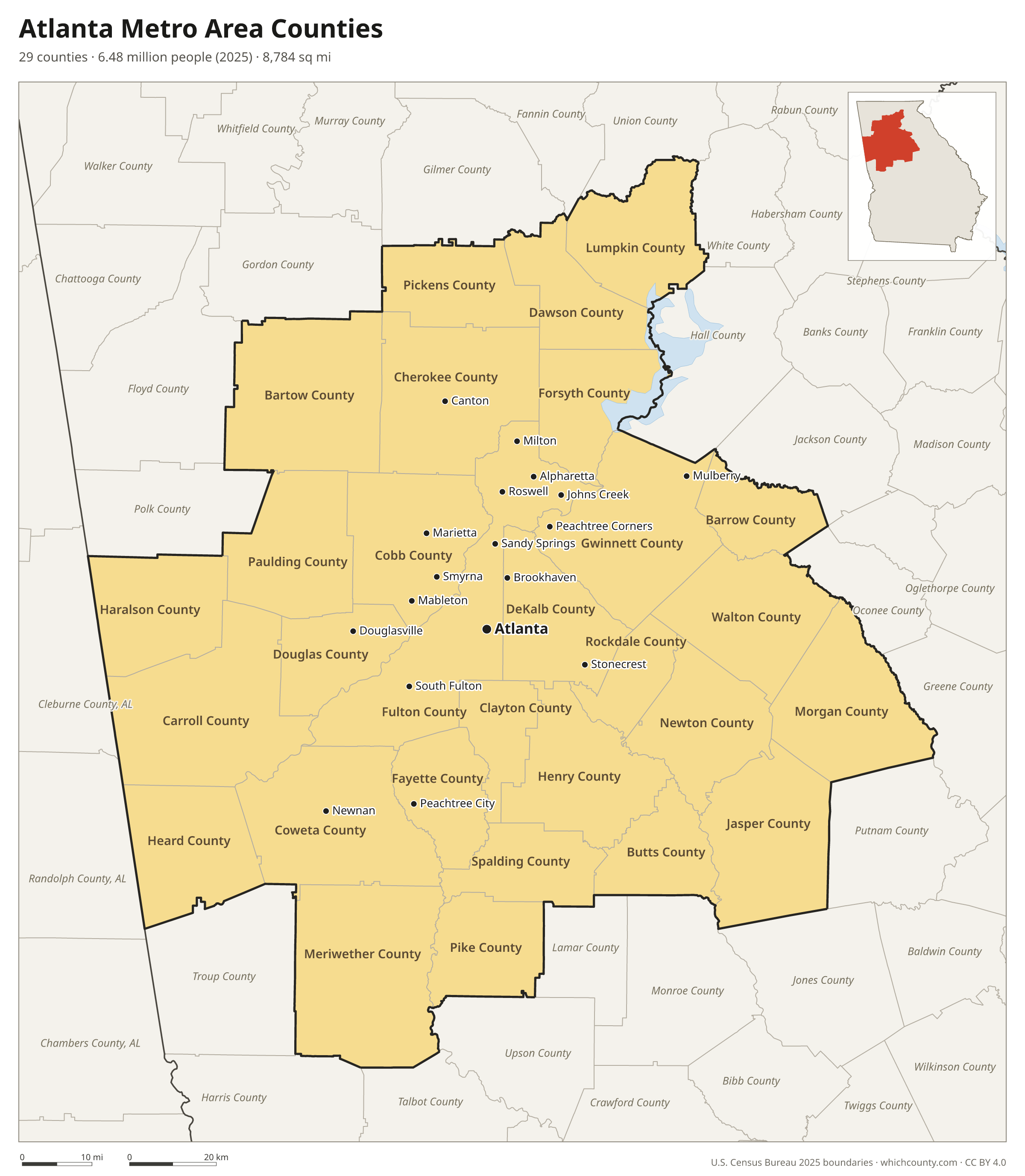
Atlanta Metro Area Counties
29 counties · 6.5 million people (2025) · 8,784 sq mi
The Atlanta metro area (officially the Atlanta-Sandy Springs-Roswell, GA Metropolitan Statistical Area) has 29 counties in Georgia, with 6,482,182 people in 2025. Fulton County is the most populous. The city of Atlanta itself lies in Fulton and DeKalb counties.

What county is Atlanta in?
Atlanta lies in 2 counties: Fulton County (92% of its 529,110 people) and DeKalb County (8%). It is the county seat of Fulton County. Fulton County map · DeKalb County map
Sandy Springs (105,013 people in 2025) is in Fulton County. Fulton County map
Roswell (91,505 people in 2025) is in Fulton County, with a small part without residents in Cobb County. Fulton County map · Cobb County map
Places and their populations by county: Census Bureau estimates, Vintage 2025, and the 2026 Gazetteer files.
The 29 counties of the Atlanta metro area
Sorted by population. 16 are central counties (the urban core); the others are outlying counties tied to it by commuting.
| County | County seat | Population 2025 | Change since 2020 | Land area (sq mi) | Type |
|---|---|---|---|---|---|
| Fulton County | Atlanta | 1,098,791 | +3% | 527 | Central |
| Gwinnett County | Lawrenceville | 1,018,099 | +6.3% | 431 | Central |
| Cobb County | Marietta | 793,345 | +3.6% | 340 | Central |
| DeKalb County | Decatur | 774,394 | +1.3% | 268 | Central |
| Cherokee County | Canton | 299,273 | +12.3% | 421 | Central |
| Clayton County | Jonesboro | 297,471 | −0.7% | 142 | Central |
| Forsyth County | Cumming | 282,805 | +12.5% | 225 | Central |
| Henry County | McDonough | 264,922 | +10.1% | 319 | Central |
| Paulding County | Dallas | 190,996 | +13.3% | 312 | Central |
| Coweta County | Newnan | 160,240 | +9.6% | 441 | Central |
| Douglas County | Douglasville | 154,293 | +6.9% | 200 | Central |
| Carroll County | Carrollton | 131,036 | +10% | 499 | Outlying |
| Newton County | Covington | 125,583 | +11.6% | 274 | Central |
| Fayette County | Fayetteville | 125,156 | +5% | 195 | Central |
| Bartow County | Cartersville | 120,800 | +11% | 459 | Outlying |
| Walton County | Monroe | 112,696 | +16.7% | 327 | Central |
| Barrow County | Winder | 99,773 | +19.4% | 161 | Outlying |
| Rockdale County | Conyers | 98,416 | +5.3% | 130 | Central |
| Spalding County | Griffin | 70,775 | +5.2% | 196 | Outlying |
| Pickens County | Jasper | 37,167 | +11.9% | 232 | Outlying |
| Lumpkin County | Dahlonega | 36,178 | +8% | 281 | Outlying |
| Dawson County | Dawsonville | 35,365 | +32% | 211 | Central |
| Haralson County | Buchanan | 33,066 | +10.5% | 282 | Outlying |
| Butts County | Jackson | 27,218 | +7% | 184 | Outlying |
| Morgan County | Madison | 22,095 | +10% | 347 | Outlying |
| Meriwether County | Greenville | 21,516 | +4.4% | 501 | Outlying |
| Pike County | Zebulon | 20,932 | +10.8% | 216 | Outlying |
| Jasper County | Monticello | 17,632 | +20.8% | 368 | Outlying |
| Heard County | Franklin | 12,149 | +6.5% | 296 | Outlying |
The metro area is part of the larger Atlanta–Athens-Clarke County–Sandy Springs, GA-AL Combined Statistical Area.
Growth and differences between the counties
Between April 2020 and July 2025 the Atlanta metro area gained 375,366 people (+6.1%). Its counties recorded 369,970 births and 251,679 deaths; net international migration added 181,339 people, and 74,640 more people moved in from other parts of the United States than moved away.
Fulton County alone is home to 17% of the metro area's people. DeKalb County is the most densely settled county, with 2,893 people per square mile, and Heard County the most rural, with 41. Median household income ranges from $57,340 in Meriwether County to $143,784 in Forsyth County.
| County | Births minus deaths | Net migration | People per sq mi | Median household income |
|---|---|---|---|---|
| Fulton County | +22,382 | +10,010 | 2,086 | $95,292 |
| Gwinnett County | +28,416 | +31,883 | 2,361 | $87,890 |
| Cobb County | +18,299 | +8,832 | 2,335 | $102,738 |
| DeKalb County | +22,229 | −11,956 | 2,893 | $80,644 |
| Cherokee County | +4,185 | +28,445 | 711 | $108,115 |
| Clayton County | +6,132 | −8,274 | 2,099 | $59,806 |
| Forsyth County | +4,039 | +27,750 | 1,259 | $143,784 |
| Henry County | +3,878 | +20,352 | 831 | $83,146 |
| Paulding County | +2,983 | +19,310 | 611 | $98,031 |
| Coweta County | +1,394 | +12,656 | 363 | $95,548 |
| Douglas County | +2,581 | +7,246 | 771 | $82,984 |
| Carroll County | +1,042 | +10,627 | 263 | $73,714 |
| Newton County | +1,028 | +11,962 | 459 | $77,179 |
| Fayette County | −1,029 | +7,055 | 643 | $111,978 |
| Bartow County | +783 | +11,065 | 263 | $82,243 |
| Walton County | +705 | +15,323 | 345 | $84,945 |
| Barrow County | +2,190 | +13,944 | 619 | $80,653 |
| Rockdale County | +412 | +4,437 | 758 | $77,247 |
| Spalding County | −703 | +4,048 | 361 | $62,071 |
| Pickens County | −709 | +4,598 | 160 | $78,930 |
| Lumpkin County | −396 | +2,985 | 129 | $77,448 |
| Dawson County | +287 | +8,247 | 168 | $92,991 |
| Haralson County | −378 | +3,497 | 117 | $72,127 |
| Butts County | −284 | +2,081 | 148 | $69,241 |
| Morgan County | −165 | +2,161 | 64 | $78,111 |
| Meriwether County | −530 | +1,422 | 43 | $57,340 |
| Pike County | −175 | +2,224 | 97 | $86,719 |
| Jasper County | −65 | +3,085 | 48 | $60,134 |
| Heard County | −240 | +964 | 41 | $65,868 |
Population and components of change: Census Bureau estimates, Vintage 2025 (April 1, 2020 to July 1, 2025). Income: American Community Survey 2020–2024 5-year estimates.
Questions about the Atlanta metro area counties
What counties are in the Atlanta metro area?
The 29 counties of the Atlanta-Sandy Springs-Roswell, GA metro area are Fulton, Gwinnett, Cobb, DeKalb, Cherokee, Clayton, Forsyth, Henry, Paulding, Coweta, Douglas, Carroll, Newton, Fayette, Bartow, Walton, Barrow, Rockdale, Spalding, Pickens, Lumpkin, Dawson, Haralson, Butts, Morgan, Meriwether, Pike, Jasper and Heard counties.
How many counties are in metro Atlanta?
29. 16 of them are central counties and 13 are outlying counties tied to the core by commuting. The wider Atlanta–Athens-Clarke County–Sandy Springs, GA-AL Combined Statistical Area includes more counties.
What is the largest county in the Atlanta area?
By population, Fulton County (1,098,791 people in 2025). By land area, Fulton County (527 sq mi).
Which county in the Atlanta area is growing fastest?
Dawson County grew fastest between April 2020 and July 2025 (+32%). Clayton County lost the most people (−0.7%).
Printable map
The PDF is a vector file for Letter paper; the PNG is 2400 pixels wide. Both are free to use with a credit to WhichCounty.
Cite this map
- APA
- WhichCounty. (2026, November 12). Atlanta Metro Area Counties Map [Map]. https://whichcounty.com/metro/atlanta/
- MLA
- “Atlanta Metro Area Counties Map.” WhichCounty, 12 Nov. 2026, whichcounty.com/metro/atlanta/.
- Chicago
- WhichCounty. “Atlanta Metro Area Counties Map.” Last modified November 12, 2026. https://whichcounty.com/metro/atlanta/.
County maps of Georgia
Other metro areas
- Augusta Metro Area Counties 7 counties
- Chattanooga Metro Area Counties 6 counties
- New York City Metro Area Counties 22 counties
- Los Angeles Metro Area Counties 2 counties
- Chicago Metro Area Counties 13 counties
- Dallas–Fort Worth Metro Area Counties 11 counties
- Houston Metro Area Counties 10 counties
- Washington, D.C. Metro Area Counties 23 counties
- Miami Metro Area Counties 3 counties
- Philadelphia Metro Area Counties 11 counties
- Phoenix Metro Area Counties 2 counties
- Boston Metro Area Counties 7 counties
- Inland Empire Metro Area Counties 2 counties
- San Francisco–Oakland Metro Area Counties 5 counties
- Detroit Metro Area Counties 6 counties
- Seattle Metro Area Counties 3 counties
- Minneapolis–St. Paul Metro Area Counties 15 counties
- Tampa Bay Metro Area Counties 4 counties
- Denver Metro Area Counties 10 counties
- Orlando Metro Area Counties 4 counties
- Charlotte Metro Area Counties 11 counties
- Baltimore Metro Area Counties 7 counties
- St. Louis Metro Area Counties 15 counties
- San Antonio Metro Area Counties 8 counties
Sources
- Metro area definition: U.S. Office of Management and Budget, Core Based Statistical Areas, July 2023 delineation (published by the Census Bureau).
- Boundaries: U.S. Census Bureau 2025 cartographic boundary files. Population: Census Bureau estimates, Vintage 2025.