Minneapolis–St. Paul Metro Area Counties
15 counties · 3.8 million people (2025) · 7,048 sq mi
The Minneapolis–St. Paul metro area (officially the Minneapolis-St. Paul-Bloomington, MN-WI Metropolitan Statistical Area) has 15 counties in Minnesota and Wisconsin, with 3,790,295 people in 2025. Hennepin County is the most populous.

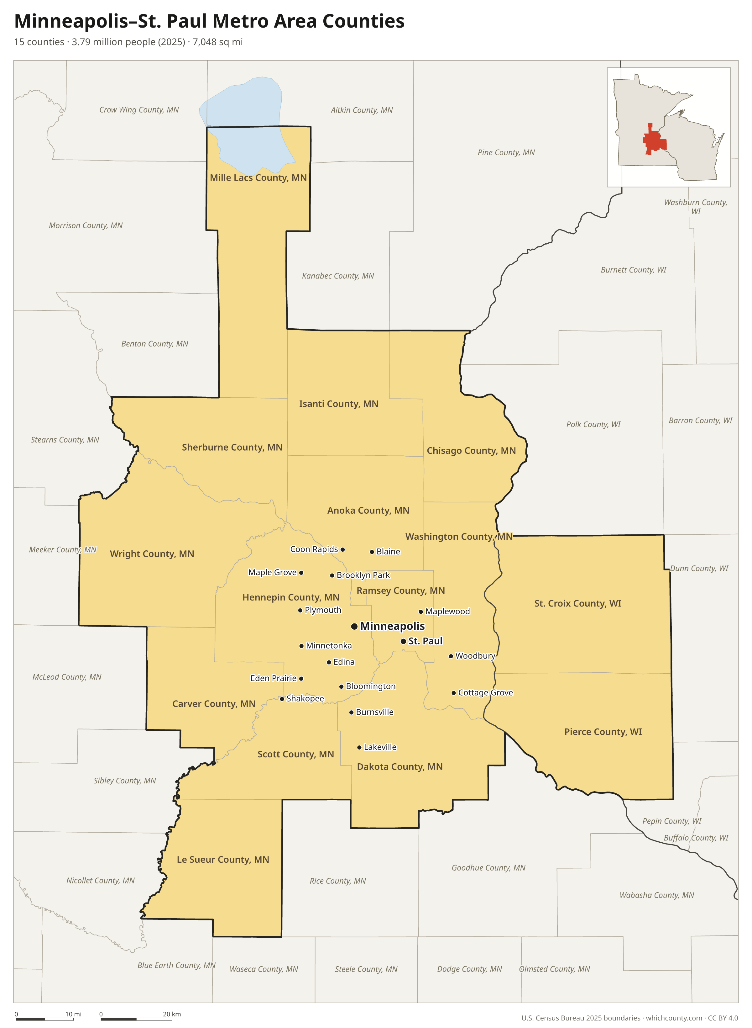
The 15 counties of the Minneapolis–St. Paul metro area
Sorted by population. 9 are central counties (the urban core); the others are outlying counties tied to it by commuting.
| County | State | County seat | Population 2025 | Change since 2020 | Land area (sq mi) | Type |
|---|---|---|---|---|---|---|
| Hennepin County | Minnesota | Minneapolis | 1,284,784 | +0.3% | 554 | Central |
| Ramsey County | Minnesota | Saint Paul | 541,623 | −1.9% | 152 | Central |
| Dakota County | Minnesota | Hastings | 457,710 | +4.1% | 563 | Central |
| Anoka County | Minnesota | Anoka | 381,605 | +4.9% | 422 | Central |
| Washington County | Minnesota | Stillwater | 286,895 | +7.2% | 385 | Central |
| Scott County | Minnesota | Shakopee | 159,017 | +5.4% | 356 | Central |
| Wright County | Minnesota | Buffalo | 157,559 | +11.5% | 661 | Central |
| Carver County | Minnesota | Chaska | 114,379 | +7% | 354 | Central |
| Sherburne County | Minnesota | Elk River | 104,194 | +7.2% | 433 | Central |
| St. Croix County | Wisconsin | Hudson | 98,276 | +5.1% | 722 | Outlying |
| Chisago County | Minnesota | Center City | 59,142 | +4.5% | 415 | Outlying |
| Isanti County | Minnesota | Cambridge | 44,386 | +7.9% | 436 | Outlying |
| Pierce County | Wisconsin | Ellsworth | 43,519 | +3.1% | 574 | Outlying |
| Le Sueur County | Minnesota | Le Center | 29,453 | +2.8% | 449 | Outlying |
| Mille Lacs County | Minnesota | Milaca | 27,753 | +4.8% | 572 | Outlying |
The metro area is part of the larger Minneapolis-St. Paul, MN-WI Combined Statistical Area.
Printable map
The PDF is a vector file for Letter paper; the PNG is 2400 pixels wide. Both are free to use with a credit to WhichCounty.
County maps of Minnesota and Wisconsin
Other metro areas
- New York City Metro Area Counties 22 counties
- Los Angeles Metro Area Counties 2 counties
- Chicago Metro Area Counties 13 counties
- Dallas–Fort Worth Metro Area Counties 11 counties
- Houston Metro Area Counties 10 counties
- Atlanta Metro Area Counties 29 counties
- Washington, D.C. Metro Area Counties 23 counties
- Miami Metro Area Counties 3 counties
- Philadelphia Metro Area Counties 11 counties
- Phoenix Metro Area Counties 2 counties
- Boston Metro Area Counties 7 counties
- Inland Empire Metro Area Counties 2 counties
- San Francisco–Oakland Metro Area Counties 5 counties
- Detroit Metro Area Counties 6 counties
- Seattle Metro Area Counties 3 counties
- Tampa Bay Metro Area Counties 4 counties
- Denver Metro Area Counties 10 counties
- Orlando Metro Area Counties 4 counties
- Charlotte Metro Area Counties 11 counties
- Baltimore Metro Area Counties 7 counties
- St. Louis Metro Area Counties 15 counties
- San Antonio Metro Area Counties 8 counties
- Austin Metro Area Counties 5 counties
- Portland Metro Area Counties 7 counties
- Cleveland Metro Area Counties 6 counties
- San Francisco Bay Area Counties 9 counties
Sources
- Metro area definition: U.S. Office of Management and Budget, Core Based Statistical Areas, July 2023 delineation (published by the Census Bureau).
- Boundaries: U.S. Census Bureau 2025 cartographic boundary files. Population: Census Bureau estimates, Vintage 2025.